
Județ
Pour les articles homonymes, voir Judet.


Un județ (/ʒuˈdet͡s/) est une division administrative :
- de la Valachie, de 1330 à 1859 ;
- des deux Principautés danubiennes, de 1718 à 1859 ;
- de la Principauté de Roumanie, de 1859 à 1881 ;
- du Royaume de Roumanie, de 1881 à 1947 ;
- de la République populaire roumaine, de 1948 à 1952;
- dans les limites actuelles[Note 1] et après 16 ans de regroupement en régions[1], de la République socialiste de Roumanie, puis de la Roumanie, depuis 1968 ;
- de la République de Moldavie, de 1998 à 2003.
Les județe sont aujourd'hui, en Roumanie, l'équivalent des départements français avant la décentralisation française. Ils sont en effet dirigés par un préfet (prefect) assisté d'un Conseil général élu (Consiliul județean) à la tête duquel se trouve un président élu pour quatre ans par les conseillers généraux.
Étymologie
Le mot județ, au pluriel județe, vient de l'ancien roumain « Жуδε » (jude : « juge », « bourgmestre »)[2], qui vient du latin médiéval « judex », lui-même issu du latin judicium.
Histoire
La division administrative en județe existait depuis le XIVe siècle en Valachie ; la Moldavie et la Transylvanie avaient le même système, mais leurs divisions étaient appelées respectivement ținuturi et megieșuri (comitate en roumain moderne). Chaque județ ou ținut était dirigé par un jude nommé par le voïvode, aux pouvoirs administratifs, fiscaux et judiciaires.
Avec la création de la Roumanie, les județe modernes apparaissent au début du XIXe siècle. Étendus au début du XXe siècle à l'ensemble des pays roumanophones, les nouveaux județe conservent l'étendue territoriale des anciens județe, ținuturi et megieșuri, mais sont organisés d'après le modèle français, avec un préfet qui représentait le gouvernement et un Conseil général élu.
-
 Județe (megyés) de Transylvanie au XVIIe siècle.
 -
 Les județe en Principauté de Valachie entre 1601 et 1718.
 -
 Les Bezirke du Grand-Duché de Transylvanie et les județe des principautés danubiennes en 1711.
 -
 Les ținuturi en Principauté de Moldavie entre 1601 et 1718.
 -
 Les județe des principautés danubiennes en 1800, d'après N. Iorga et C. Giurescu.
 -
 Les județe de la Principauté de Roumanie entre 1856 et 1878.
 -
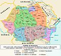
 Les județe du Royaume de Roumanie entre 1878 et 1913.
 -
 Les 70 județe du Royaume de Roumanie entre 1936 et 1939.
 -
 Les 57 județe de Roumanie entre 1945 et 1951.
 -
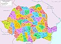
 Les 41 județe de Roumanie depuis le retour à la démocratie (1989)
 -
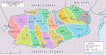
 Étendues comparées et chefs-lieux des județe d'avant 1940 et actuels, en surimposition sur les anciennes régions historiques.
 -
 Les 11 județe de la République de Moldavie entre 1998 et 2003.


.svg)


En 1951, le gouvernement communiste modifia l'organisation territoriale, adoptant le modèle soviétique de régions (dont certaines, où vivaient des minorités ethniques, autonomes) divisées en raions. Trois ans après son accession au pouvoir, en 1968, Nicolae Ceaușescu réintroduisit des județe, mais avec une nouvelle organisation territoriale, et avec des secrétaires de județ du parti unique à leur tête. En 1981, les județe d'Ilfov et de Ialomița furent réorganisés pour donner la configuration actuelle, avec les județe de Giurgiu (Vlașca avant-guerre), Călărași, Ialomița et Ilfov. Le pouvoir post-communiste a conservé l'organisation territoriale héritée du régime Ceaușescu, à un détail près : en 1995, l'Ilfov qui dépendait de Bucarest en tant qu'arrondissement rural retrouva son statut de județ à part entière. En revanche, avec le retour progressif à la démocratie, le modèle français fut réintroduit, avec un préfet et un conseil général élu.
Ultérieurement, deux autres niveaux d'organisation administrative ont été ajoutés : les macro-régions (Niveau I) et les régions de développement (Niveau II), mais seuls les județe (Niveau III) sont de véritables unités administratives pourvues d'institutions propres et d'instances décisionnelles locales (voir Subdivisions de la Roumanie).
Sur le plan héraldique, le régime communiste avait supprimé les armoiries des anciens județe, ținuturi et megieșuri. Le régime de Ceaușescu recréa pour les nouveaux județe des armoiries qui comportaient les emblèmes communistes. Après le retour à la démocratie, ces armoiries « communistes » furent remplacées par de nouvelles armoiries, inspirées des symboles d'avant-guerre réarrangés selon la division territoriale actuelle, et respectant plus ou moins les règles héraldiques.
Après l'indépendance de la République de Moldavie, la majorité autochtone et roumanophone de ce pays, en lutte politique contre la domination des colons russophones, a tenté d'y réintroduire, par les lois de 1998, le modèle franco-roumain des județe : il y en eut onze. Mais cela ne dura pas : cédant à la dépendance énergétique, économique et politique envers la Russie, les « autochtonistes » laissèrent le pouvoir aux communistes en 2003, et ces derniers rétablirent aussitôt le modèle soviétique des raions.
Dans cette division territoriale actuelle, un total de 41 județe, ainsi que la municipalité de Bucarest, constituent les divisions administratives officielles de la Roumanie. Ils représentent le niveau 3 des subdivisions selon la nomenclature des unités territoriales statistiques (NUTS) établie au sein de l'Union européenne. La plupart des județe sont nommés d'après un cours d'eau, tandis que d'autres sont nommés d'après des villes notables en leur sein, comme leur capitale.
Liste des județe de Roumanie
Depuis 2003, la Roumanie est divisée selon la NUTS niveau III, en 41 județe et une municipalité, de la façon suivante :
| Județ | Capitale | Étymologie | Région de développement | Région historique | Code ISO | Code postal | Indicatif téléphonique | Code NUTS | Population (2011) |
Superficie | Carte |
|---|---|---|---|---|---|---|---|---|---|---|---|
| Alba |
Alba Iulia |
Nom latin de Beligrad ou Gyula Fehervar (cité blanche royale) | Centre | Transylvanie |
AB | 51 | 58 | RO121 | 342 376 | 6 242 km2 | 
|
| Arad |
Arad |
Ville d'Arad, du slave Rad, prospère, heureuse | Ouest | Crișana/Banat |
AR | 31 | 57 | RO421 | 430 629 | 7 754 km2 | 
|
| Argeș |
Pitești |
Argeș (rivière) | Sud-Munténie | Munténie |
AG | 11 | 48 | RO311 | 612 431 | 6 862 km2 | 
|
| Bacău |
Bacău |
Ville de Bacău, du hongrois Bakó, du slave Bâk : hêtre, hetraie | Nord-Est | Moldavie |
BC | 60 | 34 | RO211 | 616 168 | 6 621 km2 | 
|
| Bihor |
Oradea |
Pays de Biharia | Nord-Ouest | Crișana |
BH | 41 | 59 | RO111 | 575 398 | 7 544 km2 | 
|
| Bistrița-Năsăud |
Bistrița |
Bistrița : rapide en langue slave, et Năsăud du slave Nas-voda : au milieu des eaux | Nord-Ouest | Transylvanie |
BN | 42 | 63 | RO112 | 286 225 | 5 355 km2 | 
|
| Botoșani |
Botoșani |
Ville de Botoșani | Nord-Est | Moldavie |
BT | 71 | 31 | RO212 | 412 626 | 4 986 km2 | 
|
| Brașov |
Brașov |
Ville de Brașov | Centre | Transylvanie (Pays de la Bârsa) |
BV | 50 | 68 | RO122 | 549 217 | 5 363 km2 | 
|
| Brăila |
Brăila |
Ville de Brăila | Sud-Est | Munténie |
BR | 81 | 39 | RO221 | 321 212 | 4,766 km2 | 
|
| Bucarest |
Municipalité de Bucarest[Note 2] | Ville de Bucarest | Bucarest-Ilfov | Munténie |
B | 01 à 06 [Note 3] |
1x [Note 4] |
RO321 | 1 883 425 | 228 km2 | 
|
| Buzău |
Buzău |
Buzău (rivière) | Sud-Est | Munténie |
BZ | 12 | 38 | RO222 | 451 069 | 6 103 km2 | 
|
| Caraș-Severin |
Reșița |
Anciens județe de Caraș et de Severin | Ouest | Banat |
CS | 32 | 55 | RO422 | 295 579 | 8 514 km2 | 
|
| Călărași |
Călărași |
Ville de Călărași : cavaliers | Sud-Munténie | Munténie |
CL | 91 | 42 | RO312 | 306 691 | 5 088 km2 | 
|
| Cluj |
Cluj-Napoca |
Comitat de Cluj, du latin Clusius : clos | Nord-Ouest | Transylvanie |
CJ | 40 | 64 | RO113 | 691 106 | 6 674 km2 | 
|
| Constanța |
Constanța |
Ville de Constanța ou Constanza | Sud-Est | Dobrogée |
CT | 90 | 41 | RO223 | 684 082 | 7 071 km2 | 
|
| Covasna |
Sfântu Gheorghe |
Covasna (rivière) | Centre | Transylvanie (Pays sicule) |
CV | 52 | 67 | RO123 | 210 177 | 3 710 km2 | 
|
| Dâmbovița |
Târgoviște |
Dâmbovița (rivière) | Sud-Munténie | Munténie |
DB | 13 | 45 | RO313 | 518 745 | 4 054 km2 | 
|
| Dolj |
Craiova |
Dolj : bas-Jiu en langue slave | Sud-Ouest | Olténie |
DJ | 20 | 51 | RO411 | 660 544 | 7 414 km2 | 
|
| Galați |
Galați |
Ville de Galați | Sud-Est | Moldavie |
GL | 80 | 36 | RO224 | 536 167 | 4 466 km2 | 
|
| Giurgiu |
Giurgiu |
Ville de Giurgiu, ancien comptoir génois de San-Giorgio | Sud-Munténie | Munténie |
GR | 08 | 46 | RO314 | 281 422 | 3 526 km2 | 
|
| Gorj |
Târgu Jiu |
Gorj : haut-Jiu en langue slave | Sud-Ouest-Olténie | Olténie |
GJ | 21 | 53 | RO412 | 341 594 | 5 602 km2 | 
|
| Harghita |
Miercurea-Ciuc |
Montagnes de Harghita | Centre | Transylvanie (Pays sicule) |
HR | 53 | 66 | RO124 | 310 867 | 6 639 km2 | 
|
| Hunedoara |
Deva |
Ville de Hunedoara | Ouest | Transylvanie |
HD | 33 | 54 | RO423 | 418 565 | 7 063 km2 | 
|
| Ialomița |
Slobozia |
Ialomița (rivière) | Sud-Munténie | Munténie |
IL | 92 | 43 | RO315 | 274 148 | 4 453 km2 | 
|
| Iași |
Iași |
Ville de Iași, comté des Iasses | Nord-Est | Moldavie |
IS | 70 | 32 | RO213 | 772 348 | 5 476 km2 | 
|
| Ilfov |
Buftea |
Ilfov (rivière) | Bucarest-Ilfov | Munténie |
IF | 07 | 1x | RO322 | 388 738 | 1 583 km2 | 
|
| Maramureș |
Baia Mare |
Marmatie | Nord-Ouest | Marmatie/Transylvanie |
MM | 43 | 62 | RO114 | 478 659 | 6 304 km2 | 
|
| Mehedinți |
Drobeta-Turnu Severin |
Mehadia | Sud-Ouest-Olténie | Olténie/Banat |
MH | 22 | 52 | RO413 | 265 390 | 4 933 km2 | 
|
| Mureș |
Târgu Mureș |
Mureș (rivière) | Centre | Transylvanie (Pays sicule) |
MS | 54 | 65 | RO125 | 550 846 | 6 714 km2 | 
|
| Neamț |
Piatra Neamț |
Cetatea Neamțului : la forteresse de l'Allemand | Nord-Est | Moldavie |
NT | 61 | 33 | RO214 | 470 766 | 5 896 km2 | 
|
| Olt |
Slatina |
Olt (rivière) | Sud-Ouest-Olténie | Munténie/Olténie |
OT | 23 | 49 | RO414 | 436 400 | 5 498 km2 | 
|
| Prahova |
Ploiești |
Prahova (rivière) | Sud-Munténie | Munténie |
PH | 10 | 44 | RO316 | 762 886 | 4 716 km2 | 
|
| Satu Mare |
Satu Mare |
Ville de Satu-Mare : le Grand-Village | Nord-Ouest | Crișana |
SM | 44 | 61 | RO115 | 344 360 | 4 418 km2 | 
|
| Sălaj |
Zalău |
Sălaj (rivière) | Nord-Ouest | Transylvanie |
SJ | 45 | 60 | RO116 | 224 384 | 3 864 km2 | 
|
| Sibiu |
Sibiu |
Ville de Sibiu | Centre | Transylvanie |
SB | 55 | 69 | RO126 | 397 322 | 5 432 km2 | 
|
| Suceava |
Suceava |
Suceava (rivière) | Nord-Est | Moldavie (Bucovine)/Marmatie |
SV | 72 | 30 | RO215 | 634 810 | 8 553 km2 | 
|
| Teleorman |
Alexandria |
Teleorman (rivière), du turc Deli-Orman : forêt folle | Sud-Munténie | Munténie |
TR | 14 | 47 | RO317 | 380 123 | 5 790 km2 | 
|
| Timiș |
Timișoara |
Timiș (rivière) | Ouest | Banat |
TM | 30 | 56 | RO424 | 683 540 | 8 697 km2 | 
|
| Tulcea |
Tulcea |
Ville de Tulcea | Sud-Est | Dobrogée |
TL | 82 | 40 | RO225 | 213 083 | 8 499 km2 | 
|
| Vaslui |
Vaslui |
Vasluieț (rivière) | Nord-Est | Moldavie |
VS | 73 | 35 | RO216 | 395 499 | 5 318 km2 | 
|
| Vâlcea |
Râmnicu Vâlcea |
Vâlcea, du slave Vâlk : le loup | Sud-Ouest-Olténie | Munténie/Olténie |
VL | 24 | 50 | RO415 | 371 714 | 5 765 km2 | 
|
| Vrancea |
Focșani |
Montagnes de Vrancea | Sud-Est | Moldavie/Munténie |
VN | 62 | 37 | RO226 | 340 310 | 4 857 km2 | 
|
Notes et références
Notes
- À une exception près : les județe d'Ilfov, de Călărași et Ialomița, où une modification intervient en 1980
- Bucarest est une municipalité du județ d'Ilfov mais son statut administratif est égal à celui des județe, les 6 arrondissements ayant le statut de communes.
- Bucarest est divisée en 6 arrondissements (sectoare).
- Bucarest et Ilfov ont le même code.
Références
- (en) Cet article est partiellement ou en totalité issu de l’article de Wikipédia en anglais intitulé « Counties of Romania » (voir la liste des auteurs).
- Entre 1952 et 1968 la République socialiste de Roumanie adopta une organisation territoriale de type soviétique en régions et raions.
- Constantin C. Giurescu, Istoria Românilor vol. II, I-e partie, Fundația Regală pentru Literatură și Artă, Bucarest 1943, p. 398.
Articles connexes
- Organisation territoriale de la Roumanie
- Liste des dirigeants des județe roumains
- Régions historiques de Roumanie
- Régions administratives de la République populaire roumaine
- Subdivisions de la Moldavie
- Plaque d'immatriculation roumaine