
Utilisateur:Io Herodotus/Enclaves/brouillon
Enclaves internationales qui sont également des exclaves[modifier | modifier le code]
| Nom[1][2] | Surface (km2) | Exclave de | Enclavé par | Coordonnées | Notes |
|---|---|---|---|---|---|
| Île d'Apipé[3] (4) | ~320 | 27° 31′ S, 56° 51′ O | Quatre îles adjacentes (Apipé la Grande, Isla Apipé Chico, Isla Los Patos and Isla San Martín) with territorial water borders in the Río Paraná, 39 km east of Isla Entre Rios. Island areas are about 276, 23.8, 11.8 and 3.7 km², respectively. | ||
| [3]Isla Entre Ríos | ~36 | 27° 25′ S, 57° 30′ O | Uninhabited island with territorial water border in the Río Paraná, 39 km west of Isla Apipé. | ||
| Isla Martín García | ~2 | 34° 10′ 47″ S, 58° 15′ 00″ O | Territorial water border on the Uruguay side of Río de la Plata. Designated as a nature reserve under the jurisdiction of Argentina in 1973. | ||
| Artsvashen | ~40 | 40° 38′ N, 45° 30′ E | Contrôlé par l'Azerbaïdjan depuis la Guerre du Haut-Karabagh | ||
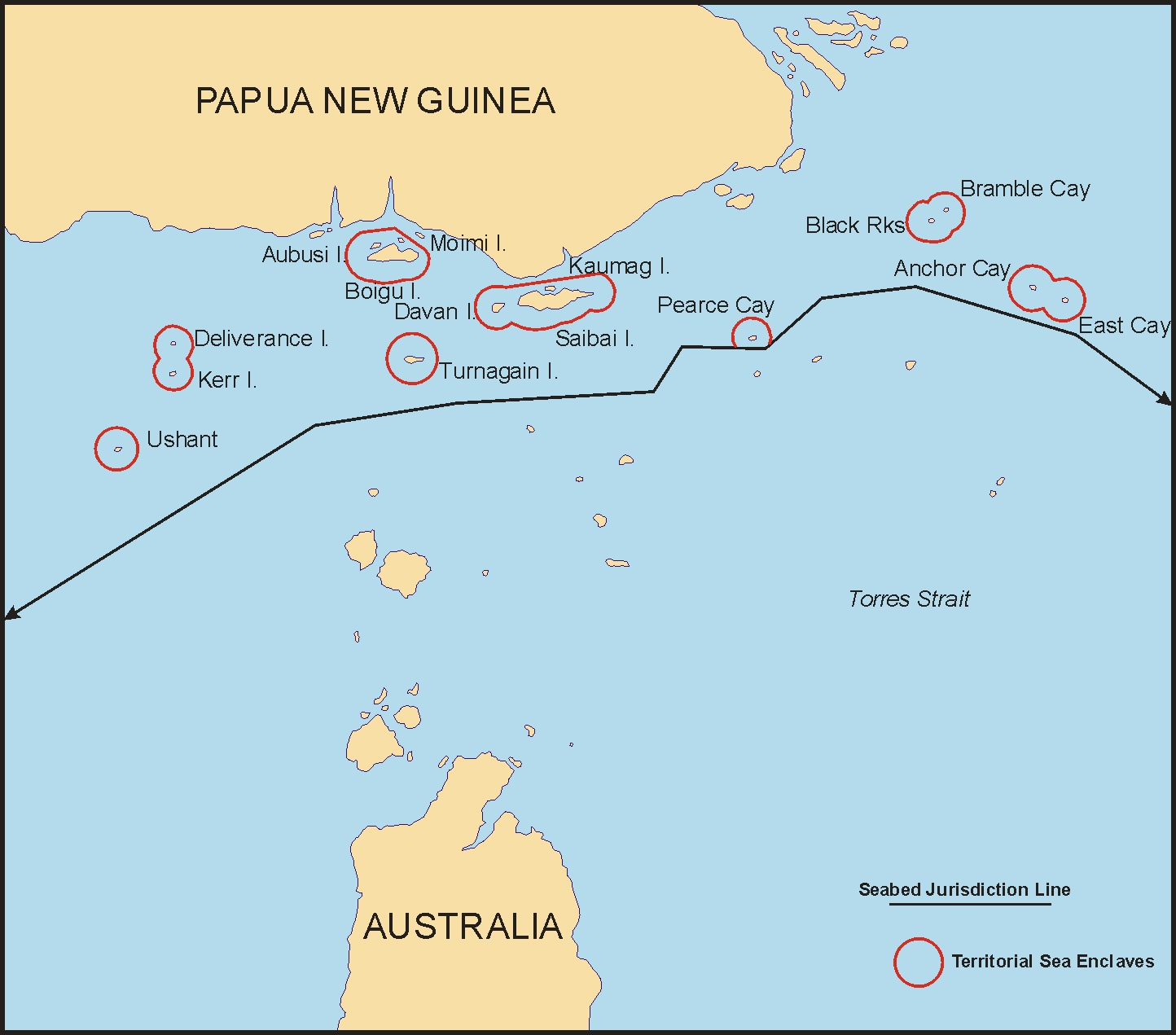
| Torres Strait Islands (7) | ~220 (land area) | 9° 25′ 23″ S, 142° 32′ 10″ E | The islands of Anchor Cay, Aubusi Island, Black Rocks, Boigu Island (89.6 km²), Bramble Cay (0.036 km²), Dauan Island (4 km²), Deliverance Island, East Cay, Kaumag Island, Kerr Islet, Moimi Island, Saibai Island (107.9 km²), Turnagain Island (12 km²) and Turu Cay, along with their territorial seas, form seven enclaves within the maritime area of Papua New Guinea under a treaty effective in 1985. The territorial sea of each island does not extend beyond three nautical miles.[4][5] The mainland of Papua New Guinea is only 6 km from Boigu. | ||
| Jungholz | 7 | 47° 34,3′ N, 10° 27,3′ E | Connected at a quadripoint at the summit of the mountain Sorgschrofen (1636 m); accessible only through Germany. Vinokurov (2007) states, "For all purposes, a connection in a single point does not mean anything. It is just like being completely separated. One cannot pass through a single point, nor is it possible to transport goods. It is not even possible to lay a telephone line."[3] | ||
| Yukhari Askipara | ~37 | 41° 03′ 58″ N, 45° 01′ 24″ E | A destroyed village controlled by Armenia since the Nagorno-Karabakh War in May 1992; west of the town of Qazax. | ||
| Barkhudarli | ~22 | 40° 59′ 36″ N, 45° 13′ 31″ E | Controlled by Armenia since the Nagorno-Karabakh War in May 1992; west-southwest of the town of Qazax. | ||
| Karki | ~10 | 39° 47,3′ N, 44° 57′ E | Contrôlé par l'arménie depuis la Guerre du Haut-Karabagh | ||
| "Yaradullu" (north and south) | 0.12 and 0.06 | 41° 00′ 51,8″ N, 45° 26′ 12,2″ E | Two farmland enclaves just across the border from the village of Yaradullu[6][7] (55 m at the closest point). They are 750 m and 1500 m southwest of the municipality of Tatli on the west bank of the Akhum River; approximately 300x400 m and 300x200 m. The surrounding Armenian territory has been occupied by Azerbaijan since the Nagorno-Karabakh War in May 1992, so that these two small pockets of land are de facto no longer exclaves. | ||
| Dahagram-Angarpota | 25.95 | 26° 18′ N, 88° 57′ E | Dahagram–Angarpota is a composite enclave of two adjoining chhits. It is separated from the contiguous area of Bangladesh at its closest point by 178 mètres ( Unité « » inconnue du modèle {{Conversion}}.). The enclave has an estimated population of 20,000. After the exchange of enclaves with India under the Land Boundary Agreement on 31 July 2015, Bangladesh retained it as an exclave. The Tin Bigha Corridor, a strip of Indian territory 85 mètres ( Unité « » inconnue du modèle {{Conversion}}.) wide running from the enclave to the Bangladesh mainland at its nearest approach, was leased to Bangladesh for 999 years for access to the enclave.[1][8][9] | ||
| Baarle-Hertog (22 parcels) | 2.3448 | 51° 26′ 13″ N, 4° 55′ 43″ E (H1) | A group of 22 Belgian enclaves in the southern Netherlands. Enclaves H1 and H2 are connected at a single point. | ||
| Međurječje | 3.9584 | 43° 33′ 30″ N, 19° 25′ 30″ E | Home land of Bosnia-Herzegovina is 1,130 meters to the north. Sastavci is the name of the neighboring village in Serbia. | ||
| Quitasueño | 3,577, including water area[10] | 14° 24′ 01″ N, 81° 07′ 47″ O[11] (QS32)[10] | On 19 November 2012, the International Court of Justice upheld Colombia's claim to Quitasueño, plus a 12-NM territorial zone, and re-defined Nicaragua's EEZ, thus surrounding the island bank.[12] It deemed one of the bank's 54 features to be an island at high tide (elevation 70 cm, area 1 m²)[13] and created enclaves as an equitable solution.[14] The area of the bank, excluding the 12-mile zone, is ~290 km².[15] | ||
| Serrana | ~2,500, including water area | 14° 17′ 13″ N, 80° 21′ 48″ O (Southwest Cay) | On 19 November 2012, ICJ upheld Colombia's claim to Serrana, plus a 12-NM territorial zone, and re-defined Nicaragua's EEZ, surrounding the island bank.[12] The land area is ~0.11 km², and the area of the bank, excluding the 12-mile zone, is ~322 km².[15] Colombia decried the loss of maritime areas and creation of "'enclaves' around Quitasueño and Serrana that could restrict" access.[12] | ||
| Brezovica Žumberačka (2) | 0.0183+ | 45° 41′ 22″ N, 15° 18′ 12″ E | The first enclave contains four dwellings surrounded by agricultural land near the Slovenian village of Brezovica pri Metliki. It is about 437 m long and 60 m wide covering 1.83 ha. Confirmed by both Croatian and Slovenian cadaster maps, it lies about 100 meters away from the main border at the closest point.[6][7][16][17]
A second enclave lies within 300 meters of the first. It was created on 29 June 2017 when the Permanent Court of Arbitration decided that a disputed 2.4 ha parcel is part of Slovenia and that the border follows Slovenian cadastral limits, thus completing the encirclement of the second Croatian enclave.[18][19] Croatia has stated that it will ignore the arbitration decision.[20] | ||
| Ormidhia | 1.694 | Modèle:Country data Akrotiri and Dhekelia Sovereign Base Area | 34° 59′ 33″ N, 33° 46′ 49″ E | One of four small exclaves surrounded by Dhekelia, a British Overseas Territory in southeastern Cyprus. | |
| Xylotymbou | 0.947 | Modèle:Country data Akrotiri and Dhekelia Sovereign Base Area | 35° 01′ 03″ N, 33° 44′ 37″ E | One of four small exclaves surrounded by Dhekelia, a British Overseas Territory. | |
| "Electricity Authority of Cyprus" Refugee Settlement | ~0.28 | Modèle:Country data Akrotiri and Dhekelia Sovereign Base Area | 34° 59′ 04″ N, 33° 44′ 37″ E | North of Dhekelia Power Station from which it is separated by a British road; the closest point between the two exclaves is 21 meters. | |
| Dhekelia Power Station | ~0.161 | Modèle:Country data Akrotiri and Dhekelia Sovereign Base Area | 34° 58′ 49″ N, 33° 44′ 45″ E | Partially borders the coast but enclosed by UK waters and UK land elsewhere; the power station is owned by the Electricity Authority of Cyprus (EAC); no permanent population. | |
| Münsterbildchen | 1.826 | 50° 39′ 36″ N, 6° 11′ 24″ E | West of Vennbahn trackbed; northernmost German enclave, mainly home to industrial and warehouse structures. | ||
| Roetgener Wald | 9.98 | 50° 38′ 12″ N, 6° 14′ 32″ E | Western part of Lammersdorf, southern part of Roetgen, and intervening forest (Forst Rötgen); west and south of Vennbahn trackbed. From 1922 to 1958, the center portion (between Grenzweg and a boundary with three turning points west of the Schleebach stream) was Belgian territory. Until 1949, the east–west road that connected the two outer (German) portions was also German territory; therefore, the German land formed one oddly-shaped enclave (that also included the road to Konzen). In 1949, it was split into two enclaves when Germany ceded the roads to Belgium;[21] in 1958, Belgium returned the east-west road and also ceded the center section of the current enclave to Germany. | ||
| Rückschlag | 0.016 | 50° 35′ 52″ N, 6° 14′ 53″ E | Part of city of Monschau, west of Vennbahn trackbed; smallest German exclave, consisting of a house and a garden. | ||
| Mützenich (Monschau) (en) | 12.117 | 50° 33′ 54″ N, 6° 13′ 05″ E | West of Belgium's Vennbahn trackbed. | ||
| Ruitzhof | 0.937 | 50° 31′ 29″ N, 6° 11′ 39″ E | Part of city of Monschau, west of Vennbahn trackbed; southernmost Vennbahn enclave after 1949 (when Belgium annexed the Hemmeres enclave). | ||
| Büsingen am Hochrhein | 7.62 | 47° 42′ N, 8° 42′ E | At its closest, less than 700 meters from Germany proper (to the east). | ||
| Campione d'Italia | 1.6 | 45° 58′ 10″ N, 8° 58′ 25″ E | Séparé de 1 km du reste de l'Italie
usage du franc suisse mais les habitants paient leur impôts en Italie | ||
| Barak (Kirghizistan) (de facto) | 2.07[22] | 40° 40′ N, 72° 46′ E | Kyrgyzstan's 1991 pre-independence border is the de jure international border, but much of it is hotly disputed with its neighbors. In August 1999, the area around Barak was occupied by Uzbekistan, cutting it off from Kyrgyz territory. Uzbek forces dug up and blockaded the road to Ak-Tash[23] while also allegedly seizing large areas of Kyrgyz land that had been loaned in the Soviet era but never returned.[24] They entrenched themselves within much of Kyrgyz border territory and refused to leave.[25] Barak became a de facto enclave only 1.5 km from the shifted main border.[26] Four Uzbek enclaves and Barak are major sticking points in delimitation talks,[27] and disputes have centered on the areas of Barak, Sokh, Gava and Gavasay (stream).[28] (Map) | ||
| Likoma Island | 130.0 (incl a territorial water area) | 12° 04′ S, 34° 44′ E | Lacustrine enclave, including smaller islets, with territorial water border in Lake Malawi (Lake Nyasa); only ~5 kilometers from the Mozambique shore; combined land area of Likoma Is. and the smaller Chizumulu Is. is 18 km². | ||
| Chizumulu Island (incl Lundu Is., Papia Is., Ngkyvo Is.) | 101.4 (incl 2-NM territorial water area) | 12° 01′ 00″ S, 34° 37′ 14″ E | Lacustrine enclave with territorial water border in Lake Malawi (Lake Nyasa); Malawian mainland is 46 km away. | ||
| Baarle-Nassau (8 parcels) | 0.150684 | 51° 24′ 43″ N, 4° 52′ 16″ E (N8) | Seven of the eight Dutch enclaves are counter-enclaves inside two Belgian enclaves (H1 and H8); one is in the main body of Belgium (N8). | ||
| Laguna Los Portillos and beach | ~0.5 | 10° 55′ 55,1″ N, 83° 40′ 12,4″ O | On 2 Feb 2018, the ICJ rendered a decision in a border dispute between Nicaragua and Costa Rica regarding Isla Portillos (en). Nicaragua was left with just the Laguna Los Portillos and its short strip of beach. The court also decided that the sea just outside of the lagoon would be Costa Rican waters. The ICJ concluded that the whole beach is Costa Rican except for the part directly between the lagoon and the Caribbean Sea – now a tiny enclave of Nicaraguan territory separated from the rest of the country.[29] | ||
| Madha | ~75 | 25° 17′ N, 56° 17′ E | Halfway between the Omani fragment on the Musandam Peninsula and the rest of Oman; surrounds the UAE counter-enclave of Nahwa. | ||
| San'kovo-Medvezh'e | 4.54 | 52° 28′ 48″ N, 31° 33′ 51″ E | Contient deux petits villages dépeuplés depuis la Catastrophe nucléaire de Tchernobyl | ||
| Llívia | 12.84 | 42° 28′ N, 1° 59′ E | A l'est d'Andore, séparé du reste de l'espagne de 2 km | ||
| Vorukh | ~96.7 | 39° 51′ 04″ N, 70° 38′ 00″ E | South of the mountain Ak-Tash; population is 95% Tajik and the rest Kyrgyz. | ||
| "Kayragach" | ~0.88 | 40° 04′ 05″ N, 69° 32′ 41″ E | Near the railway station of Stantsiya Kayragach, next to the Kyrgyz–Tajik border; also referred to as "Western Qal'acha" due to proximity to the Tajik town of Qal'acha; apparently there is no named settlement. | ||
| Sarvan (also Sarvaksoi, Sarvaki-bolo) | 8.4 | 40° 58′ 00″ N, 70° 36′ 56″ E | Long, narrow territory located in the Fergana and Isfara valleys region where Kyrgyzstan, Tajikistan and Uzbekistan meet. | ||
| Nahwa | ~5.2 | 25° 16′ N, 56° 16′ E | A counter-enclave surrounded by Madha, reported to consist of around forty houses.[30] | ||
| Filomena Islands (en) (5 islands)Modèle:Isla Filomena Grande | ~23 | 32° 59′ S, 58° 06′ O | Five adjacent islands (Isla Filomena Grande, Isla Filomena Chica, Isla Palma Chica, Isla Bassi, Isla Tres Cruces) with territorial water borders in the Uruguay River. Uninhabited islands that form part of the Esteros de Farrapos (en) National Park. | ||
| Sokh | ~234 | 40° 02′ 39″ N, 71° 05′ 39″ E | Grande enclave ayant une population à 99% de Tajiks | ||
| Shakhimardan | ~38.2 | 39° 58′ 59″ N, 71° 48′ 18″ E | Located in a narrow valley in the Alay Mountains where the rivers Ok-su (en) and Kok-su (en) meet to form the Shakhimardan-sai (en).[6][7][31] | ||
| Chon-Qora or Qalacha (the 2 Uzbek villages in the enclave) | ~3 | 40° 14′ 37″ N, 71° 02′ 14″ E | Tiny enclave lying on the Sokh River, immediately north of Sokh; measures about 3 km long by 1 km wide, with the Uzbek villages of Chon-Qora (or Chongara 40° 15′ 03″ N, 71° 02′ 15″ E) and Qalacha (40° 14′ 10″ N, 71° 02′ 12″ E) at either end; the Kyrgyz village of Chong-Kara (or Chon-Kara 40° 15′ 37″ N, 71° 00′ 41″ E) lies 2 km northwest.[6][7][31] [Note: The Kyrgyz Cyrillic alphabet contains three characters not present in the Uzbek alphabet. One of these characters is romanized from Kyrgyz as the digraph "ng," which is not present in romanized Uzbek words.][32] | ||
| Jani-Ayil (also Jangy-ayyl or Khalmion) | ~0.8 | 40° 12′ 01″ N, 71° 39′ 43″ E | Tiny enclave north-northwest of the Shakhimardan enclave; within 1 km of the Uzbek main border; the Kyrgyz towns of Jani-Ayil (40° 10′ 56″ N, 71° 40′ 49″ E) and Kalmion (40° 12′ 44″ N, 71° 37′ 58″ E) lie outside opposite edges of this enclave.[6][7][31] | ||
| Peanut Hole, High Seas[33] |
~30,000 | Modèle:Country data United Nations | 55° 30′ N, 149° 30′ E | Surrounded by Russia's EEZ in the Sea of Okhotsk; lies between the territorial zones of the Kamchatka Peninsula, Kuril Islands and Sakhalin Island. (Note: EEZs are not areas of sovereignty, but rather of sovereign rights and functional jurisdiction.) | |
| High Seas | ~170,000 | Modèle:Country data United Nations | 26° 19′ N, 135° 52′ E | Surrounded by Japan's EEZ; it lies between the territorial zones of Honshu, Shikoku, the Bonin Islands, Okino-tori-shima and Okinawa Island | |
| High Seas | ~1,200 | Modèle:Country data United Nations | 44° 19′ S, 178° 12′ E | Surrounded by New Zealand's EEZ; it lies between the territorial zones of the Chatham Islands, North Island and the Bounty Islands | |
| High Seas | ~20,000 | Modèle:Country data United Nations | 49° 32′ S, 173° 06′ E | Surrounded by New Zealand's EEZ; it lies between the territorial zones of Campbell Island, South Island and the Antipodes Islands |
- (en) Brendan Whyte, "En Territoire Belge et à Quarante Centimètres de la Frontière" An historical and documentary study of the Belgian and Dutch enclaves of Baarle-Hertog and Baarle-Nassau, The University of Melbourne, School of Anthropology, Geography and Environmental Studies, (ISBN 0-7340-3032-0)
- Jan Krogh, « Jan S. Krogh's Geosite: Enclaves and Exclaves » (consulté le )
- Erreur de référence : Balise
<ref>incorrecte : aucun texte n’a été fourni pour les références nomméesEV - « Treaty between Australia and the Independent State of Papua New Guinea concerning Sovereignty and Maritime Boundaries in the area between the two Countries, including the area known as Torres Strait, and Related Matters », Australian Government Publishing Service. Canberra, (consulté le )
- « Australian Enclaves off Papua, New Guinea (map) », Association of Canada Lands Surveyors (consulté le )
- « Complete Files of Geographic Names for Geopolitical Areas from GNS », Toponymic information is based on the Geographic Names Database, containing official standard names approved by the United States Board on Geographic Names and maintained by the National Geospatial-Intelligence Agency. More information is available at the Maps and Geodata link at http://www.nga.mil. The National Geospatial-Intelligence Agency name, initials, and seal are protected by 10 United States Code Section 425 (consulté le )
- National Geospatial-Intelligence Agency, « GeoNames WMS Viewer » (consulté le )
- (en) « Tin Bigha corridor to remain open 24 hours », Bangla News 24, (lire en ligne)
- (en) « Transit tumbles into Teesta abyss », bdnews24.com, (lire en ligne)
- « Territorial and Maritime Dispute (Nicaragua v. Colombia), Rejoinder, Republic of Colombia », International Court of Justice, (consulté le ), p. 99–102
- « Cartografía », sur www.cioh.org.co (consulté le )
- (en) Chris Kraul, « Disputed islands belong to Colombia, court rules », Los Angeles Times, (lire en ligne)
- « Territorial and Maritime Dispute (Nicaragua v. Colombia). Judgment. », International Court of Justice. (para. 37, 202)., (consulté le )
- Pieter Bekker, « The World Court Awards Sovereignty Over Several Islands in the Caribbean Sea to Colombia and Fixes a Single Maritime Boundary between Colombia and Nicaragua », Insight (American Society of International Law), vol. 17, no 3, (lire en ligne, consulté le )
- (en) Jorge Cortes, Latin American Coral Reefs, Gulf Professional Publishing, (ISBN 978-0444540256, lire en ligne), p. 283
- Krogh, Jan, « Jan S. Krogh's Geosite: Enclave/exclave of Brezovica » (consulté le )
- « Snimka gruntovne mape obćine Sekulić županije žagrebačke po potankoj izmjeri od godine 1898 [S 76 - No. 2333/1-21.] », Hungaricana, National Archives of Hungary, (consulté le )
- « PCA CASE NO. 2012-04 IN THE MATTER OF AN ARBITRATION UNDER THE ARBITRATION AGREEMENT BETWEEN THE GOVERNMENT OF THE REPUBLIC OF CROATIA AND THE GOVERNMENT OF THE REPUBLIC OF SLOVENIA, SIGNED ON 4 NOVEMBER 2009 between THE REPUBLIC OF CROATIA and THE REPUBLIC OF SLOVENIA (together, the "Parties") FINAL AWARD 29 June 2017 », The Hague, Netherlands, Permanent Court of Arbitration (consulté le ) : « The Tribunal determines that, in these circumstances, area 7.1 forms part of the territory of Slovenia, and the boundary runs along Slovenia’s cadastral limits. The Tribunal recognizes that the delimitation thus made on the basis of the cadastral limits is one of great complexity. The cadastral boundary creates numerous meanders and even enclaves. », p. 182
- « Pregledna karta kartografskega prikaza poteka državne meje med Republiko Slovenijo in Republiko Hrvaško po sodbi arbitražnega sodišča (Karta 25) [Cartographic representation of the state border between Slovenia and Croatia according to the award of the arbitral tribunal (Map 25)] », Government of the Republic of Slovenia (consulté le )
- « Slovenia wins battle with Croatia over high seas access », BBC News Services, (consulté le )
- John Bartholomew, The Times Atlas of the World. Belgium, Plate 61, V. III, Houghton Mifflin Co. Boston London, (lire en ligne)
- Area based on this map using Google Maps area calculator tool [1]
- Nick Solly Megoran, « To Survive, Villagers Buck Uzbek Border Controls », EurasiaNet, (consulté le )
- Nick Megoran, « Bad neighbors, bad fences », Asia Times Online, (consulté le )
- (en) George Gavrilis, The Dynamics of Interstate Boundaries (Cambridge Studies in Comparative Politics), 1, , 120–121 p. (ISBN 978-0521898997)
- « Kyrgyz In Exclave In Uzbekistan Want To Relocate To Kyrgyzstan », EurasiaNet, (consulté le )
- Demir Azizov, « Uzbekistan, Kyrgyzstan intensify work on delimitation and demarcation of state border », (consulté le )
- Борис ГОЛОВАНОВ, « Продолжаются споры по линии прохождения узбеко-кыргызской границы. Неделимы Сох, Барак и Гавасай », Вечерний Бишкек, (consulté le )
- « Costa Rica & Nicaragua Settle Border Dispute in Court », Political Geography Now, (consulté le )
- Krogh, Jan, « Jan S. Krogh's Geosite: United Arab Emirates » (consulté le )
- « GeoHack - Batken Province » (consulté le )
- National Geospatial-Intelligence Agency, « Romanization Systems and Policies » (consulté le )
- « The 'Peanut Hole' in the Sea of Okhotsk », Government of Canada (consulté le )