
Branche B de la ligne verte du métro de Boston
Cet article est une ébauche concernant le chemin de fer et Boston.
Vous pouvez partager vos connaissances en l’améliorant (comment ?) selon les recommandations des projets correspondants.
| Branche B de la ligne verte du métro de Boston | |
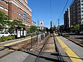
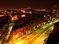
 AnsaldoBreda Type 8 #3840 attend à un feu rouge sur Commonwealth Avenue à Carlton Street. | |
| Réseau | Métro de Boston |
|---|---|
| Terminus | Boston College Station |
| Histoire | |
| Mise en service | |
| Exploitant | MBTA |
| Infrastructure | |
| Conduite (système) | Métro léger |
| Exploitation | |
| Matériel utilisé | Kinki Sharyo type 7 AnsaldoBreda type 8 |
| Points d’arrêt | 25 |
| Jours de fonctionnement | L, Ma, Me, J, V, S, D |
| modifier |
|
La Branche B de la ligne verte du métro de Boston, également appelé Branche de Commonwealth Avenue ou dbranche de Collège de Boston, est une branche de la Ligne verte de la Massachusetts Bay Transportation Authority dans la région de Boston. Cette ligne longe Commonwealth Avenue avec des véhicules légers sur rail. Après la descente de Blandford Street, les voies se joignent aux branches C et D à Kenmore Station.
Stations[modifier | modifier le code]
| Station | Localisation | Temps jusqu'à Park Street[1] |
Temps jusqu'à Boston College |
Correspondances et notes | |
|---|---|---|---|---|---|
| Blandford Street Station (en) | Commonwealth Avenue à Silber Way, Boston | 16 minutes | 27 minutes | ||
| Boston University East Station (en) | Commonwealth Avenue à Granby Street, Boston | 17 minutes | 26 minutes | ||
| Boston University Central Station (en) | Commonwealth Avenue à Marsh Chapel, Boston | 18 minutes | 25 minutes | ||
| Boston University West Station (en) | Commonwealth Avenue à Amory Street, Boston | 19 minutes | 24 minutes | ||
| St. Paul Street Station (en) | Commonwealth Avenue à Buick Street, Boston | 20 minutes | 23 minutes | ||
| Pleasant Street Station (en) | Commonwealth Avenue à Pleasant Street, Boston | 22 minutes | 21 minutes | ||
| Babcock Street Station (en) | Commonwealth Avenue à Babcock Street, Boston | 24 minutes | 19 minutes | ||
| Packards Corner Station (en) | Packard's Corner à Brighton Avenue, Allston | 26 minutes | 17 minutes | Lieu de divergence de la ligne verte | |
| Fordham Road | Commonwealth Avenue at Fordham Road | Plus d'arrêt | Fermée en 2005. | ||
| Harvard Avenue Station (en) | Commonwealth Avenue à Harvard Avenue, Allston | 28 minutes | 15 minutes | Bus 66 | |
| Griggs Street/Long Avenue Station (en) | Commonwealth Avenue à Griggs Street, Allston | 30 minutes | 13 minutes | ||
| Allston Street Station (en) | Commonwealth Avenue à Allston Street, Allston | 32 minutes | 11 minutes | ||
| Warren Street Station (en) | Commonwealth Avenue à Warren Street, Brighton | 34 minutes | 9 minutes | ||
| Summit Avenue | Commonwealth Avenue à Summit Avenue, Brighton | No longer a stop | Fermée en 2005. | ||
| Washington Street Station (en) | Commonwealth Avenue at Washington Street, Brighton | 36 minutes | 7 minutes | Bus 65 à Kenmore Square | |
| Mount Hood Road | Commonwealth Avenue à Mount Hood Road, Brighton | Plus d'arrêt | fermée en 2005. | ||
| Sutherland Street Station (en) | Commonwealth Avenue à Sutherland Road, Brighton | 38 minutes | 5 minutes | ||
| Chiswick Road Station (en) | Commonwealth Avenue à Chiswick Road, Brighton | 40 minutes | 3 minutes | ||
| Chestnut Hill Avenue Station (en) | Commonwealth Avenue at Chestnut Hill Avenue, Brighton | 41 minutes | 2 minutes | marche à pied vers Cleveland Circle (branche C) et Reservoir (branche D) | |
| South Street Station (en) | Commonwealth Avenue à South Street, Brighton | 42 minutes | 1 minute | ||
| Greycliff Road | Commonwealth Avenue à Greycliff Road, Brighton | plus d'arrêt | fermée en 2005. | ||
| Boston College Station (en) | Commonwealth Avenue à Lake Street, Chestnut Hill, Boston desservant Boston College | 43 minutes | 0 minutes | Lake Street | |
Stations en photos[modifier | modifier le code]
-
 Blandford Street station
 -
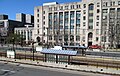
 Boston University East Station
 -
 Boston University Central Station
 -
 Boston University West Station
 -
 St. Paul Street Station
 -
 Pleasant Street Station
 -
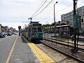 Babcock Street Station
 -
 Harvard Avenue Station
 -
 Allston Street Station
 -
 Warren Street Station
 -
 Washington Street Station
 -
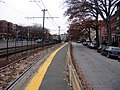
 Sutherland Road Station
 -
 Chestnut Hill Avenue Station
 -
 South Street Station
 -
 Boston College Station


Notes et références[modifier | modifier le code]
- Association for Public Transportation, Car-Free in Boston, A Guide for Locals and Visitors, 10th ed. (2003), p. 117.