Shelburne (municipalité de district de la Nouvelle-Écosse)
| Shelburne | ||
| Administration | ||
|---|---|---|
| Pays | ||
| Province | ||
| Région | Comté de Shelburne | |
| Statut municipal | Municipalité de district | |
| Démographie | ||
| Population | 4 828 hab. (226) | |
| Densité | 2,7 hab./km2 | |
| Géographie | ||
| Coordonnées | 43° 51′ 00″ nord, 65° 16′ 58″ ouest | |
| Superficie | 181 849 ha = 1 818,49 km2 | |
| Divers | ||
| Code géographique | 1201006 | |
| Localisation | ||
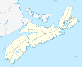
| Géolocalisation sur la carte : Nouvelle-Écosse
| ||
| Liens | ||
| Site web | www.municipalityofshelburne.ca | |
| modifier |
||
Shelburne est une municipalité de district du Comté de Shelburne en Nouvelle-Écosse au Canada.
Démographie[modifier | modifier le code]

Communautés[modifier | modifier le code]
Le district municipal de Shelburne comprend plusieurs communautés.
- Allendale
- Arnold
- Atlantic
- Birchtown
- Blanche
- Carleton Village
- Churchover
- Clyde River
- East Green Harbour
- East Jordan
- East Sable River
- East Side of Ragged Island
- Granite Village
- Greenwood
- Gunning Cove
- Ingomar
- Jordan Bay
- Jordan Branch
- Jordan Falls
- Jordan Ferry
- Little Harbour
- Little Port L'Hebert
- Lockeport
- Lockeport Station
- Louis Head
- Lower Jordan Bay
- Lower Ohio
- Lower Sandy Point
- Lydgate
- McNutts Island
- Middle Ohio
- North East Harbour
- North West Harbour
- Ohio
- Osborne Harbour
- Pleasant Point
- Port Clyde
- Port L'Hebert
- Port Saxon
- Rockland
- Roseway
- Round Bay
- Sable River
- Sable River Station
- Sable River West
- Sandy Point
- Shelburne
- Upper Clyde River
- Upper Ohio
- Welshtown
- West Green Harbour
- West Middle Sable
- Western Head
Références[modifier | modifier le code]
- (en) Cet article est partiellement ou en totalité issu de l’article de Wikipédia en anglais intitulé « Municipality of the District of Shelburne » (voir la liste des auteurs).
- « Statistique Canada - Profils des communautés de 2006 - Shelburne » (consulté le )
- « Statistique Canada - Profils des communautés de 2016 - Shelburne » (consulté le )


