
Fichier:Rzeczpospolita Rozbiory 2.png

Taille de cet aperçu : 727 × 599 pixels. Autres résolutions : 291 × 240 pixels | 582 × 480 pixels | 932 × 768 pixels | 1 242 × 1 024 pixels | 1 902 × 1 568 pixels.
Fichier d’origine (1 902 × 1 568 pixels, taille du fichier : 296 kio, type MIME : image/png)
Ce fichier et sa description proviennent de Wikimedia Commons.
Description

|
Cette image (de type historical map) devrait être recréée dans un format vectoriel, en tant que fichier SVG. Cela offrirait plusieurs avantages : voir Commons:Media for cleanup pour plus d'informations. Si une version SVG de cette image est déjà disponible, merci de bien vouloir l'envoyer. Après cela, remplacez ce modèle par {{vector version available|nouveau nom d'image.svg}}.
|
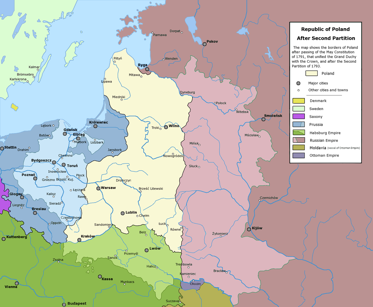
Poland after the Second Partition.
Conditions d’utilisation
The following is a list of maps created by Halibutt and uploaded to commons, as well as their present and projected derivatives.
| Parent Image | Image | Description | |||||||||||
|---|---|---|---|---|---|---|---|---|---|---|---|---|---|
| Maps by Halibutt | |||||||||||||
| Image:Rzeczpospolita.png | Image:Rzeczpospolita.png | The Republic in 17th and 18th century | |||||||||||
| Image:Rzeczpospolita 1600.png | The Republic after the Treaty of Dywilino | ||||||||||||
| Image:Rzeczpospolita voivodships.png | Voivodships of The Republic | ||||||||||||
| Image:Rzeczpospolita_Potop.png | The Republic during The Deluge and Chmielnicki Uprising, with major battles of the era marked | ||||||||||||
| Magnates and their lands and domains | |||||||||||||
| 1st • 2nd • 3rd | Partitions of Poland | ||||||||||||
| War of the constitution | |||||||||||||
| Image:Rzeczpospolita.xcf | SOURCE FILE - GIMP format | ||||||||||||
| Image:Poland 1939.png | Image:Poland 1939.png | Poland in 1939 | |||||||||||
| Image:Dywizje wrzesien 1.png | Order of Battle on September 1st, during the Polish Defence War of 1939 | ||||||||||||
| Image:Poland 1939.xcf | SOURCE FILE - GIMP format | ||||||||||||
| Image:Polska kontur bialy.png | Image:Polska kontur bialy.png | Contour map of Poland AD 1999, for use with various locator maps | |||||||||||
| Image:Rzeczpospolita 1923.png | Image:Rzeczpospolita 1923.png | Map of Poland 1918-1939, currently under development | |||||||||||
| Image:PBW March 1919.png | Polish-Bolshevik War - fronts in March of 1919 | ||||||||||||
| Image:PBW December 1919.png | Polish-Bolshevik War - fronts in December of 1919 | ||||||||||||
| Image:PBW June 1920.png | Polish-Bolshevik War - fronts in July of 1920 | ||||||||||||
| Image:PBW August 1920.png | Polish-Bolshevik War - fronts in August of 1920 | ||||||||||||
| Polish Defence War of 1939 | |||||||||||||
| Polish areas annexed by Germany, Lithuania, Slovakia and the Soviet Union | |||||||||||||
| German concentration camps in Poland | |||||||||||||
| Curzon line | |||||||||||||
| Major battles of the Polish-Bolshevik War | |||||||||||||
| names • no names | Polish/Czechoslovak/Lithuanian/German/Ukrainian claims in 1920's | ||||||||||||
| Image:Rzeczpospolita Central Lithuania.png | Central Lithuania | ||||||||||||
| Image:Rzeczpospolita Lithuania claims.png | Central Lithuania as compared with other Lithuanian claims | ||||||||||||
| Image:Rzeczpospolita 1789-1920.png | Post-1922 borders compared with the territory of Poland before the partitions | ||||||||||||
| Warsaw Uprising and the Operation Tempest | |||||||||||||
| Poland partitioned between the Soviets and the Germans | |||||||||||||
| Image:Rzeczpospolita 1939 Polish divisions.png | Polish divisions on September 1, 1939 | ||||||||||||
| Home Army inspectorates | |||||||||||||
| Image:Rzeczpospolita 1922.xcf | SOURCE FILE - GIMP format | ||||||||||||
| Image:Rzeczpospolita 1937.svg | Vector version!!!! | layered version available on request | |||||||||||
Since the legal status of the above comment has been questioned, I hereby grant anyone the right to treat it as either a standard copyright notice, invariant section, legal statement, legal advice, friendly suggestion or a mere comment, depending on his or hers own choice. |
|

Historique du fichier
Cliquer sur une date et heure pour voir le fichier tel qu'il était à ce moment-là.
| Date et heure | Vignette | Dimensions | Utilisateur | Commentaire | |
|---|---|---|---|---|---|
| actuel | 6 janvier 2018 à 05:55 | | 1 902 × 1 568 (296 kio) | Alphathon | General cleanup |
| 18 juillet 2016 à 21:28 |  | 1 902 × 1 568 (332 kio) | Poeticbent | further correction for vision impared | |
| 18 juillet 2016 à 18:20 |  | 1 902 × 1 568 (331 kio) | Poeticbent | adjust to match others | |
| 18 juillet 2016 à 18:14 |  | 1 902 × 1 568 (331 kio) | Poeticbent | per en:Talk:Partitions of Poland - accessibility for people with color vision impairment, dead space cropped | |
| 6 mai 2016 à 16:43 |  | 2 000 × 1 568 (213 kio) | Julieta39 | Cosmetic changes according with the sources cited in the discussion page of this day. | |
| 24 février 2010 à 16:44 |  | 2 000 × 1 568 (195 kio) | Dcoetzee | Remove watermark, pngcrush | |
| 31 janvier 2009 à 03:30 |  | 2 000 × 1 568 (281 kio) | Mareklug | corrected mistake: legend color for H. Empire was off color (not green but white) | |
| 16 février 2006 à 22:53 |  | 2 000 × 1 568 (281 kio) | Tomekpe | Corrected mistakes: * Silesia at the time belonged to Prussia, whereas the map shows it belonging to Austria. * Sweden no longer had Estonia. * Denmark no longer had the island off the coast of Estonia. * The Ottoman Empire did not control Hungary and Mo | |
| 25 décembre 2005 à 23:31 |  | 2 000 × 1 568 (284 kio) | Tomekpe | Halibutt's graphic with changing polish-russian border (Krasny Horodok area). Also deleted white rectangle. | |
| 10 janvier 2005 à 15:41 |  | 2 000 × 1 568 (286 kio) | Halibutt | Poland after the 2nd Partition<br>{{User:Halibutt/maps}}<br>{{User:Halibutt/GFDL}}<br>Category:Maps of Poland<br>Category:Historical maps |
Utilisation du fichier
Les 7 pages suivantes utilisent ce fichier :
Usage global du fichier
Les autres wikis suivants utilisent ce fichier :
- Utilisation sur ar.wikipedia.org
- Utilisation sur azb.wikipedia.org
- Utilisation sur be-tarask.wikipedia.org
- Utilisation sur be.wikipedia.org
- Utilisation sur bg.wikipedia.org
- Utilisation sur br.wikipedia.org
- Utilisation sur ca.wikipedia.org
- Utilisation sur cs.wikipedia.org
- Utilisation sur de.wikipedia.org
- Utilisation sur dsb.wikipedia.org
- Utilisation sur el.wikipedia.org
- Utilisation sur en.wikipedia.org
- Utilisation sur es.wikipedia.org
- Utilisation sur et.wikipedia.org
- Utilisation sur fa.wikipedia.org
- Utilisation sur fi.wikipedia.org
- Utilisation sur gl.wikipedia.org
- Utilisation sur hr.wikipedia.org
- Utilisation sur hu.wikipedia.org
- Utilisation sur hy.wikipedia.org
- Utilisation sur id.wikipedia.org
Voir davantage sur l’utilisation globale de ce fichier.