Aller au contenu

Fichier:Decision Support System for John Day Reservoir.jpg

Le contenu de la page n’est pas pris en charge dans d’autres langues.
Une page de Wikipédia, l'encyclopédie libre.

Decision_Support_System_for_John_Day_Reservoir.jpg (477 × 364 pixels, taille du fichier : 178 kio, type MIME : image/jpeg)

Ce fichier et sa description proviennent de Wikimedia Commons.

Description

Description
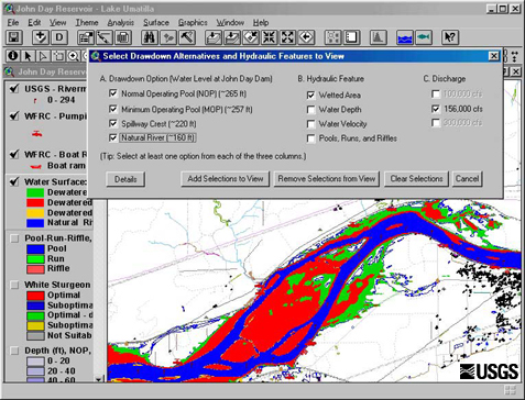
English: This set of tools, in conjunction with 2-dimensional hydraulic modeling, is being used to estimate the effects of reservoir level and water discharge fluctuations on aquatic and terrestrial habitats in John Day Reservoir. Different scenarios being studied now range from typical reservoir levels at high and low discharges to a simulation of what things might be like if the river were to return to natural conditions
Date Retrieved June 17 2009.
Source http://wfrc.usgs.gov/research/geospatial%20studies/STGeospat4.htm ...returns HTTP status 404. The most recent non-404 snapshot of this page from archive.org is: https://web.archive.org/web/20100527105316/http://wfrc.usgs.gov/research/geospatial%20studies/STGeospat4.htm
Auteur USGS: Project contact Michael J. Parsley, U.S. Geological Survey

Conditions d’utilisation

Public domain
Cette image est placée dans le domaine public parce qu'elle contient des éléments issus de l'United States Geological Survey, une agence du Département de l'Intérieur des États-Unis. Pour plus d'information, consultez la politique officielle de copyright de l'USGS (en anglais)

Bahasa Indonesia  català  čeština  Deutsch  eesti  English  español  français  galego  italiano  Nederlands  português  polski  sicilianu  suomi  Tiếng Việt  Türkçe  български  македонски  русский  മലയാളം  한국어  日本語  中文  中文(简体)  中文(繁體)  العربية  فارسی  +/−

Légendes

Ajoutez en une ligne la description de ce que représente ce fichier

Éléments décrits dans ce fichier

dépeint

182 212 octet

364 pixel

477 pixel

image/jpeg

4a73bf3fdc55a87744768b3e7e4b2a0f198588f0

Historique du fichier

Cliquer sur une date et heure pour voir le fichier tel qu'il était à ce moment-là.

Date et heureVignetteDimensionsUtilisateurCommentaire
actuel17 juin 2009 à 12:40Vignette pour la version du 17 juin 2009 à 12:40477 × 364 (178 kio)Mdd{{Information |Description={{en|1=This set of tools, in conjunction with 2-dimensional hydraulic modeling, is being used to estimate the effects of reservoir level and water discharge fluctuations on aquatic and terrestrial habitats in John Day Reservoir.

Usage global du fichier

Les autres wikis suivants utilisent ce fichier :

Métadonnées