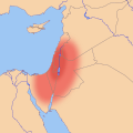
Fichier:Southern Levant map.svg

Le contenu de la page n’est pas pris en charge dans d’autres langues.
Une page de Wikipédia, l'encyclopédie libre.

Fichier d’origine(Fichier SVG, nominalement de 524 × 524 pixels, taille : 418 kio)

Ce fichier et sa description proviennent de Wikimedia Commons.

Description

Description
English: Location map of the en:Southern Levant, based on an approximate, geographic definition:
  • "The southern Levant, as defined here, is delimited by the Litani River to the north, the Jordan Rift Valley to the East, the Gulf of Aqaba to the south, and the Mediterranean Sea and Sinai Desert to the west."[1]
  • "The region defined as the Southern Levant encompasses the territory crossed by the valleys of the Litani and Jordan, including the Mediterranean littoral extending from Lebanon to northern Sinai. Moreover, the Negev, the Sinai peninsula and Jordan are considered parts of this vast region."[2]
  • "The southern Levant refers to all of the territory south of the headwaters of the Orontes River and west of the Syrian Desert"[3]

Legend

  Core area of the Southern Levant
  Other regions sometimes included in the Southern Levant

References

  1. Peregrine, Peter N. (2003) Encyclopedia of Prehistory: Volume 8: South and Southwest Asia, Springer Science & Business Media, pp. 86 ISBN : 9780306462627.
  2. Yakar, Jak (1998). "The socio-economic structure of prehistoric communities in the Southern Levant, ca. 13000-8000 BP". Documenta Praehistorica XXV.
  3. Routledge, Bruce (2004) Moab in the Iron Age: Hegemony, Polity, Archaeology, University of Pennsylvania Press, pp. 223 ISBN : 081223801X.
Date
Source Travail personnel
Auteur Joe Roe

Conditions d’utilisation

Moi, en tant que détenteur des droits d’auteur sur cette œuvre, je la publie sous la licence suivante :
w:fr:Creative Commons
paternité partage à l’identique
Vous êtes libre :
  • de partager – de copier, distribuer et transmettre cette œuvre
  • d’adapter – de modifier cette œuvre
Sous les conditions suivantes :
  • paternité – Vous devez donner les informations appropriées concernant l'auteur, fournir un lien vers la licence et indiquer si des modifications ont été faites. Vous pouvez faire cela par tout moyen raisonnable, mais en aucune façon suggérant que l’auteur vous soutient ou approuve l’utilisation que vous en faites.
  • partage à l’identique – Si vous modifiez, transformez, ou vous basez sur cette œuvre, vous devez distribuer votre contribution sous la même licence ou une licence compatible avec celle de l’original.

Légendes

Ajoutez en une ligne la description de ce que représente ce fichier

Éléments décrits dans ce fichier

dépeint

Historique du fichier

Cliquer sur une date et heure pour voir le fichier tel qu'il était à ce moment-là.

Date et heureVignetteDimensionsUtilisateurCommentaire
actuel2 août 2016 à 16:32Vignette pour la version du 2 août 2016 à 16:32524 × 524 (418 kio)Joe RoeTweaked ranges per en:Talk:Southern Levant#Maps
26 juillet 2016 à 23:05Vignette pour la version du 26 juillet 2016 à 23:05524 × 524 (416 kio)Joe RoeDifferentiated "core" and "inclusive" definitions
26 juillet 2016 à 20:41Vignette pour la version du 26 juillet 2016 à 20:41524 × 524 (391 kio)Joe RoeUser created page with UploadWizard

La page suivante utilise ce fichier :

Usage global du fichier

Les autres wikis suivants utilisent ce fichier :

Métadonnées