
Fichier:Map of the Grand Duchy of Lithuania (pink) and the Crown of the Kingdom of Poland (red) and its neighborhood in 1386 – 1434 (English version).png

Taille de cet aperçu : 609 × 599 pixels. Autres résolutions : 244 × 240 pixels | 488 × 480 pixels | 781 × 768 pixels | 1 041 × 1 024 pixels | 2 082 × 2 048 pixels | 2 977 × 2 929 pixels.
Fichier d’origine (2 977 × 2 929 pixels, taille du fichier : 2,13 Mio, type MIME : image/png)
Ce fichier et sa description proviennent de Wikimedia Commons.
_and_the_Crown_of_the_Kingdom_of_Poland_(red)_and_its_neighborhood_in_1386_%E2%80%93_1434_(English_version).png?uselang=fr)
Description
| Description |
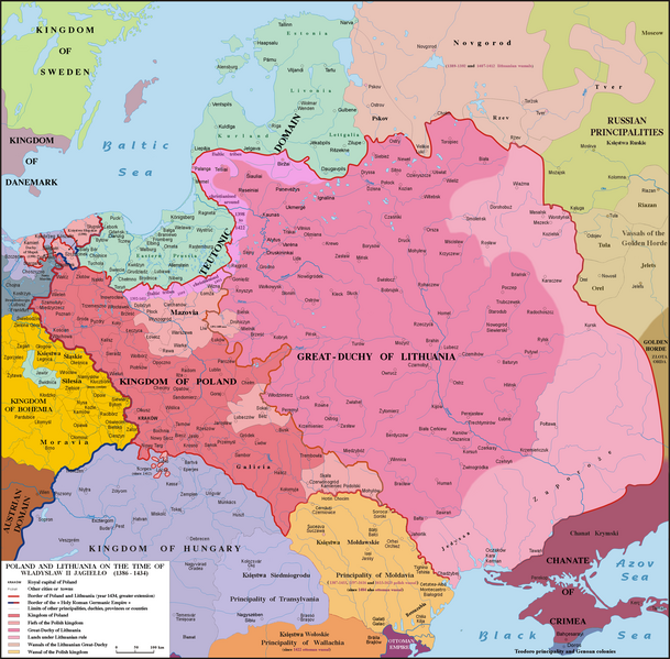
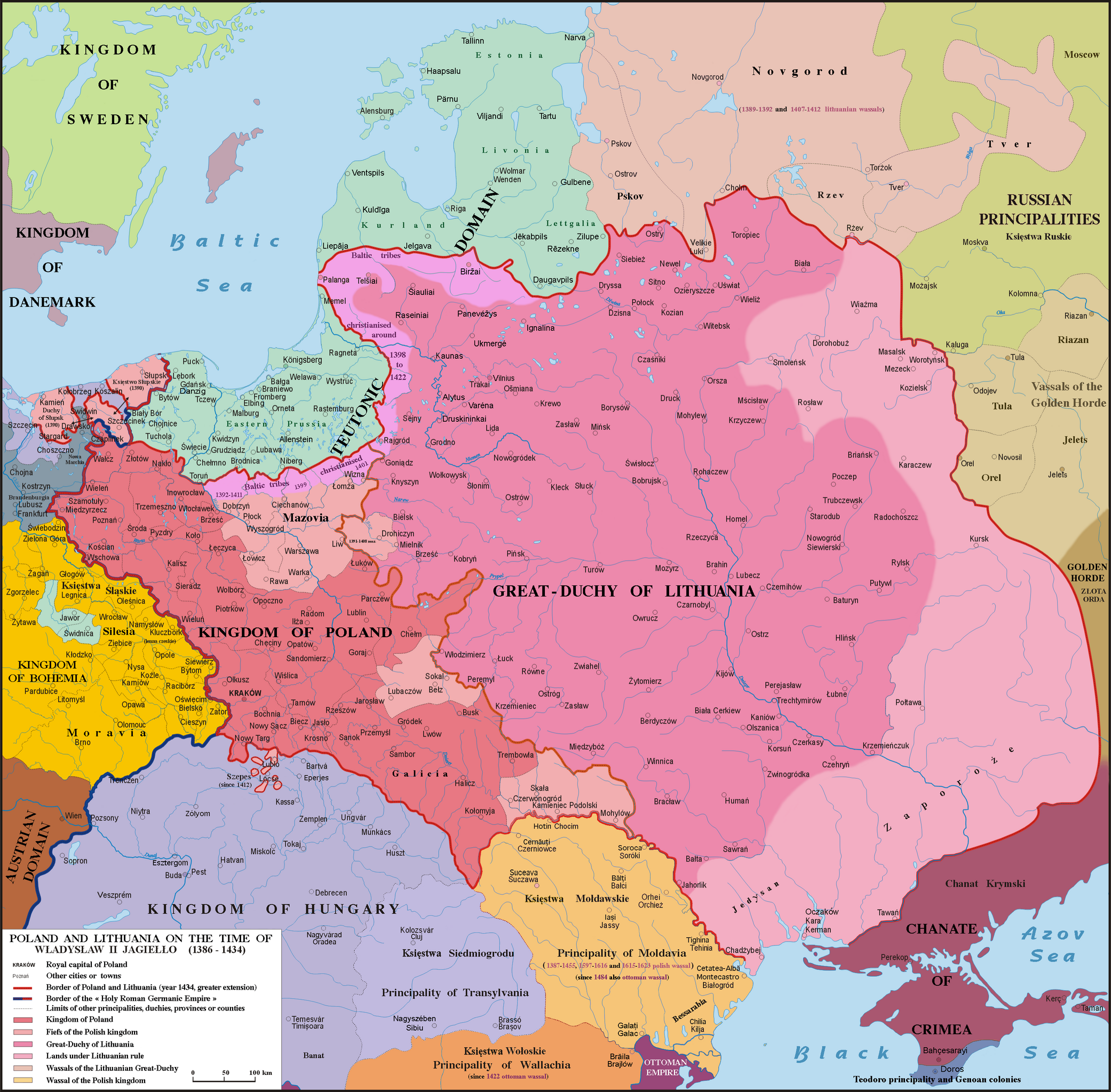
English: Map of Poland, Lithuania & neighbourough 1386-1434. Graphic derivative map since https://fr.wikipedia.org/wiki/Yedisan#/media/File:Polska_1386_-_1434.png but English version and without the 5 mistakes of the original map (impossible to be corrected because the first uploader reverts the new versions) : 1)- Moldavia wasn't a province or a fief (lenno in polish) of the Polish kingdom, but a principality, vassal of Poland from 1387 to 1455, from 1597 to 1616 & from 1615 to 1623 : the Moldavian prince were not a Polish sir appointed by the polish King but a Moldavian boyard elected by the Moldavian Sfat ; 2)- The name Hospodar for the Moldavian princes aren’t in use before the XVIth century ; 3)- In this time Kilja was on the south side of Chilia arm (today Chilia Veche in Romania, not the new Kilija in Ukraine) ; 4)- Danube delta was moldavian till 1484 and the shoreline was different in 1400 ; 5)- Akkerman is not another town but the turkish name (given since 1484) of Bialgorod also named in this time Cetatea-Alba & Montecastro. Sources: Hans-Erich Stier (dir.) "Grosser Atlas zur Weltgeschichte", Ed. Westermann 1985, ISBN 3-14-100919-8, "Történelmi atlasz", Magyar Academy 1991, ISBN 963-351422-3 CM, "Atlas istorico-geografic", Ed. Academica 1994, ISBN 973-27-0500-0, Constantin C. Giurescu & Dinu C. Giurescu :" History of the Romanian lands", Ed. Academica 1985, p.209-210, N. P. Comneanu: "Les principautés roumaines à travers les âges", Ed. Payot, Paris 1919 and Lucian Predescu: "Enciclopedia Cugetarea", p.562-563.
Lietuvių: Lietuvos Didžiosios Kunigaikštystės (rožinė) ir Lenkijos Karalystės Karūnos (raudona) žemėlapis valdant Jogailai 1386 - 1434 m.
Polski: Mapa Polski i Litwy za panowania Władysława II Jagiełły (1386 - 1434). |
| Date | |
| Source | File:Polska 1386 - 1434.png |
| Auteur |
Poznaniak (original image) Spiridon Ion Cepleanu (derivative work) |
Conditions d’utilisation
Moi, en tant que détenteur des droits d’auteur sur cette œuvre, je la publie sous la licence suivante :
Ce fichier est sous la licence Creative Commons Attribution – Partage dans les Mêmes Conditions 4.0 International.
- Vous êtes libre :
- de partager – de copier, distribuer et transmettre cette œuvre
- d’adapter – de modifier cette œuvre
- Sous les conditions suivantes :
- paternité – Vous devez donner les informations appropriées concernant l'auteur, fournir un lien vers la licence et indiquer si des modifications ont été faites. Vous pouvez faire cela par tout moyen raisonnable, mais en aucune façon suggérant que l’auteur vous soutient ou approuve l’utilisation que vous en faites.
- partage à l’identique – Si vous modifiez, transformez, ou vous basez sur cette œuvre, vous devez distribuer votre contribution sous la même licence ou une licence compatible avec celle de l’original.
Historique du fichier
Cliquer sur une date et heure pour voir le fichier tel qu'il était à ce moment-là.
| Date et heure | Vignette | Dimensions | Utilisateur | Commentaire | |
|---|---|---|---|---|---|
| actuel | 10 mai 2016 à 19:18 | | 2 977 × 2 929 (2,13 Mio) | Julieta39 | Teodoro principality in Crimea until 1475 |
| 6 décembre 2015 à 18:11 |  | 2 977 × 2 929 (2,14 Mio) | Spiridon Ion Cepleanu | Correct orthograph of Lithuania in english | |
| 6 décembre 2015 à 15:56 |  | 2 977 × 2 929 (2,14 Mio) | Spiridon Ion Cepleanu | User created page with UploadWizard |
Utilisation du fichier
Les 8 pages suivantes utilisent ce fichier :
Usage global du fichier
Les autres wikis suivants utilisent ce fichier :
- Utilisation sur af.wikipedia.org
- Utilisation sur als.wikipedia.org
- Utilisation sur ar.wikipedia.org
- Utilisation sur az.wikipedia.org
- Utilisation sur be.wikipedia.org
- Utilisation sur bg.wikipedia.org
- Utilisation sur br.wikipedia.org
- Utilisation sur ca.wikipedia.org
- Utilisation sur cs.wikipedia.org
- Utilisation sur da.wikipedia.org
- Utilisation sur de.wikipedia.org
- Utilisation sur de.wikibooks.org
- Utilisation sur de.wikiversity.org
- Utilisation sur el.wikipedia.org
- Utilisation sur en.wikipedia.org
- Utilisation sur et.wikipedia.org
- Utilisation sur fa.wikipedia.org
- Utilisation sur fi.wikipedia.org
- Utilisation sur gd.wikipedia.org
- Utilisation sur hu.wikipedia.org
- Utilisation sur it.wikipedia.org
- Utilisation sur ja.wikipedia.org
- Utilisation sur lt.wikipedia.org
- Utilisation sur lt.wikibooks.org
- Utilisation sur lv.wikipedia.org
- Utilisation sur sl.wikipedia.org
_and_the_Crown_of_the_Kingdom_of_Poland_(red)_and_its_neighborhood_in_1386_–_1434_(English_version).png)