
Fichier:Southeastern Europe, late 9th century.jpg
Pas de plus haute résolution disponible.
Southeastern_Europe,_late_9th_century.jpg (602 × 429 pixels, taille du fichier : 365 kio, type MIME : image/jpeg)
Ce fichier et sa description proviennent de Wikimedia Commons.
Description
| Description |
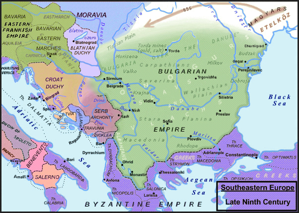
English: Southeastern Europe, late 9th century. |
||
| Date | |||
| Source |
Slavistic map, derivative from File:Balkan_9_vek.png enriched with the religious minorities & corrected following: [1]; [2]; Dragan Veselinov Manchov's works (1834-1908) synthetised here: File:Bulgaria-Iván_Asen-es.svg and [3]; Roman Kovalev, (ed.), The Other Europe in the Middle Ages: Avars, Bulgars, Khazars and Cumans, Brill, pp. 151–236. ISBN 978-90-04-16389-8; H.-E. Stier (dir.) Westermann grosser Atlas zur Weltgeschichte, Braunschweig 1985, ISBN 3-14-100919-8, pp. 64, 65, 70 & 88; Francis Conte, Les Slaves, coll. Bibliothèque de l'Évolution de l'Humanité, Albin Michel, 1996, p. 91-96; P. M. Barford, The Early Slavs. Culture and Society in Early Medieval Eastern Europe, ISBN 0-8014-3977-9; John Fine, Jr., The Early Medieval Balkans, ISBN 0 472 081497; Jean W. Sedlar, East Central Europe in the Middle Ages, 1000–1500, University of Washington Press, 2011 ISBN 0-295-97291-2; D. Hupchik, The Balkans. From Constantinople to Communism; Ian Mladjov, “Trans‐Danubian Bulgaria: Reality and Fiction“, in Byzantine Studies n.s. 3, 1998 [2000], 85–128;; Victor Spinei, The Romanians and the Turkic Nomads North of the Danube Delta from the Tenth to the Mid-Thirteenth century, Koninklijke Brill 2009, ISBN 978-90-04-17536-5. |
||
| Auteur | Moodylo333 | ||
| Autorisation (Réutilisation de ce fichier) |
|
||
| Autres versions | File:Balkan_9_vek.png, according with the Hungarian point of view, where the Slavic principality of Blatnograd is confused with the antic Pannonia, the river Dniester is confused with the Prut river, the Aegean islands are already Genoese five centuries in advance, and the "Bulgarian lands across the Danube" (on the northern side) are minimized, with precise borders, when in reality they were often fluctuant; this area is represented without the Bulgarian control on the gold, copper and salt mines in Transylvania (also exploited on the Dacian and Roman times) and without inhabitants, because the hungarian official point of view needs that there was no population in Transylvania before the Magyars, neither Slavic nor Romance. |
![[3]](https://fr.wikipedia.org/wiki/Second_Empire_bulgare#/media/Fichier:Bulgaria-Iv%C3%A1n_Asen2-es.svg)
Conditions d’utilisation
Moi, en tant que détenteur des droits d’auteur sur cette œuvre, je la publie sous la licence suivante :
| Ce fichier est disponible selon les termes de la licence Creative Commons CC0 Don universel au domaine public. | |
| La personne qui a associé une œuvre avec cet acte l’a placée dans le domaine public en renonçant mondialement à tous ses droits sur cette œuvre en vertu des lois relatives au droit d’auteur, ainsi qu’à tous les droits juridiques connexes et voisins qu’elle possédait sur l’œuvre, sans autre limite que celles imposées par la loi. Vous pouvez copier, modifier, distribuer et utiliser cette œuvre, y compris à des fins commerciales, sans qu’il soit nécessaire d’en demander la permission.
|
Historique du fichier
Cliquer sur une date et heure pour voir le fichier tel qu'il était à ce moment-là.
| Date et heure | Vignette | Dimensions | Utilisateur | Commentaire | |
|---|---|---|---|---|---|
| actuel | 30 décembre 2023 à 11:41 | | 602 × 429 (365 kio) | Moodylo333 | Uploaded own work with UploadWizard |
Utilisation du fichier
Les 4 pages suivantes utilisent ce fichier :