
Fichier:Esteros del Iberá.jpg
Taille de cet aperçu : 800 × 530 pixels. Autres résolutions : 320 × 212 pixels | 640 × 424 pixels | 1 024 × 678 pixels | 1 280 × 847 pixels | 2 183 × 1 445 pixels.
Fichier d’origine (2 183 × 1 445 pixels, taille du fichier : 1 Mio, type MIME : image/jpeg)
Ce fichier et sa description proviennent de Wikimedia Commons.
Description
| Description |
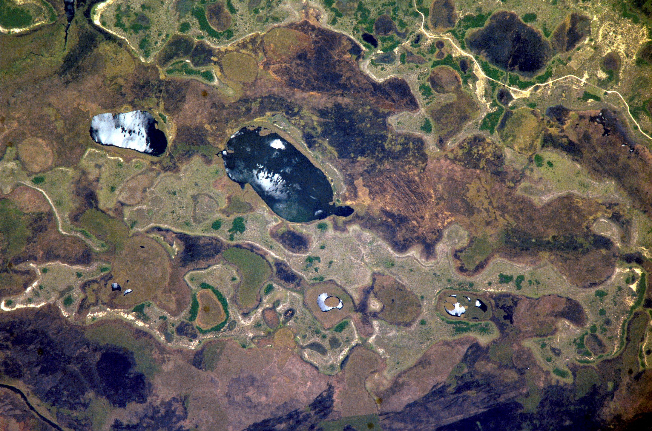
English: Ibera Wetlands, province of Corrientes, Argentina, one of the largest wetland areas in South America (the second largest after Brazil's Pantanal). Picture taken from the International Space Station.
Español: Esteros del Iberá, provincia de Corrientes, Argentina, uno de los más grandes humedales de Sudamérica (el segundo en tamaño después del Pantanal en Brasil). Foto tomada desde la Estación Espacial Internacional. |
| Date | Prise le 25 octobre 2004 |
| Source | http://spaceflight.nasa.gov/gallery/images/station/crew-10/html/iss010e05072.html |
| Auteur | NASA |
Cette image ou vidéo a été cataloguée par le Johnson Space Center de la National Aeronautics and Space Administration (NASA) des États-Unis sous Photo ID : ISS010-E-05072.Ce bandeau n’indique rien sur le statut de l’œuvre au regard du droit d'auteur. Un bandeau de droit d’auteur est requis. Voir Commons:À propos des licences pour plus d’informations. Autres langues :
|
Conditions d’utilisation
"The Gateway to Astronaut Photography of Earth". Image provenant du Laboratoire d'Analyse et d'Imagerie des Sciences, Centre Spatial Johnson de la NASA.
Source de la photo : ISS010-E-05072.
|
Historique du fichier
Cliquer sur une date et heure pour voir le fichier tel qu'il était à ce moment-là.
| Date et heure | Vignette | Dimensions | Utilisateur | Commentaire | |
|---|---|---|---|---|---|
| actuel | 26 décembre 2017 à 22:02 | | 2 183 × 1 445 (1 Mio) | Ras67 | high resolution |
| 10 février 2006 à 12:12 |  | 640 × 423 (118 kio) | Pablo-flores | '''es:''' Esteros del Iberá, provincia de Corrientes, Argentina, uno de los más grandes humedales de Sudamérica (el segundo en tamaño después del Pantanal en Brasil). Foto tomada desde la Estación Espacial Internacional. '''en:''' Ibera Wetland |
Utilisation du fichier
La page suivante utilise ce fichier :
Usage global du fichier
Les autres wikis suivants utilisent ce fichier :
- Utilisation sur bs.wikipedia.org
- Utilisation sur de.wikipedia.org
- Utilisation sur en.wikipedia.org
- Utilisation sur eo.wikipedia.org
- Utilisation sur es.wikipedia.org
- Utilisation sur eu.wikipedia.org
- Utilisation sur it.wikipedia.org
- Utilisation sur no.wikipedia.org
- Utilisation sur pt.wikipedia.org
- Utilisation sur zh.wikipedia.org