
Fichier:Afsluitdijk Netherlands Satellite Photo by Sentinel-2 30 June 2018.jpg

Fichier d’origine (4 305 × 3 847 pixels, taille du fichier : 12,89 Mio, type MIME : image/jpeg)
Ce fichier et sa description proviennent de Wikimedia Commons.
Description
| Description |
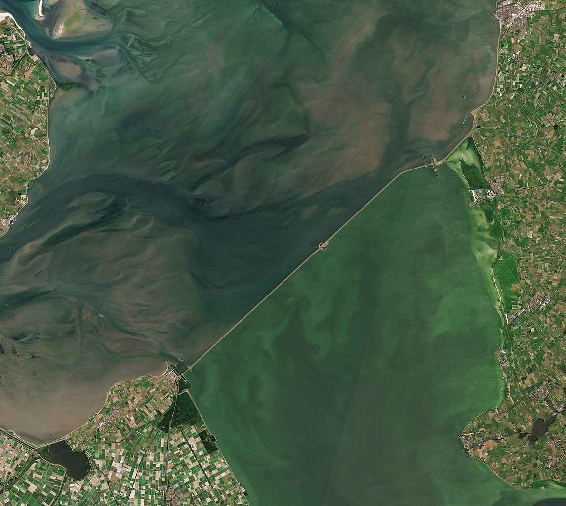
English: A satellite photo of the Afsluitdijk, The Netherlands, 30 June 2018. The Afsluitdijk changed the Zuiderzee into the IJsselmeer. To the north of the Afsluitdijk is the Wadden Sea, to the south is the IJsselmeer. Sensor: MSI on Sentinel-2A. Resolution: 10m. RGB Composites: True color, Band 4-3-2.
Nederlands: Een satellietfoto van de Afsluitdijk, Nederland, 30 juni 2018. De afsluitdijk veranderde de Zuiderzee in het IJsselmeer. Ten noorden van de Afsluitdijk is de Waddenzee, ten zuiden is het IJsselmeer. Sensor: MSI op Sentinel-2A. Resolutie: 10m. RGB-composieten: Ware Kleuren, Band 4-3-2. |
| Date | |
| Source | |
| Auteur | Copernicus Sentinel-2, ESA |
.jpg)
Conditions d’utilisation
- Vous êtes libre :
- de partager – de copier, distribuer et transmettre cette œuvre
- d’adapter – de modifier cette œuvre
- Sous les conditions suivantes :
- paternité – Vous devez donner les informations appropriées concernant l'auteur, fournir un lien vers la licence et indiquer si des modifications ont été faites. Vous pouvez faire cela par tout moyen raisonnable, mais en aucune façon suggérant que l’auteur vous soutient ou approuve l’utilisation que vous en faites.
- partage à l’identique – Si vous modifiez, transformez, ou vous basez sur cette œuvre, vous devez distribuer votre contribution sous la même licence ou une licence compatible avec celle de l’original.

|
This image contains data from a satellite in the Copernicus Programme, such as Sentinel-1, Sentinel-2 or Sentinel-3. Attribution is required when using this image.
Attribution: Contains modified Copernicus Sentinel data 2018
The use of Copernicus Sentinel Data is regulated under EU law (Commission Delegated Regulation (EU) No 1159/2013 and Regulation (EU) No 377/2014). Relevant excerpts:
Free access shall be given to GMES dedicated data [...] made available through GMES dissemination platforms [...].
Access to GMES dedicated data [...] shall be given for the purpose of the following use in so far as it is lawful:
GMES dedicated data [...] may be used worldwide without limitations in time.
GMES dedicated data and GMES service information are provided to users without any express or implied warranty, including as regards quality and suitability for any purpose. |
Historique du fichier
Cliquer sur une date et heure pour voir le fichier tel qu'il était à ce moment-là.
| Date et heure | Vignette | Dimensions | Utilisateur | Commentaire | |
|---|---|---|---|---|---|
| actuel | 4 juillet 2023 à 09:27 | | 4 305 × 3 847 (12,89 Mio) | Artanisen | Uploaded a work by Copernicus Sentinel-2, ESA from Extracted from: North Holland with parts of Friesland and Flevoland by Sentinel-2 (Original 10m Res).jpg with UploadWizard |
Utilisation du fichier
La page suivante utilise ce fichier :
Usage global du fichier
Les autres wikis suivants utilisent ce fichier :
- Utilisation sur af.wikipedia.org
- Utilisation sur arz.wikipedia.org
- Utilisation sur ast.wikipedia.org
- Utilisation sur ca.wikipedia.org
- Utilisation sur cs.wikipedia.org
- Utilisation sur de.wikipedia.org
- Utilisation sur en.wikipedia.org
- Utilisation sur eo.wikipedia.org
- Utilisation sur es.wikipedia.org
- Utilisation sur fy.wikipedia.org
- Utilisation sur hu.wikipedia.org
- Utilisation sur ja.wikipedia.org
- Utilisation sur ko.wikipedia.org
- Utilisation sur nds-nl.wikipedia.org
- Utilisation sur nds.wikipedia.org
- Utilisation sur nl.wikipedia.org
- Utilisation sur pl.wikipedia.org
- Utilisation sur pt.wikipedia.org
- Utilisation sur www.wikidata.org