
Fichier:Peillon Landscape.jpg

Fichier d’origine (3 565 × 2 368 pixels, taille du fichier : 3,22 Mio, type MIME : image/jpeg)
Ce fichier et sa description proviennent de Wikimedia Commons.
Description
| Description |
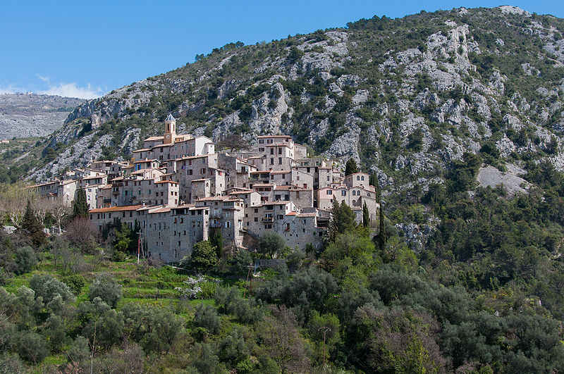
English: A view across the Paillon Valley of the town of Peillon, France.
Peillon is a picturesque fortified village about 15 miles north of Nice, France. The village is perched on top of a high narrow rocky peak, with the compact collection of stone houses, narrow streets, vaulted passages, and sometimes steep stairs. The area has been inhabited since the Iron Age age and the first fortifed town was built on the site near the end of the 10th Century. Most of the current buildings date from the 19th Century, but a few date from the 17th Century. Peillon sits on top of a narrow peak about three miles from the Peillon-Saint Thecle SNCF train station (which houses a small railroad museum open during the summer months). The uphill walk to the town take a little over an hour following the road to town or a hiking path through the countryside. Unlike many other medieval towns in the area, Peillon is an authentic town which is not oriented towards tourists. There are not souvenir shops or other tourist-oriented facilities. The only amenities are one restaurant inside the town and two more in the auberges just outside the town. |
| Date | |
| Source | https://www.flickr.com/photos/fischerfotos/8722255804/ |
| Auteur | Mark Fischer |
| Lieu de la prise de vue | | Voir cet endroit et d’autres images sur : OpenStreetMap |
|---|
Conditions d’utilisation
| Cette image a été publiée sur Flickr. Sa licence a été vérifiée comme "cc-by-sa-2.0" par l'extension UploadWizard au moment où elle a été transférée sur Wikimedia Commons. Voir les informations de licence pour plus de détails. |
- Vous êtes libre :
- de partager – de copier, distribuer et transmettre cette œuvre
- d’adapter – de modifier cette œuvre
- Sous les conditions suivantes :
- paternité – Vous devez donner les informations appropriées concernant l'auteur, fournir un lien vers la licence et indiquer si des modifications ont été faites. Vous pouvez faire cela par tout moyen raisonnable, mais en aucune façon suggérant que l’auteur vous soutient ou approuve l’utilisation que vous en faites.
- partage à l’identique – Si vous modifiez, transformez, ou vous basez sur cette œuvre, vous devez distribuer votre contribution sous la même licence ou une licence compatible avec celle de l’original.
Historique du fichier
Cliquer sur une date et heure pour voir le fichier tel qu'il était à ce moment-là.
| Date et heure | Vignette | Dimensions | Utilisateur | Commentaire | |
|---|---|---|---|---|---|
| actuel | 10 août 2015 à 01:53 | | 3 565 × 2 368 (3,22 Mio) | Alifazal | User created page with UploadWizard |
Utilisation du fichier
Les 2 pages suivantes utilisent ce fichier :
Usage global du fichier
Les autres wikis suivants utilisent ce fichier :