
Fichier:Orkney Map.png
Taille de cet aperçu : 506 × 600 pixels. Autres résolutions : 202 × 240 pixels | 405 × 480 pixels | 788 × 934 pixels.
Fichier d’origine (788 × 934 pixels, taille du fichier : 162 kio, type MIME : image/png)
Ce fichier et sa description proviennent de Wikimedia Commons.
Description
| Description |
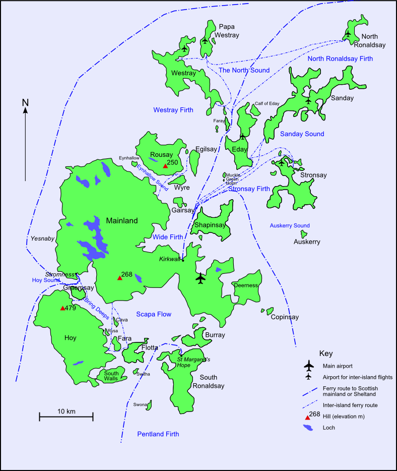
English: Map of Orkney with main transport links - based on many other maps |
| Date | |
| Source | Travail personnel |
| Auteur | Mikenorton |
Conditions d’utilisation
Moi, en tant que détenteur des droits d’auteur sur cette œuvre, je la publie sous les licences suivantes :
Ce fichier est disponible selon les termes de la licence Creative Commons Attribution – Partage dans les Mêmes Conditions 3.0 (non transposée).
- Vous êtes libre :
- de partager – de copier, distribuer et transmettre cette œuvre
- d’adapter – de modifier cette œuvre
- Sous les conditions suivantes :
- paternité – Vous devez donner les informations appropriées concernant l'auteur, fournir un lien vers la licence et indiquer si des modifications ont été faites. Vous pouvez faire cela par tout moyen raisonnable, mais en aucune façon suggérant que l’auteur vous soutient ou approuve l’utilisation que vous en faites.
- partage à l’identique – Si vous modifiez, transformez, ou vous basez sur cette œuvre, vous devez distribuer votre contribution sous la même licence ou une licence compatible avec celle de l’original.

|
Vous avez la permission de copier, distribuer et modifier ce document selon les termes de la GNU Free Documentation License version 1.2 ou toute version ultérieure publiée par la Free Software Foundation, sans sections inaltérables, sans texte de première page de couverture et sans texte de dernière page de couverture. Un exemplaire de la licence est inclus dans la section intitulée GNU Free Documentation License. |
Vous pouvez choisir l’une de ces licences.
Historique du fichier
Cliquer sur une date et heure pour voir le fichier tel qu'il était à ce moment-là.
| Date et heure | Vignette | Dimensions | Utilisateur | Commentaire | |
|---|---|---|---|---|---|
| actuel | 12 mai 2018 à 08:52 | | 788 × 934 (162 kio) | RokerHRO | clipped unnecessary semi-transparent pixel rows at the top. optipng -o7 -zm1-9 -> reduction by 28% |
| 27 avril 2012 à 22:40 |  | 788 × 937 (226 kio) | Mikenorton | Corrected labels for Wyre and Egilsay, which were swapped | |
| 23 septembre 2009 à 15:43 |  | 788 × 937 (226 kio) | Mikenorton | {{Information |Description={{en|1=Map of Orkney with main transport links - based on many other maps}} |Source=Own work by uploader |Author=Mikenorton |Date=2009-09-23 |Permission= |other_versions= }} |
Utilisation du fichier
La page suivante utilise ce fichier :
Usage global du fichier
Les autres wikis suivants utilisent ce fichier :
- Utilisation sur en.wikipedia.org
- Utilisation sur gl.wikipedia.org
- Utilisation sur it.wikipedia.org
- Utilisation sur nl.wikipedia.org
- Utilisation sur sl.wikipedia.org
- Utilisation sur war.wikipedia.org