
Fichier:Kingdom of the Isles, circa 1200 (png version).png
Pas de plus haute résolution disponible.
Kingdom_of_the_Isles,_circa_1200_(png_version).png (384 × 528 pixels, taille du fichier : 104 kio, type MIME : image/png)
Ce fichier et sa description proviennent de Wikimedia Commons.
.png?uselang=fr)
Description
| Description |
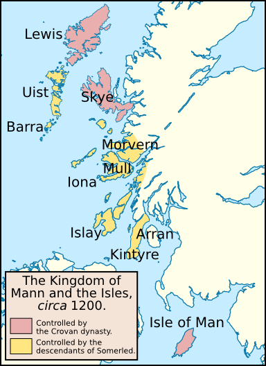
English: Map of the Kingdom of the Isles, circa 1200. I created this map using Inkscape. I used the following image to create this map: File:United_Kingdom_location_map.svg. I based this map off one published in: McDonald, R.A. (2007). Manx Kingship in its Irish sea Setting, 1187–1229: King Rǫgnvaldr and the Crovan dynasty. Four Courts Press. 978-1-84682-047-2. |
| Date | |
| Source | Travail personnel |
| Auteur | Brianann MacAmhlaidh |
| Autres versions | File:Kingdom of the Isles, circa 1200.svg (SVG version). |
Conditions d’utilisation
Moi, en tant que détenteur des droits d’auteur sur cette œuvre, je la publie sous la licence suivante :
Ce fichier est disponible selon les termes de la licence Creative Commons Attribution – Partage dans les Mêmes Conditions 3.0 (non transposée).
- Vous êtes libre :
- de partager – de copier, distribuer et transmettre cette œuvre
- d’adapter – de modifier cette œuvre
- Sous les conditions suivantes :
- paternité – Vous devez donner les informations appropriées concernant l'auteur, fournir un lien vers la licence et indiquer si des modifications ont été faites. Vous pouvez faire cela par tout moyen raisonnable, mais en aucune façon suggérant que l’auteur vous soutient ou approuve l’utilisation que vous en faites.
- partage à l’identique – Si vous modifiez, transformez, ou vous basez sur cette œuvre, vous devez distribuer votre contribution sous la même licence ou une licence compatible avec celle de l’original.
Historique du fichier
Cliquer sur une date et heure pour voir le fichier tel qu'il était à ce moment-là.
| Date et heure | Vignette | Dimensions | Utilisateur | Commentaire | |
|---|---|---|---|---|---|
| actuel | 28 mai 2011 à 08:20 | | 384 × 528 (104 kio) | Brianann MacAmhlaidh | fixed the colour of a few islands |
| 27 mai 2011 à 09:44 |  | 384 × 528 (104 kio) | Brianann MacAmhlaidh |
Utilisation du fichier
La page suivante utilise ce fichier :
Usage global du fichier
Les autres wikis suivants utilisent ce fichier :
- Utilisation sur ar.wikipedia.org
- Utilisation sur az.wikipedia.org
- Utilisation sur bn.wikipedia.org
- Utilisation sur de.wikipedia.org
- Utilisation sur en.wikipedia.org
- Utilisation sur it.wikipedia.org
- Utilisation sur kk.wikipedia.org
- Utilisation sur sl.wikipedia.org
.png)