
Fichier:Homann Amplissimae Regionis Mississipi c. 1720 UTA.jpg

Taille de cet aperçu : 676 × 599 pixels. Autres résolutions : 271 × 240 pixels | 541 × 480 pixels | 866 × 768 pixels | 1 155 × 1 024 pixels | 2 309 × 2 048 pixels | 6 000 × 5 321 pixels.
Fichier d’origine (6 000 × 5 321 pixels, taille du fichier : 16,4 Mio, type MIME : image/jpeg)
Ce fichier et sa description proviennent de Wikimedia Commons.
Description
| Titre |
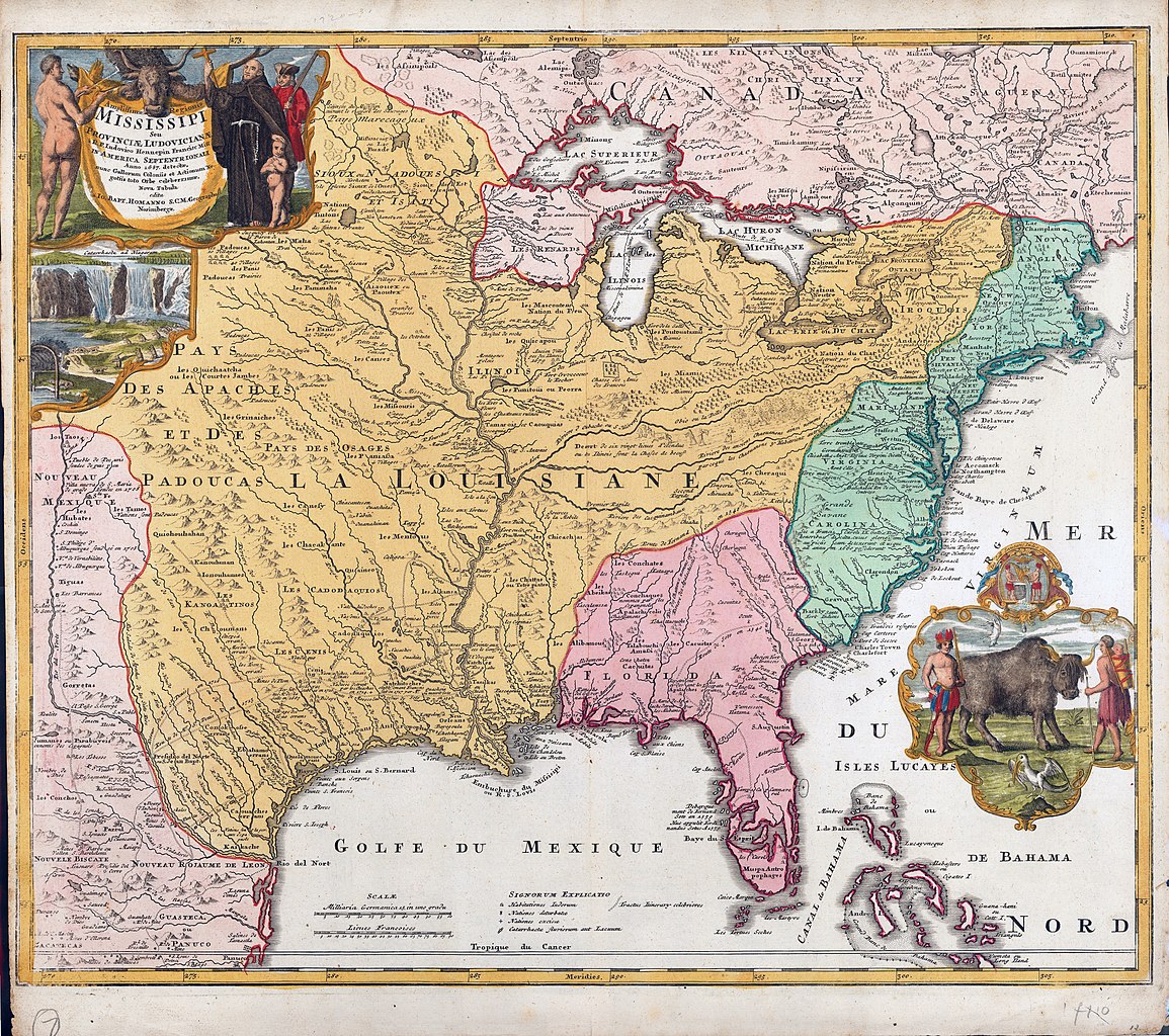
Latina: Amplißimae Regionis Mississippi seu Provinciae Ludovicianae a R. P. Ludovico Hennepin Francisc Miss in America Septentrionali anno 1687 detecte |
||||||||||||||||||||||||||
| Description |
English: In the early eighteenth century, Nuremberg cartographer, map publisher, and engraver Johann Baptist Homann paid homage to French Catholic missionary friar, explorer, and cartographer Father Louis Hennepin with this map of Louisiana and the Mississippi Valley. The cartouche at top left, which credits Hennepin with the discovery of the province of Louisiana, includes an imaginary likeness of the Franciscan Recollect missionary in his brown cloak and robe. The Franciscans wore a rope belt tied at the waist and knotted three times to symbolize the order's three vocational rules of poverty, obedience, and chastity. Here Hennepin holds up a cross and places his hand upon a young child, who, like the man on the left side of the cartouche, is completely naked. Homann intended these nudes to represent Native Americans although their physical features are entirely European – a common depiction at this time for European artists who had probably never seen a Native American firsthand. The Indian man offers a peace pipe in one hand. Accompanying Hennepin at right is a French soldier wearing a three-cornered hat and carrying a musket. A bison head decorates the top of the cartouche. Below this image is a vignette copy of a widely popular landscape print of Niagara Falls, included as a reference to Hennepin as the first European to describe the natural wonder. Homann probably felt some affinity for Hennepin despite the fact that the German reportedly converted to the Evangelical or Lutheran faith in 1687. As a young man, Homann had originally embarked upon a Catholic monastic education under the Dominican order. |
||||||||||||||||||||||||||
| Date | vers 1720 | ||||||||||||||||||||||||||
| Source | UTA Libraries Cartographic Connections: carte / texte | ||||||||||||||||||||||||||
| Créé par |
|
||||||||||||||||||||||||||
| Attribution de l’acquisition |
English: UTA Libraries Special Collections, Gift of Virginia Garrett |
||||||||||||||||||||||||||
| Géoréférencement | Si c'est inapproprié, définissez warp_status = skip pour masquer. | ||||||||||||||||||||||||||
| Données bibliographiques | |||||||||||||||||||||||||||
| Lieu de publication | Nuremberg | ||||||||||||||||||||||||||
| Imprimé par |
|
||||||||||||||||||||||||||
| Données d'archives | |||||||||||||||||||||||||||
| Collection |
|
||||||||||||||||||||||||||
| Dimensions | hauteur : 47 cm ; largeur : 57 cm | ||||||||||||||||||||||||||
| Technique / matériaux | gravure colorée | ||||||||||||||||||||||||||
| artwork-references | Sandler, Christian (1979) Johann Baptista Homann, die Homännischen Erben, Matthäus Seutter und Ihre Landkarten: Beiträge zur Geschichte der Kartographie, Amsterdam : Meridian Publishing Co., pp. 42−43 | ||||||||||||||||||||||||||
.jpg)
Conditions d’utilisation

|
This file was provided to Wikimedia Commons by the University of Texas at Arlington Libraries as part of a cooperation project. The University of Texas at Arlington Libraries is part of the University of Texas at Arlington, a public research university located in Arlington, Texas.
|
|
L’auteur est mort en 1724 ; cette œuvre est donc également dans le domaine public dans tous les pays pour lesquels le droit d’auteur a une durée de vie de 100 ans ou moins après la mort de l’auteur. Cette œuvre est dans le domaine public aux États-Unis car elle a été publiée avant le 1er janvier 1929. | |
| Ce fichier a été identifié comme étant exempt de restrictions connues liées au droit d’auteur, y compris tous les droits connexes et voisins. | |
Historique du fichier
Cliquer sur une date et heure pour voir le fichier tel qu'il était à ce moment-là.
| Date et heure | Vignette | Dimensions | Utilisateur | Commentaire | |
|---|---|---|---|---|---|
| actuel | 15 février 2022 à 19:49 | | 6 000 × 5 321 (16,4 Mio) | Michael Barera | == {{int:filedesc}} == {{Map |title = {{la|'''''Amplißimae Regionis Mississippi seu Provinciae Ludovicianae a R. P. Ludovico Hennepin Francisc Miss in America Septentrionali anno 1687 detecte'''''}} |description = {{en|In the early eighteenth century, Nuremberg cartographer, map publisher, and engraver Johann Baptist Homann paid homage to French Catholic missionary friar, explorer, and cartographer Father Louis Hennepin with this map of Louisiana and the Mississippi Valley... |
Utilisation du fichier
La page suivante utilise ce fichier :
Usage global du fichier
Les autres wikis suivants utilisent ce fichier :
- Utilisation sur de.wikipedia.org
- Utilisation sur en.wikipedia.org
- Utilisation sur es.wikipedia.org
- Utilisation sur id.wikipedia.org
- Utilisation sur nl.wikipedia.org
- Utilisation sur pt.wikipedia.org