
Fichier:Captaincy General of Chile (orthographic projection).svg

Taille de cet aperçu PNG pour ce fichier SVG : 550 × 550 pixels. Autres résolutions : 240 × 240 pixels | 480 × 480 pixels | 768 × 768 pixels | 1 024 × 1 024 pixels | 2 048 × 2 048 pixels.
Fichier d’origine (Fichier SVG, nominalement de 550 × 550 pixels, taille : 844 kio)
Ce fichier et sa description proviennent de Wikimedia Commons.
Description
| Description |
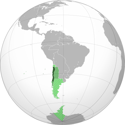
English: Approximate extension of the Captaincy General of Chile in orthographic projection.
Territory under efective control of the Captaincy by 1786. Territory of the Captaincy, ceded or transfered before 1786. Claimed, disputed, not under effective control or only nominal control territory asociated to the Captaincy by 1786. Claimed, disputed, not under effective control or only nominal control territory associated with ceded territories of the Captaincy. Español: Ubicación geográfica aproximada de la Capitanía General de Chile en proyección ortográfica.
Territorio efectivo de la Capitanía hacia 1786. Territorio de la Capitanía, cedido o transferido a otras entidades previo a 1786. Territorio reclamado, disputado, sin control efectivo o sólo control nominal asociado a la Capitanía hacia 1786. Territorio reclamado, disputado, sin control efectivo o sólo control nominal asociado a territorios cedidos por la Capitanía. |
||
| Date | |||
| Source |
Travail personnel basé sur : the Brazil (orthographic projection).svg, created by the Wikimedia Commons user Ssolbergj, under a Creative Commons Licence. Boundaries based in the following sources:
|
||
| Auteur | B1mbo | ||
| Autorisation (Réutilisation de ce fichier) |
Moi, en tant que détenteur des droits d’auteur sur cette œuvre, je la publie sous la licence suivante : Ce fichier est disponible selon les termes de la licence Creative Commons Attribution 3.0 Non transposée.
|
||
| Autres versions |
.svg)
|
||
| SVG information |
.svg)
.svg)
.svg)
.svg)
.svg)
.svg)
.svg)
.svg)
.svg)
.svg)
.svg)
.svg)
.svg)
.svg)
.svg)
.svg)
.svg)
.svg)
.svg)
.svg)
.svg)
.svg)
.svg)
.svg)
.svg)
.svg)
.svg)
.svg)
.svg)
.svg)
.svg)
.svg)
.svg)
.svg)
.svg)
.svg)
.svg)
.svg)
.svg)
.svg)
.svg)
.svg)
.svg)
.svg)
.svg)
.svg)
.svg)
.svg)
.svg)
.svg)
.svg)
.svg)
.svg)
.svg)
.svg)
.svg)
.svg)
.svg)
.svg)
.svg)
.svg)
.svg)
.svg)
.svg)
.svg)
.svg)
.svg)
.svg)
.svg)
.svg)
.svg)
.svg)
.svg)

.svg)

.svg)

.svg)
.svg)
.svg)
.svg)
.svg)
.svg)
.svg)


.svg)
.svg)
.svg)
.svg)
.svg)
.svg)
.svg)

.svg)
.svg)
.svg)
.svg)
.svg)
.svg)
.svg)
.svg)
.svg)

.svg)
.svg)
.svg)
.svg)
.svg)
.svg)
.svg)
_without_national_boundaries.svg)
.svg)
.svg)
.svg)
.svg)
.svg)
.svg)

.svg)
.svg)
.png)
.svg)
.svg)
.svg)
.svg)

.svg)
.svg)
.svg)
.svg)
.svg)
.svg)
.svg)
.svg)
.svg)
.svg)
.svg)

.svg)
.svg)
.svg)
.svg)
.svg)
.svg)
.svg)
.svg)
.svg)

.svg)
.svg)

.svg)
.svg)
.svg)
.svg)
.svg)
.svg)
.svg)
.svg)
.svg)
.svg)
.svg)
.svg)
.svg)
.svg)
.svg)
.svg)
.svg)
.svg)
.svg)
.svg)
.svg)
.svg)
.svg)
.svg)
.svg)
.svg)
.svg)
_-_Crimea_disputed.svg)
.svg)
.svg)
.svg)
.svg)
.svg)
.svg)
.svg)
.svg)
.svg)
.svg)
.svg)
_political.svg)
.svg)
.svg)
.svg)
.svg)
_-_Crimea_disputed_-_no_borders.svg)
.svg)
.svg)
.svg)
.svg)
.svg)
.svg)
.svg)
.svg)
.svg)
.svg)
.svg)

.svg)
.svg)
.svg)

.png)
.svg)
.svg)
.svg)
.svg)
.svg)
.svg)
.svg)
.svg)
.svg)
.svg)
.svg)
.svg)
.svg)
.svg)
.svg)
.svg)
.svg)
.svg)
.svg)
.svg)
.svg)
.svg)
.svg)
.svg)
.svg)
.svg)
.svg)
.svg)
.svg)
.svg)
.svg)
.svg)
.svg)
.svg)
.png)
.svg)
.svg)
.svg)
_(orthographic_projection).png)

.svg?uselang=fr)
.svg)
.jpg)
.svg)
Historique du fichier
Cliquer sur une date et heure pour voir le fichier tel qu'il était à ce moment-là.
| Date et heure | Vignette | Dimensions | Utilisateur | Commentaire | |
|---|---|---|---|---|---|
| actuel | 7 novembre 2022 à 21:36 | | 550 × 550 (844 kio) | Janitoalevic | Borders bases on the Map of Cano y Olmedilla of 1775 |
| 18 octobre 2022 à 18:54 |  | 550 × 550 (373 kio) | Janitoalevic | Added Terra Australis (1555) and Easter Island (1770) | |
| 8 juillet 2022 à 00:37 |  | 550 × 550 (364 kio) | Janitoalevic | límite en el río Loa entre la prov. de Santiago y Arequipa (Eyzaguirre, Jaime, 1967) | |
| 20 septembre 2019 à 00:11 |  | 550 × 550 (253 kio) | B1mbo | Correcciones | |
| 10 juillet 2012 à 19:00 |  | 550 × 550 (139 kio) | Jespinos | Reverted to version as of 16:58, 10 July 2012 | |
| 10 juillet 2012 à 18:58 |  | 550 × 550 (150 kio) | Jespinos | Reverted to version as of 09:07, 26 May 2012 | |
| 10 juillet 2012 à 18:58 |  | 550 × 550 (139 kio) | Jespinos | Reverted to version as of 23:27, 20 June 2010 | |
| 26 mai 2012 à 11:07 |  | 550 × 550 (150 kio) | Franco-eisenhower | Límite verdadero Patagonia: http://www.scielo.cl/scielo.php?pid=S0717-71942002003500009&script=sci_arttext&tlng=es | |
| 21 juin 2010 à 01:27 |  | 550 × 550 (139 kio) | B1mbo | == Summary == {{created with Inkscape}} {{Information |Description= {{en|Location of the Captaincy General of Chile in orthographic projection, approx. 1796. {{legend|DarkGreen|Sovereign territory.}} {{legend|Lime|Terr |
Utilisation du fichier
La page suivante utilise ce fichier :
Usage global du fichier
Les autres wikis suivants utilisent ce fichier :
- Utilisation sur ar.wikipedia.org
- Utilisation sur ca.wikipedia.org
- Utilisation sur cs.wikipedia.org
- Utilisation sur en.wikipedia.org
- Utilisation sur es.wikipedia.org
- Utilisation sur eu.wikipedia.org
- Utilisation sur he.wikipedia.org
- Utilisation sur it.wikipedia.org
- Utilisation sur lt.wikipedia.org
- Utilisation sur pt.wikipedia.org
- Utilisation sur ru.wikipedia.org
- Utilisation sur sv.wikipedia.org
- Utilisation sur th.wikipedia.org
- Utilisation sur uk.wikipedia.org
- Utilisation sur www.wikidata.org
- Utilisation sur zh.wikipedia.org
.svg)