Aller au contenu

Fichier:Boyle crater clementine color albedo.jpg

Le contenu de la page n’est pas pris en charge dans d’autres langues.
Une page de Wikipédia, l'encyclopédie libre.

Fichier d’origine(1 136 × 1 023 pixels, taille du fichier : 681 kio, type MIME : image/jpeg)

Ce fichier et sa description proviennent de Wikimedia Commons.

Description

Description
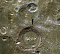
English: Boyle crater in the southern region of the far side of the Moon. Satellite craters A and Z to the north also marked. Cropped and annotated version (by uploader) of computer generated image by PDS MAP-A-PLANET.
Date Date inconnue
Unknown date
/combined
Source http://pdsmaps.wr.usgs.gov/explorer-bin/mapmars4.cgi?WHEREFROM=DOUBLE&DLINE=4096&DSAMP=2200&VERSION=ADVANCED&DATA_SET_NAME=moon_clementine_multi&PIXEL_TYPE=BIT8&SCALE=pixels/degree&PROJECTION=SINUSOIDAL&RESOLUTION=256&RESAMP_METHOD=NEAREST_NEIGHBOR&BANDS_SELECTED=&FORMAT=JPEG&LONBOX=14.52&LATBOX=16&GRIDLINE_FREQUENCY=none&STRETCH=AUTO&LAT=-57.700000&LON=175.2&LINE=2048&SAMP=1100
Auteur NASA space probe Clementine (USGS PDS MAP-A-PLANET)

Conditions d’utilisation

Public domain
Cette image est placée dans le domaine public parce qu'elle contient des éléments issus de l'United States Geological Survey, une agence du Département de l'Intérieur des États-Unis. Pour plus d'information, consultez la politique officielle de copyright de l'USGS (en anglais)

Bahasa Indonesia  català  čeština  Deutsch  eesti  English  español  français  galego  italiano  Nederlands  português  polski  sicilianu  suomi  Tiếng Việt  Türkçe  български  македонски  русский  മലയാളം  한국어  日本語  中文  中文(简体)  中文(繁體)  العربية  فارسی  +/−

Légendes

Ajoutez en une ligne la description de ce que représente ce fichier

Éléments décrits dans ce fichier

dépeint

image/jpeg

58d86e93a1111662ea27ac0353b209404f36003d

697 478 octet

1 023 pixel

1 136 pixel

Historique du fichier

Cliquer sur une date et heure pour voir le fichier tel qu'il était à ce moment-là.

Date et heureVignetteDimensionsUtilisateurCommentaire
actuel31 mars 2009 à 14:06Vignette pour la version du 31 mars 2009 à 14:061 136 × 1 023 (681 kio)Njaelkies LeaSatellite crater annotation moved by convention
31 mars 2009 à 13:49Vignette pour la version du 31 mars 2009 à 13:491 136 × 1 023 (681 kio)Njaelkies Lea{{Information |Description={{en|1=Boyle crater in the southern region of the far side of the Moon. Satellite craters A and Z to the north also marked. Cropped and annotated version (by uploader) of computer generated image by PDS MA

La page suivante utilise ce fichier :

Usage global du fichier

Les autres wikis suivants utilisent ce fichier :

Métadonnées