
Fichier:Virgin Forest in United States, 1926.png
Taille de cet aperçu : 800 × 497 pixels. Autres résolutions : 320 × 199 pixels | 640 × 398 pixels | 1 024 × 637 pixels | 1 280 × 796 pixels | 2 560 × 1 591 pixels | 4 200 × 2 611 pixels.
Fichier d’origine (4 200 × 2 611 pixels, taille du fichier : 3,57 Mio, type MIME : image/png)
Ce fichier et sa description proviennent de Wikimedia Commons.
Description
| Description |
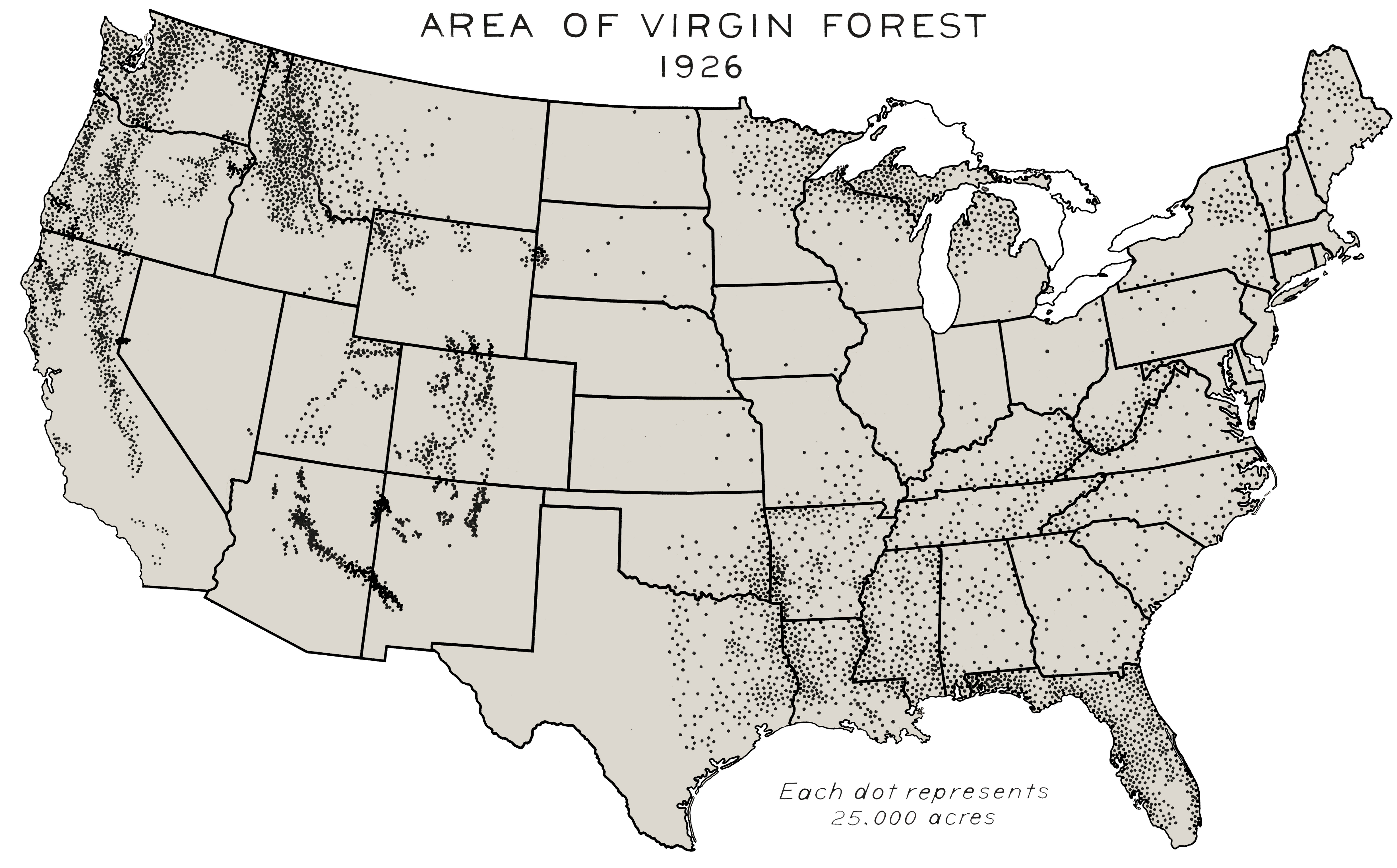
English: Forests never harvested by European settlers or their descendants, 1926. This map of the area of virgin forest in 1926 was compiled by William B. Greeley, who was chief of the U.S. Forest Service from 1920 to 1928, in his 1925 book The Relation of Geography to Timber Supply. This high-resolution version was created by the World Resources Institute from the original map in the U.S. National Archives.[1] This map can be seen as part of a four-image set constituted of File:Virgin Forest in United States, 1620.png, File:Virgin Forest in United States, 1850.png and a last one with protected copy rights[2] |
| Date | |
| Source | Southern Forests Flickr |
| Auteur | William B. Greeley, US Forest Service |
Conditions d’utilisation
This image is a work of the Forest Service of the United States Department of Agriculture. As a work of the U.S. federal government, the image is in the public domain.
|
- ↑ see caption of the original image on Flickr.
- ↑ George Draffan (1992). Virgin Forests Today. Flickr. Southern Forests.
Historique du fichier
Cliquer sur une date et heure pour voir le fichier tel qu'il était à ce moment-là.
| Date et heure | Vignette | Dimensions | Utilisateur | Commentaire | |
|---|---|---|---|---|---|
| actuel | 29 avril 2012 à 21:55 | | 4 200 × 2 611 (3,57 Mio) | Hotshot977 |
Utilisation du fichier
Les 2 pages suivantes utilisent ce fichier :
Usage global du fichier
Les autres wikis suivants utilisent ce fichier :