
Fichier:Tram map of Bochum and Gelsenkirchen.xcf

Fichier d’origine (1 110 × 1 050 pixels, taille du fichier : 2,9 Mio, type MIME : image/x-xcf)
Ce fichier et sa description proviennent de Wikimedia Commons.
|
Cette XCF image matricielle a été créée avec GIMP.
|
Description
| Description |
English: Tramway network of Bochum and Gelsenkirchen, Germany Deutsch: Topographischer Netzplan des Straßenbahnnetzes in Bochum und Gelsenkirchen |
|||
| Date | ||||
| Source | openstreetmap.org | |||
| Créé par |
contributeurs d'OpenStreetMap |
|||
| Autorisation (Réutilisation de ce fichier) |
Les données d'OpenStreetMap sont disponibles sous la license Open Database (détails). Les cartes sont publiées sous license Creative Commons Attribution-Partage dans les Mêmes Conditions 2.0 (CC-BY-SA 2.0).
Ce fichier est disponible selon les termes de la licence Creative Commons Attribution – Partage dans les Mêmes Conditions 2.0 Générique
|
|||
| Géoréférencement | Si c'est inapproprié, définissez warp_status = skip pour masquer. |
Historique du fichier
Cliquer sur une date et heure pour voir le fichier tel qu'il était à ce moment-là.
| Date et heure | Vignette | Dimensions | Utilisateur | Commentaire | |
|---|---|---|---|---|---|
| actuel | 12 février 2023 à 10:13 |  | 1 110 × 1 050 (2,9 Mio) | Bürgerentscheid | Abzweig O-Werk ergänzt, ab 2023-01-09 |
| 1 novembre 2020 à 18:37 |  | 1 110 × 1 050 (2,88 Mio) | Bürgerentscheid | update 2020-11-01 | |
| 11 janvier 2020 à 19:37 | 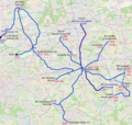 | 1 110 × 1 050 (2,88 Mio) | Bürgerentscheid | Witten: track between Heven Dorf und Papenholz with regular circulation. | |
| 21 décembre 2019 à 19:38 |  | 1 110 × 1 050 (2,88 Mio) | Bürgerentscheid | updated to 2019-12-15 | |
| 14 avril 2013 à 08:32 | 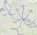 | 1 110 × 1 050 (3,01 Mio) | Bürgerentscheid | {{XCF}} == {{int:filedesc}} == {{Information |Description=Tramway network of Bochum and Gelsenkirchen |Date=2013-04-14 |Author= Bürgerentscheid |Source= Openstreetmap |Permission= |other_versions=[[File:Tram map of Bochum and... |
Utilisation du fichier
La page suivante utilise ce fichier :
Usage global du fichier
Les autres wikis suivants utilisent ce fichier :
- Utilisation sur de.wikipedia.org
- Utilisation sur en.wikipedia.org
- Utilisation sur fa.wikipedia.org
- Utilisation sur it.wikipedia.org
- Utilisation sur ja.wikipedia.org
- Utilisation sur nl.wikipedia.org
- Utilisation sur pt.wikipedia.org
- Utilisation sur ru.wikipedia.org