
Fichier:Southeast Missouri Lead District - subdistricts map.svg

Fichier d’origine (Fichier SVG, nominalement de 868 × 730 pixels, taille : 302 kio)
Ce fichier et sa description proviennent de Wikimedia Commons.
Description
| Description |
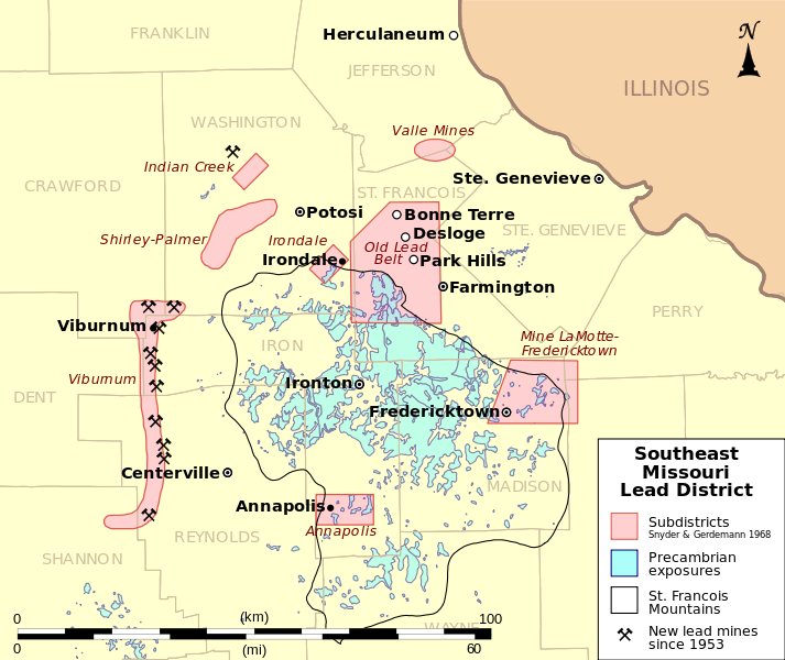
English: This is a map showing subdistricts of the Southeast Missouri Lead District and the locations of mines opened since 1953, some now closed, all on the west side of the district. The Indian Creek Mine opened in 1953 following exploration for new deposits to replace those being depleted in the Old Lead Belt, and development of the Viburnum Trend subdistrict followed. Six mines of the Doe Run Company are active as of 2010 according to the company's website.[1]
Boundaries of the subdistricts were taken from USGS Scientific Investigations Report 2008-5140 which cites Snyder, F.G., and Gerdemann, P.E., 1968, Geology of the Southeast Missouri Lead District, in Ridge, J.D., ed., Ore deposits of the United States, 1933-1967: New York, The American Institute of Mining Metallurgical and Petroleum Engineers, Inc., p. 327-358. Locations of mines taken from Inventory of Mines, Occurrences, and Prospects in Missouri, Missouri Department of Natural Resources (MoDNR), Division of Geology and Land Survey (DGLS), Geological Survey Program (GSP) 2008-01-10. Digital vector data Map projection: UTM Zone 15N |
| Date | |
| Source | Travail personnel |
| Auteur | Kbh3rd |
Conditions d’utilisation
- Vous êtes libre :
- de partager – de copier, distribuer et transmettre cette œuvre
- d’adapter – de modifier cette œuvre
- Sous les conditions suivantes :
- paternité – Vous devez donner les informations appropriées concernant l'auteur, fournir un lien vers la licence et indiquer si des modifications ont été faites. Vous pouvez faire cela par tout moyen raisonnable, mais en aucune façon suggérant que l’auteur vous soutient ou approuve l’utilisation que vous en faites.
- partage à l’identique – Si vous modifiez, transformez, ou vous basez sur cette œuvre, vous devez distribuer votre contribution sous la même licence ou une licence compatible avec celle de l’original.
| Annotations | Cette image est annotée : Voir les annotations sur Wikimedia Commons |
Historique du fichier
Cliquer sur une date et heure pour voir le fichier tel qu'il était à ce moment-là.
| Date et heure | Vignette | Dimensions | Utilisateur | Commentaire | |
|---|---|---|---|---|---|
| actuel | 3 avril 2010 à 19:32 | | 868 × 730 (302 kio) | Kbh3rd | Fix date in key; The Indian Creek mine began producing in 1953, not 1963, according to USGS Scientific Investigations Report 2008-5140. |
| 29 mars 2010 à 05:04 |  | 868 × 730 (302 kio) | Kbh3rd | Fix scale bar. See talk. | |
| 28 mars 2010 à 23:53 |  | 868 × 730 (294 kio) | Kbh3rd | Take another tack to try to fix Commons' text rendering bug | |
| 28 mars 2010 à 22:57 |  | 868 × 730 (326 kio) | Kbh3rd | Another attempt to fix font problem that does not appear in Firefox3, Gimp, or rsvg-view. Wikimedia... Grrr! | |
| 28 mars 2010 à 22:48 |  | 868 × 730 (333 kio) | Kbh3rd | Attempt to fix munged text size introducec by previous change... | |
| 28 mars 2010 à 21:47 |  | 868 × 730 (333 kio) | Kbh3rd | Scale bar; North arrow; Conventional mine symbol | |
| 28 mars 2010 à 08:24 |  | 868 × 730 (271 kio) | Kbh3rd | {{Information |Description={{en|1=Map showing the subdistricts of the Southeast Missouri Lead District and the locations of mines -- open and closed -- which have been active since 1963, all on the west side of the district. The Indian |
Utilisation du fichier
La page suivante utilise ce fichier :
Usage global du fichier
Les autres wikis suivants utilisent ce fichier :
- Utilisation sur en.wikipedia.org