
Fichier:Sayer Accurate Map of North America 1775 UTA (top).jpg
Taille de cet aperçu : 800 × 358 pixels. Autres résolutions : 320 × 143 pixels | 640 × 286 pixels | 1 431 × 640 pixels.
Fichier d’origine (1 431 × 640 pixels, taille du fichier : 804 kio, type MIME : image/jpeg)
Ce fichier et sa description proviennent de Wikimedia Commons.
Description
| Titre |
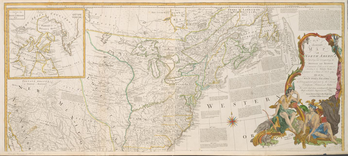
English: An Accurate Map of North America Describing and distinguishing the British and Spanish Dominions of this great Continent According to the Definitive Treaty Concluded at Paris 10th Feby. 1763... |
|||||||||||||||||||||||||||||||||||||||||||||||||
| Date | ||||||||||||||||||||||||||||||||||||||||||||||||||
| Source | UTA Libraries Cartographic Connections: carte / texte | |||||||||||||||||||||||||||||||||||||||||||||||||
| Créé par |
|
|||||||||||||||||||||||||||||||||||||||||||||||||
| Attribution de l’acquisition |
English: UTA Libraries Special Collections, Gift of Virginia Garrett |
|||||||||||||||||||||||||||||||||||||||||||||||||
| Données géotemporelles | ||||||||||||||||||||||||||||||||||||||||||||||||||
| Lieu | Amérique du Nord | |||||||||||||||||||||||||||||||||||||||||||||||||
| Géoréférencement | Si c'est inapproprié, définissez warp_status = skip pour masquer. | |||||||||||||||||||||||||||||||||||||||||||||||||
| Données bibliographiques | ||||||||||||||||||||||||||||||||||||||||||||||||||
| Lieu de publication | Londres | |||||||||||||||||||||||||||||||||||||||||||||||||
| Imprimé par |
|
|||||||||||||||||||||||||||||||||||||||||||||||||
| Données d'archives | ||||||||||||||||||||||||||||||||||||||||||||||||||
| Collection |
|
|||||||||||||||||||||||||||||||||||||||||||||||||
| Dimensions | hauteur : 54 cm ; largeur : 123 cm | |||||||||||||||||||||||||||||||||||||||||||||||||
| Technique / matériaux |
gravure colorée eau-forte colorée |
|||||||||||||||||||||||||||||||||||||||||||||||||
| Autres versions |
|
|||||||||||||||||||||||||||||||||||||||||||||||||
_the_sayer_family_of_richmond_(cropped).jpg)

.jpg)
.jpg?uselang=fr)
Conditions d’utilisation

|
This file was provided to Wikimedia Commons by the University of Texas at Arlington Libraries as part of a cooperation project. The University of Texas at Arlington Libraries is part of the University of Texas at Arlington, a public research university located in Arlington, Texas.
|
|
L’auteur est mort en 1794 ; cette œuvre est donc également dans le domaine public dans tous les pays pour lesquels le droit d’auteur a une durée de vie de 100 ans ou moins après la mort de l’auteur. Cette œuvre est dans le domaine public aux États-Unis car elle a été publiée avant le 1er janvier 1929. | |
| Ce fichier a été identifié comme étant exempt de restrictions connues liées au droit d’auteur, y compris tous les droits connexes et voisins. | |
Historique du fichier
Cliquer sur une date et heure pour voir le fichier tel qu'il était à ce moment-là.
| Date et heure | Vignette | Dimensions | Utilisateur | Commentaire | |
|---|---|---|---|---|---|
| actuel | 18 février 2022 à 17:44 | | 1 431 × 640 (804 kio) | Michael Barera | == {{int:filedesc}} == {{Map |title = {{en|'''''An Accurate Map of North America Describing and distinguishing the British and Spanish Dominions of this great Continent According to the Definitive Treaty Concluded at Paris 10th Feby. 1763...'''''}} |description = |legend = |author = {{Creator:Robert Sayer}} {{after|{{Creator:Emanuel Bowen}}}} {{after|{{Creator:John Gibson}}}} |date = 1775 |source = UTA Libraries ''Cartogr... |
Utilisation du fichier
Aucune page n’utilise ce fichier.
Usage global du fichier
Les autres wikis suivants utilisent ce fichier :
- Utilisation sur de.wikipedia.org
- Utilisation sur en.wikipedia.org
- Utilisation sur id.wikipedia.org
- Utilisation sur it.wikipedia.org
- Utilisation sur ko.wikipedia.org
- Utilisation sur ru.wikipedia.org
.jpg)