
Fichier:SaintPierre1780.png

Taille de cet aperçu : 800 × 464 pixels. Autres résolutions : 320 × 186 pixels | 640 × 371 pixels | 869 × 504 pixels.
Fichier d’origine (869 × 504 pixels, taille du fichier : 828 kio, type MIME : image/png)
Ce fichier et sa description proviennent de Wikimedia Commons.
Description
| Description |
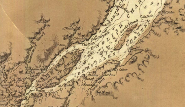
English: This is a detail from the source map, showing locations important in the March 1776 Battle of Saint-Pierre. The source map is captioned as follows: General chart of Gulph and River St. Lawrence |
|||
| Date | ||||
| Source |
URL at time of upload: http://services.banq.qc.ca/sdx/cep/document.xsp?app=ca.BAnQ.sdx.cep&db=notice&id=0002663541&n=13&sortfield=date_publication&col=america&v=saint-laurent_(fleuve)%23%23%23Saint-Laurent+(Fleuve)&order=ascendant&f=lieu_nav&chpp=20&dbrqp=query_notice&qid=sdx_q3 |
|||
| Auteur | Des Barres, Joseph F.W, (Joseph Frederick Wallet), 1722- 1824 |

Conditions d’utilisation
|
Cette œuvre est également dans le domaine public dans tous les pays pour lesquels le droit d’auteur a une durée de vie de 100 ans ou moins après la mort de l’auteur. | |
| Ce fichier a été identifié comme étant exempt de restrictions connues liées au droit d’auteur, y compris tous les droits connexes et voisins. | |
Historique du fichier
Cliquer sur une date et heure pour voir le fichier tel qu'il était à ce moment-là.
| Date et heure | Vignette | Dimensions | Utilisateur | Commentaire | |
|---|---|---|---|---|---|
| actuel | 13 février 2009 à 04:12 | | 869 × 504 (828 kio) | Magicpiano | {{Information |Description={{en|1=This is a detail from the source map, showing locations important in the March 1776 Battle of Saint-Pierre. The source map is captioned as follows: General chart of Gulph and River St. Lawren |
Utilisation du fichier
La page suivante utilise ce fichier :
Usage global du fichier
Les autres wikis suivants utilisent ce fichier :
- Utilisation sur en.wikipedia.org
- Utilisation sur it.wikipedia.org
- Utilisation sur ja.wikipedia.org
- Utilisation sur nl.wikipedia.org
- Utilisation sur www.wikidata.org
- Utilisation sur zh.wikipedia.org