
Fichier:PIA21138 Location of Large Subsurface Water-Ice Deposit in Utopia Planitia, Mars.png

PIA21138_Location_of_Large_Subsurface_Water-Ice_Deposit_in_Utopia_Planitia,_Mars.png (596 × 286 pixels, taille du fichier : 242 kio, type MIME : image/png)
Ce fichier et sa description proviennent de Wikimedia Commons.
Description
| Description |
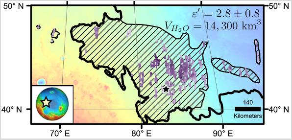
English: Diagonal striping on this map of a portion of the Utopia Planitia region on Mars indicates the area where a large subsurface deposit rich in water ice was assessed using the Shallow Radar (SHARAD) instrument on NASA's Mars Reconnaissance Orbiter.
The area is about halfway between the planet's equator and north pole, and the deposit is estimated to hold about as much water as what is in Lake Superior, largest of the Great Lakes. The scale bar at lower right indicates 140 kilometers (76 miles). The violet vertical bars show depth to the bottom of the ice-rich deposit, as estimated from SHARAD passes overhead. Darkest violet indicates a depth of about 550 feet (about 170 meters). Palest violet indicates a depth of about 33 feet (10 meters). The value of 2.8 plus-or-minus 0.8 in the upper right corner denotes the dielectric constant, a property related to radar reflectivity. The value of 14,300 cubic kilometers is an estimate of the volume of water in the deposit. SHARAD was provided by the Italian Space Agency. Its operations are led by Sapienza University of Rome, and its data are analyzed by a joint U.S.-Italian science team. The Planetary Science Institute, Tucson, Arizona, leads U.S. involvement in SHARAD. NASA's Jet Propulsion Laboratory, a division of Caltech in Pasadena, California, manages the Mars Reconnaissance Orbiter for the NASA Science Mission Directorate, Washington. Lockheed Martin Space Systems, Denver, built the orbiter and supports its operations. |
| Date | (published) |
| Source | Catalog page · Full-res (JPEG · TIFF) |
| Auteur | NASA/JPL-Caltech/Univ. of Rome/ASI/PSI |
Cette image ou vidéo a été cataloguée par le Jet Propulsion Lab de la National Aeronautics and Space Administration (NASA) des États-Unis sous Photo ID : PIA21138.Ce bandeau n’indique rien sur le statut de l’œuvre au regard du droit d'auteur. Un bandeau de droit d’auteur est requis. Voir Commons:À propos des licences pour plus d’informations. Autres langues :
|
 |
This media is a product of the Mars Reconnaissance Orbiter mission Credit and attribution belongs to the Shallow Subsurface Radar (SHARAD) team, NASA/JPL-Caltech/ASI/UT |
Conditions d’utilisation
| Ce fichier provient de la NASA. Sauf exception, les documents créés par la NASA ne sont pas soumis à copyright. Pour plus d'informations, voir la politique de copyright de la NASA. | ||
 |
Attention :
|
Historique du fichier
Cliquer sur une date et heure pour voir le fichier tel qu'il était à ce moment-là.
| Date et heure | Vignette | Dimensions | Utilisateur | Commentaire | |
|---|---|---|---|---|---|
| actuel | 24 novembre 2016 à 19:57 | | 596 × 286 (242 kio) | Drbogdan | User created page with UploadWizard |
Utilisation du fichier
La page suivante utilise ce fichier :
Usage global du fichier
Les autres wikis suivants utilisent ce fichier :
- Utilisation sur bn.wikipedia.org
- Utilisation sur ca.wikipedia.org
- Utilisation sur el.wikipedia.org
- Utilisation sur en.wikipedia.org
- Utilisation sur es.wikipedia.org
- Utilisation sur ja.wikipedia.org
- Utilisation sur ru.wikipedia.org
- Utilisation sur zh.wikipedia.org