
Fichier:Map of the Rancho San Pedro finally confirmed to Manuel Dominguez et al., December 1859 (sc hwmc000790001).jpg

Taille de cet aperçu : 800 × 456 pixels. Autres résolutions : 320 × 182 pixels | 640 × 365 pixels | 1 024 × 584 pixels | 1 280 × 730 pixels | 2 560 × 1 459 pixels | 5 648 × 3 220 pixels.
Fichier d’origine (5 648 × 3 220 pixels, taille du fichier : 2,42 Mio, type MIME : image/jpeg)
Ce fichier et sa description proviennent de Wikimedia Commons.
.jpg?uselang=fr)
Description
| Description |
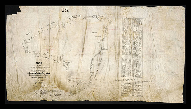
English: Map of the Rancho San Pedro finally confirmed to Manuel Dominguez et al., December 1859
|
| Date | |
| Source | http://digitalcollections.lmu.edu/cdm/ref/collection/hwmaps/id/165 |
| Auteur | Hancock, Henry, 1822-1883 |
Conditions d’utilisation
|
L’auteur est mort en 1883 ; cette œuvre est donc également dans le domaine public dans tous les pays pour lesquels le droit d’auteur a une durée de vie de 100 ans ou moins après la mort de l’auteur. Cette œuvre est dans le domaine public aux États-Unis car elle a été publiée avant le 1er janvier 1929. | |
| Ce fichier a été identifié comme étant exempt de restrictions connues liées au droit d’auteur, y compris tous les droits connexes et voisins. | |
Historique du fichier
Cliquer sur une date et heure pour voir le fichier tel qu'il était à ce moment-là.
| Date et heure | Vignette | Dimensions | Utilisateur | Commentaire | |
|---|---|---|---|---|---|
| actuel | 1 juillet 2014 à 02:39 | | 5 648 × 3 220 (2,42 Mio) | Junkyardsparkle | {{Information |Description={{en|Map of the Rancho San Pedro finally confirmed to Manuel Dominguez et al., December 1859'' :Hand drawn map on linen by deputy surveyor Henry Hancock showing the course of San Gabriel River from Pacific Ocean and Inner Bay... |
Utilisation du fichier
La page suivante utilise ce fichier :
Usage global du fichier
Les autres wikis suivants utilisent ce fichier :
- Utilisation sur en.wikipedia.org
.jpg)