
Fichier:Lockheed 8 Sirius 'Tingmissartoq' at the National Air and Space Museum, Washington DC.jpg

Fichier d’origine (1 600 × 1 066 pixels, taille du fichier : 503 kio, type MIME : image/jpeg)
Ce fichier et sa description proviennent de Wikimedia Commons.
| Description |
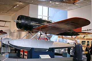
Every possible space in the aircraft was utilized, including the wings and floats, which contained the gasoline tanks. There was plenty of emergency equipment in case the Lindberghs had to make a forced landing in the frozen wilderness. From New York, the Lindberghs flew up the eastern border of Canada to Hopedale, Labrador. From Hopedale they made the first major overwater hop, 650 miles to Godthaab, Greenland, where the Sirius acquired its name—Tingmissartoq, which in Eskimo means "one who flies like a big bird." After crisscrossing Greenland to Baffin Island and back, and then on to Iceland, the Lindberghs proceeded to the major cities of Europe and as far east as Moscow, down the west coast of Africa, and across the South Atlantic to South America. where they flew down the Amazon, and then north through Trinidad and Barbados and back to the United States. They returned to New York on December 19, having traveled 30,000 miles to four continents and twenty-one countries. The information gained from the trip proved invaluable in planning commercial air transport routes for the North and South Atlantic. The aircraft was in the American Museum of Natural History in New York City until 1955. The AirForce Museum in Dayton, Ohio, then acquired it and transferred it to the Smithsonian in 1959. collections.nasm.si.edu/code/emuseum.asp?profile=objects&... |
| Date | |
| Source | Lockheed 8 Sirius "Tingmissartoq" |
| Auteur | Cliff from I now live in Arlington, VA (Outside Washington DC), USA |
| Lieu de la prise de vue | | Voir cet endroit et d’autres images sur : OpenStreetMap |
|---|
Conditions d’utilisation
- Vous êtes libre :
- de partager – de copier, distribuer et transmettre cette œuvre
- d’adapter – de modifier cette œuvre
- Sous les conditions suivantes :
- paternité – Vous devez donner les informations appropriées concernant l'auteur, fournir un lien vers la licence et indiquer si des modifications ont été faites. Vous pouvez faire cela par tout moyen raisonnable, mais en aucune façon suggérant que l’auteur vous soutient ou approuve l’utilisation que vous en faites.
| Cette image a été originellement postée sur Flickr par cliff1066™ à l'adresse https://www.flickr.com/photos/28567825@N03/3344241041. Elle a été passée en revue le 15 novembre 2009 par le robot FlickreviewR, qui a confirmé qu'elle se trouvait sous licence cc-by-2.0. |
Historique du fichier
Cliquer sur une date et heure pour voir le fichier tel qu'il était à ce moment-là.
| Date et heure | Vignette | Dimensions | Utilisateur | Commentaire | |
|---|---|---|---|---|---|
| actuel | 15 novembre 2009 à 20:01 | | 1 600 × 1 066 (503 kio) | Geo Swan | {{Information |Description=Every possible space in the aircraft was utilized, including the wings and floats, which contained the gasoline tanks. There was plenty of emergency equipment in case the Lindberghs had to make a forced landing in the frozen wil |
Utilisation du fichier
Les 2 pages suivantes utilisent ce fichier :
Usage global du fichier
Les autres wikis suivants utilisent ce fichier :
- Utilisation sur ar.wikipedia.org
- Utilisation sur ast.wikipedia.org
- Utilisation sur ca.wikipedia.org
- Utilisation sur en.wikipedia.org
- Utilisation sur es.wikipedia.org
- Utilisation sur fa.wikipedia.org
- Utilisation sur gl.wikipedia.org
- Utilisation sur id.wikipedia.org
- Utilisation sur ja.wikipedia.org
- Utilisation sur no.wikipedia.org
- Utilisation sur pt.wikipedia.org
- Utilisation sur vi.wikipedia.org
- Utilisation sur www.wikidata.org