
Fichier:Geomap Germany.png

Fichier d’origine (2 495 × 4 577 pixels, taille du fichier : 618 kio, type MIME : image/png)
Ce fichier et sa description proviennent de Wikimedia Commons.
Description
| Description |
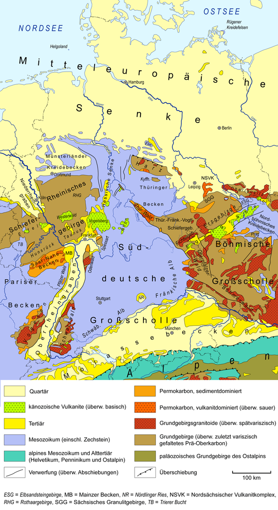
English: Simplified geological map of Germany and adjacent areas, based on Henningsen & Katzung (2006),[1] Pawlewicz et al. (2003)[2], GK 1000,[3] and Freudenberger et al. (1996).[4] Map Key/Legend : Quartär = Quaternary; känozoische Vulkanite (überw. basisch) = Cenozoic volcanic rocks (mainly basic);
Tertiär = Tertiary; Mesozoikum (einschl. Zechstein) = Mesozoic (including Zechstein); alpines Mesozoikum und Alttertiär (Helvetikum, Penninikum und Ostalpin) = Alpine Mesozoic and Paleogene (Helvetic, Penninic and Austroalpine nappes); Verwerfung (überw. Abschiebungen) = Fault (mainly normal faults); Permokarbon, sedimentdominiert = Permian-Carboniferous, sediment-dominated;
Permokarbon, vulkanitdominiert (überw. sauer) = Permian-Carboniferous, volcanics-dominated (predominantly acidic); Grundgebirgsgranitoide (überw. spätvariszisch) = Basement granitoids (predominantly late Variscan); Grundgebirge (überw. zuletzt variszisch gefaltetes Prä-Oberkarbon) = Basement (mostly latest Variscan folded pre-Upper Carboniferous); paläozoisches Grundgebirge des Ostalpins = Paleozoic basement of the Eastern Alps; Überschiebung = Thrust fault; Deutsch: Vereinfachte geologische Karte von Deutschland und angrenzenden Gebieten, basierend auf Henningsen & Katzung (2006),[1] Pawlewicz et al. (2003)[2], GK 1000.[3] und Freudenberger et al. (1996).[4]
|
| Date | |
| Source | Travail personnel |
| Auteur | Gretarsson |
Conditions d’utilisation
- Vous êtes libre :
- de partager – de copier, distribuer et transmettre cette œuvre
- d’adapter – de modifier cette œuvre
- Sous les conditions suivantes :
- paternité – Vous devez donner les informations appropriées concernant l'auteur, fournir un lien vers la licence et indiquer si des modifications ont été faites. Vous pouvez faire cela par tout moyen raisonnable, mais en aucune façon suggérant que l’auteur vous soutient ou approuve l’utilisation que vous en faites.
Historique du fichier
Cliquer sur une date et heure pour voir le fichier tel qu'il était à ce moment-là.
| Date et heure | Vignette | Dimensions | Utilisateur | Commentaire | |
|---|---|---|---|---|---|
| actuel | 8 août 2019 à 16:16 | | 2 495 × 4 577 (618 kio) | Gretarsson | some minor adjustments; added Danish-German border(!); compressed using tinyPNG.com before upload |
| 13 juillet 2016 à 20:33 |  | 2 495 × 4 577 (1,74 Mio) | Gretarsson | several minor fixes and minor additions | |
| 18 juin 2015 à 23:41 |  | 1 912 × 3 508 (2,35 Mio) | Gretarsson | Präzisierungen in der Legende | |
| 5 juin 2015 à 14:14 |  | 1 912 × 3 508 (2,36 Mio) | Gretarsson | kleinere Korrekturen/Ergänzungen in der Legende | |
| 2 juin 2015 à 21:57 |  | 1 912 × 3 508 (2,33 Mio) | Gretarsson | Legende: Korrektur der Beschreibung des varisz. Grundgebirges | |
| 2 juin 2015 à 20:41 |  | 1 912 × 3 508 (2,34 Mio) | Gretarsson | {{Information |Description ={{en|1=Geological sketch map of Germany and adjacent areas, based on Henningsen & Katzung (2006), USGS Surficial Geology of Europe and Geological Map of Germany 1:1,000,000 (GÜK 1000).}} {{de|1=Vereinfachte geologische K... |
Utilisation du fichier
La page suivante utilise ce fichier :
Usage global du fichier
Les autres wikis suivants utilisent ce fichier :
- Utilisation sur be.wikipedia.org
- Utilisation sur de.wikipedia.org
- Utilisation sur en.wikipedia.org
- Utilisation sur sk.wikipedia.org
- Utilisation sur uk.wikipedia.org