
Fichier:Fire-island-map.jpg
Taille de cet aperçu : 800 × 317 pixels. Autres résolutions : 320 × 127 pixels | 640 × 253 pixels | 1 024 × 405 pixels | 1 280 × 506 pixels | 3 493 × 1 382 pixels.
Fichier d’origine (3 493 × 1 382 pixels, taille du fichier : 363 kio, type MIME : image/jpeg)
Ce fichier et sa description proviennent de Wikimedia Commons.
Description
| Description |
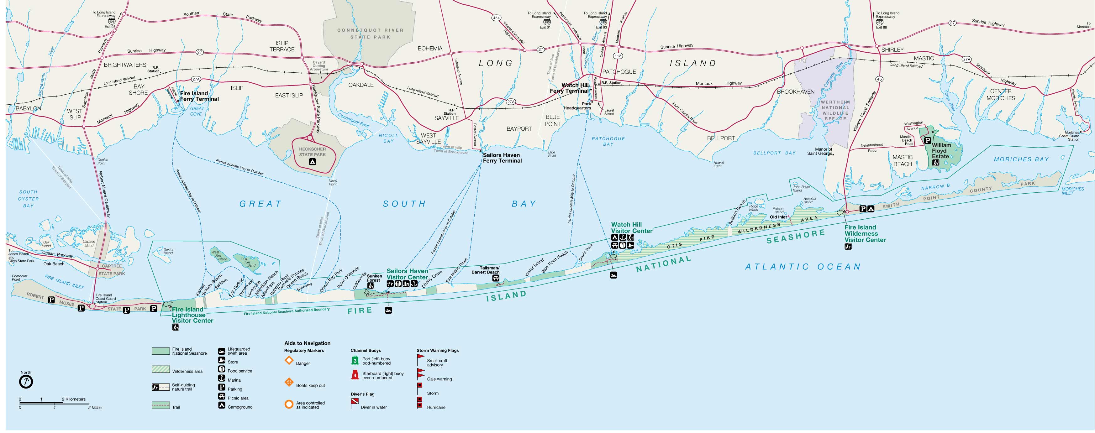
English: Fire Island map from USGS |
||
| Source | http://ny.cf.er.usgs.gov/nyprojectsearch/projects/2457-BUF-1.html | ||
| Créé par |
United States Geological Survey / Fire Island Inlet National Park |
||
| Géoréférencement | Si c'est inapproprié, définissez warp_status = skip pour masquer. | ||
| Autres versions |
|


Conditions d’utilisation
Cette image est placée dans le domaine public parce qu'elle contient des éléments issus de l'United States Geological Survey, une agence du Département de l'Intérieur des États-Unis. Pour plus d'information, consultez la politique officielle de copyright de l'USGS (en anglais)
|
Journal des téléversements d’origine
Transféré de en.wikipedia à Commons par Vmenkov utilisant CommonsHelper.
La page de description originale était ici. Tous les noms d'utilisateur qui suivent se rapportent à en.wikipedia.
- 2007-11-21 10:21 Americasroof 3493×1382× (371827 bytes) [[Fire Island, New York]] map from USGS http://ny.cf.er.usgs.gov/nyprojectsearch/projects/projectImages/2457-BUF-1_image002.jpg
Historique du fichier
Cliquer sur une date et heure pour voir le fichier tel qu'il était à ce moment-là.
| Date et heure | Vignette | Dimensions | Utilisateur | Commentaire | |
|---|---|---|---|---|---|
| actuel | 11 juin 2011 à 02:50 | 3 493 × 1 382 (363 kio) | File Upload Bot (Magnus Manske) | {{BotMoveToCommons|en.wikipedia|year={{subst:CURRENTYEAR}}|month={{subst:CURRENTMONTHNAME}}|day={{subst:CURRENTDAY}}}} {{Information |Description={{en|en:Fire Island, New York map from USGS}} |Source=Transferred from [http://en.wikipedia.org en.wik |
Utilisation du fichier
La page suivante utilise ce fichier :
Usage global du fichier
Les autres wikis suivants utilisent ce fichier :
- Utilisation sur ar.wikipedia.org
- Utilisation sur ceb.wikipedia.org
- Utilisation sur de.wikipedia.org
- Utilisation sur en.wikipedia.org
- Saltaire, New York
- Fire Island
- Fire Island National Seashore
- Fire Island Pines, New York
- Fair Harbor, New York
- Lonelyville, New York
- Patchogue Bay
- Watch Hill (New York)
- List of municipalities on Long Island
- Moriches Bay
- File talk:Fire-island-map.jpg
- Module:Location map/data/USA New York Fire Island/doc
- Module:Location map/data/USA New York Fire Island
- Utilisation sur fa.wikipedia.org
- Utilisation sur it.wikipedia.org
- Utilisation sur pl.wikipedia.org
- Utilisation sur si.wikipedia.org
- Utilisation sur war.wikipedia.org
- Utilisation sur www.wikidata.org
- Utilisation sur zh.wikipedia.org