
Fichier:Colombia.A2004117.1535.250m.jpg

Fichier d’origine (1 500 × 2 000 pixels, taille du fichier : 898 kio, type MIME : image/jpeg)
Ce fichier et sa description proviennent de Wikimedia Commons.
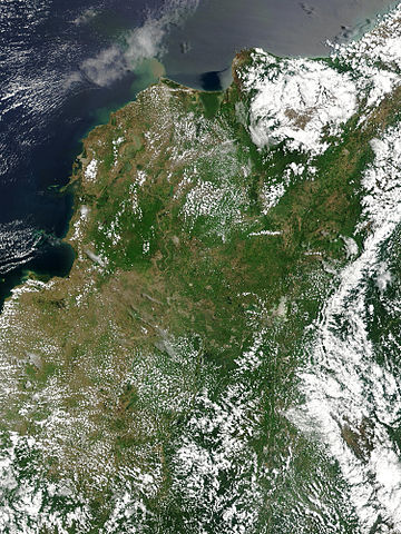
Floods in Colombia, April 2004.
Marshes and wetlands line Colombia’s Magdalena River in its course north from the Andes Mountains to the Caribbean Sea. The wetlands, which form black and blue patches along the river in the false color image, are important for birds arriving from the north for the winter. The area had received heavy rain which triggered floods and landslides. Though the floods aren't visible in these images, the tan plume of sediment flowing into the Caribbean from the Magdalena River in the true-color image may be a result of high, fast-moving waters carrying extra mud into the sea. This true and false color image pair was captured by the Moderate Resolution Imaging Spectroradiometer (MODIS) on the Aqua satellite on April 26, 2004.
http://visibleearth.nasa.gov/view_rec.php?id=6531 copie d'archive at the Wayback Machine
| Ce fichier provient de la NASA. Sauf exception, les documents créés par la NASA ne sont pas soumis à copyright. Pour plus d'informations, voir la politique de copyright de la NASA. | ||
 |
Attention :
|
Historique du fichier
Cliquer sur une date et heure pour voir le fichier tel qu'il était à ce moment-là.
| Date et heure | Vignette | Dimensions | Utilisateur | Commentaire | |
|---|---|---|---|---|---|
| actuel | 27 octobre 2005 à 21:36 | | 1 500 × 2 000 (898 kio) | Brian0918 | Floods in Colombia, April 2004. Marshes and wetlands line Colombia’s Magdalena River in its course north from the Andes Mountains to the Caribbean Sea. The wetlands, which form black and blue patches along the river in the false color image, are import |
Utilisation du fichier
La page suivante utilise ce fichier :
Usage global du fichier
Les autres wikis suivants utilisent ce fichier :
- Utilisation sur af.wikipedia.org
- Utilisation sur ar.wikipedia.org
- Utilisation sur el.wikipedia.org
- Utilisation sur en.wikipedia.org
- Utilisation sur ms.wikipedia.org
- Utilisation sur ru.wikipedia.org
- Utilisation sur sl.wikipedia.org
- Utilisation sur uk.wikipedia.org
- Utilisation sur vi.wikipedia.org