
Fichier:C73193s5 Ant.Map Mount Murchison.jpg

Taille de cet aperçu : 635 × 600 pixels. Autres résolutions : 254 × 240 pixels | 508 × 480 pixels | 813 × 768 pixels | 1 084 × 1 024 pixels | 2 168 × 2 048 pixels | 3 242 × 3 062 pixels.
Fichier d’origine (3 242 × 3 062 pixels, taille du fichier : 1,83 Mio, type MIME : image/jpeg)
Ce fichier et sa description proviennent de Wikimedia Commons.
Description
| Description |
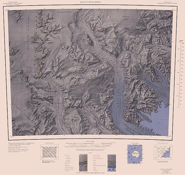
English: 1:250,000-scale topographic reconnaissance map of the Southern Cross Mountains area from 162°-166°30'E to 73°-74°S in Antarctica, including the Mountaineer Range with Mount Murchison, and Aviator and Campbell Glaciers. Mapped, edited and published by the U.S. Geological Survey in cooperation with the National Science Foundation. |
|||
| Date | ||||
| Source | http://usarc.usgs.gov/drg_dload.shtml | |||
| Auteur | United States Geological Survey | |||
| Autorisation (Réutilisation de ce fichier) |
|
Historique du fichier
Cliquer sur une date et heure pour voir le fichier tel qu'il était à ce moment-là.
| Date et heure | Vignette | Dimensions | Utilisateur | Commentaire | |
|---|---|---|---|---|---|
| actuel | 29 novembre 2015 à 16:45 | | 3 242 × 3 062 (1,83 Mio) | ValeriySh | Обрізка зайвого поля |
| 4 avril 2005 à 07:39 |  | 3 718 × 3 236 (1,82 Mio) | Achim Raschka | Map of Antarctica by the United States Antarctic Ressource Center of the US Geological Society. {{PD-US}} Copyrights and Trademarks USGS-authored or produced data and information are in the public domain. While the content of most USGS web pages is in th |
Utilisation du fichier
La page suivante utilise ce fichier :
Usage global du fichier
Les autres wikis suivants utilisent ce fichier :
- Utilisation sur bg.wikipedia.org
- Utilisation sur de.wikipedia.org
- Utilisation sur en.wikipedia.org
- Utilisation sur he.wikipedia.org
- Utilisation sur it.wikipedia.org
- Ghiacciaio Argonauta
- Ghiacciaio Meander
- Ghiacciaio Gair
- Ghiacciaio Oakley
- Ghiacciaio Dunn
- Ghiacciaio Finley
- Ghiacciaio Icebreaker
- Ghiacciaio Fitzgerald
- Dorsale dell'Alpinista
- Ghiacciaio Parker
- Ghiacciaio Aviator
- Ghiacciaio Pilot
- Ghiacciaio Cosmonaut
- Ghiacciaio Shoemaker
- Ghiacciaio Astronaut
- Ghiacciaio Cosmonette
Voir davantage sur l’utilisation globale de ce fichier.