
Fichier:Box culvert on Old Route 180. Looking NE. - Petrified Forest National Park Roads and Bridges, Holbrook, Navajo County, AZ HAER AZ-58-25.tif

Fichier d’origine (5 225 × 4 263 pixels, taille du fichier : 21,25 Mio, type MIME : image/tiff)
Ce fichier et sa description proviennent de Wikimedia Commons.
Description
| Box culvert on Old Route 180. Looking NE. - Petrified Forest National Park Roads and Bridges, Holbrook, Navajo County, AZ | ||||
|---|---|---|---|---|
| Photographe |
Grogan, Brian Related names:
|
|||
| Titre |
Box culvert on Old Route 180. Looking NE. - Petrified Forest National Park Roads and Bridges, Holbrook, Navajo County, AZ |
|||
| Lieu représenté | Arizona; Navajo County; Holbrook | |||
| Date | 2001 | |||
| Dimensions | 4 x 5 in. | |||
| Lieu actuel |
Library of Congress Prints and Photographs Division Washington, D.C. 20540 USA http://hdl.loc.gov/loc.pnp/pp.print |
|||
| Numéro d’inventaire |
HAER AZ-58-25 |
|||
| Attribution de l’acquisition |
|
|||
| Notes |
The design and construction of the roads and bridges at Petrified Forest National Park reflect larger national trends, including the shift from rail tourism to auto travel and the increasing post-World War II reliance on roads for economic gain, including heritage tourism. The history of their construction reflects the application of New Deal work programs to improve the nation's transportation system, as well as the later infusion of federal funding as part of the "Mission 66" initiative. The roads and bridges reflect the prodigious effort by planners to imbue the American driving experience with education opportunities, scenic beauty and recreational relaxation.
|
|||
| Source | https://www.loc.gov/pictures/item/az0476.photos.193703p | |||
| Autorisation (Réutilisation de ce fichier) |
|
|||

| Position de l'objet | | Voir cet endroit et d’autres images sur : OpenStreetMap |
|---|
Historique du fichier
Cliquer sur une date et heure pour voir le fichier tel qu'il était à ce moment-là.
| Date et heure | Vignette | Dimensions | Utilisateur | Commentaire | |
|---|---|---|---|---|---|
| actuel | 2 juillet 2014 à 00:13 | 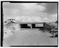 | 5 225 × 4 263 (21,25 Mio) | Fæ | GWToolset: Creating mediafile for Fæ. HABS 1 July 2014 (201:300) |
Utilisation du fichier
La page suivante utilise ce fichier :