
Fichier:Ash and Steam Plume, Soufriere Hills Volcano, Montserrat.jpg
Fichier d’origine (2 598 × 2 039 pixels, taille du fichier : 1,61 Mio, type MIME : image/jpeg)
Ce fichier et sa description proviennent de Wikimedia Commons.
Description
| Description |
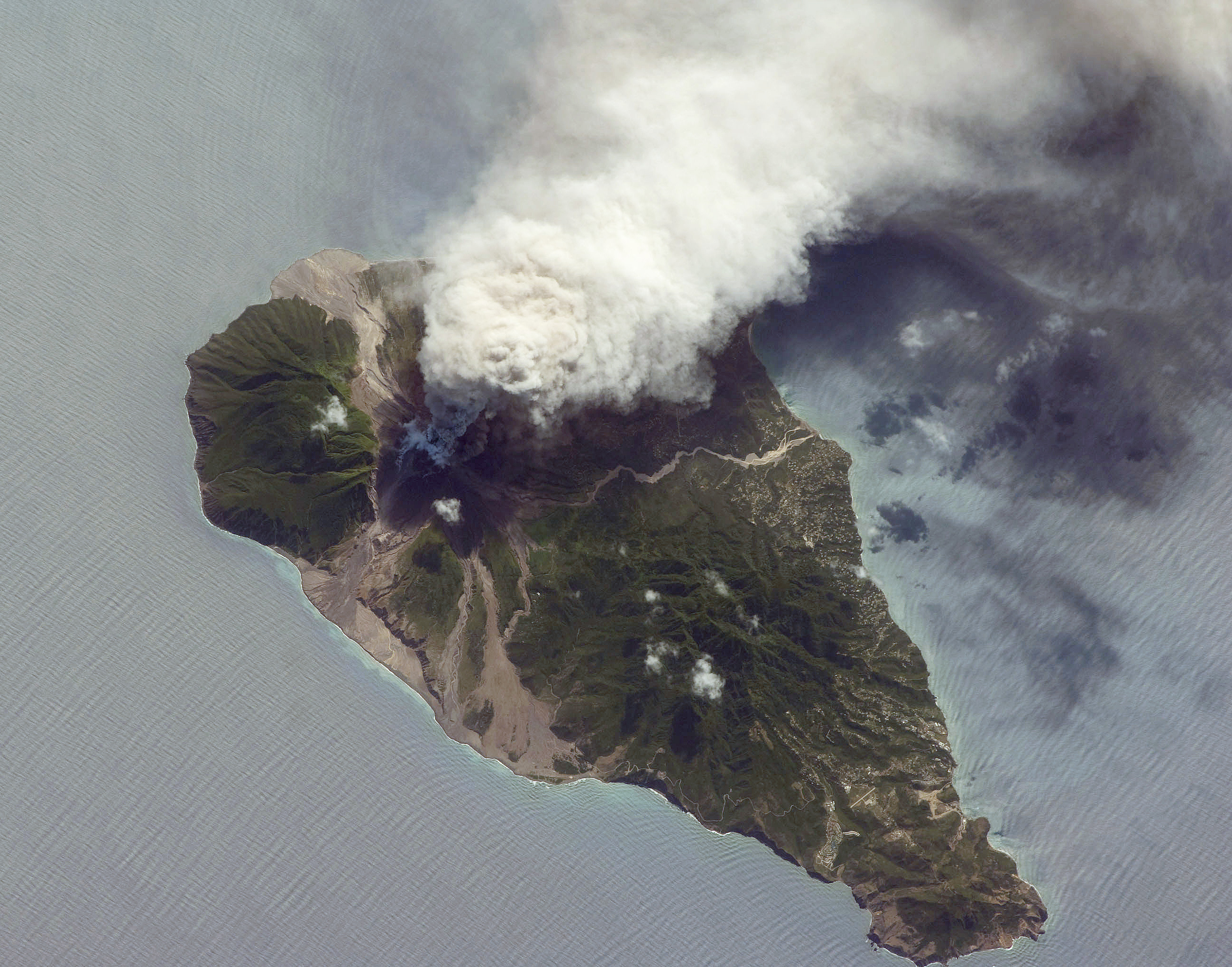
English: This oblique astronaut photograph from the International Space Station (ISS) captures a white-to-grey ash and steam plume extending westwards from the volcano. Oblique images are taken by astronauts looking out from the ISS at an angle, rather than looking straight downward toward the Earth (a perspective called a nadir view), as is common with most remotely sensed data from satellites. An oblique view gives the scene a more three-dimension quality, and provides a look at the vertical structure of the volcanic plume. While much of the island is covered in green vegetation, grey deposits that include pyroclastic flows and volcanic mud-flows (lahars) are visible extending from the volcano toward the coastline. When compared to its extent in earlier views, the volcanic debris has filled in more of the eastern coastline. Urban areas are visible in the northern and western portions of the island; they are recognizable by linear street patterns and the presence of bright building rooftops. The silver-grey appearance of the Caribbean Sea surface is due to sun-glint, which is the mirror-like reflection of sunlight off the water surface back towards the hand-held camera on-board the ISS. The sun-glint highlights surface wave patterns around the island.
|
||||||||||||||||||||||||||||||||||||||||||||||||||||||
| Date | |||||||||||||||||||||||||||||||||||||||||||||||||||||||
| Source | NASA Earth Observatory | ||||||||||||||||||||||||||||||||||||||||||||||||||||||
| Auteur | Image taken by the NASA Expedition 21 crew | ||||||||||||||||||||||||||||||||||||||||||||||||||||||
| Lieu de la prise de vue | | Voir cet endroit et d’autres images sur : OpenStreetMap |
|---|
Cette image ou vidéo a été cataloguée par le Johnson Space Center de la National Aeronautics and Space Administration (NASA) des États-Unis sous Photo ID : ISS021-E-5555.Ce bandeau n’indique rien sur le statut de l’œuvre au regard du droit d'auteur. Un bandeau de droit d’auteur est requis. Voir Commons:À propos des licences pour plus d’informations. Autres langues :
|
Image acquired with a Nikon D2Xs digital camera fitted with a 400 mm lens, and is provided by the ISS Crew Earth Observations experiment and Image Science & Analysis Laboratory, Johnson Space Centre.
Conditions d’utilisation
| Ce fichier provient de la NASA. Sauf exception, les documents créés par la NASA ne sont pas soumis à copyright. Pour plus d'informations, voir la politique de copyright de la NASA. | ||
 |
Attention :
|
Historique du fichier
Cliquer sur une date et heure pour voir le fichier tel qu'il était à ce moment-là.
| Date et heure | Vignette | Dimensions | Utilisateur | Commentaire | |
|---|---|---|---|---|---|
| actuel | 19 octobre 2009 à 12:26 | | 2 598 × 2 039 (1,61 Mio) | Originalwana | {{Information |Description={{en|1=This oblique astronaut photograph from the International Space Station (ISS) captures a white-to-grey ash and steam plume extending westwards from the |
Utilisation du fichier
La page suivante utilise ce fichier :
Usage global du fichier
Les autres wikis suivants utilisent ce fichier :
- Utilisation sur de.wikipedia.org
- Utilisation sur el.wikipedia.org
- Utilisation sur en.wikiversity.org
- User:Marshallsumter/Radiation astronomy1/Planets/Sciences
- Draft:Keynote lectures/Satellites for radiation astronomy
- Draft:Original research/Astrogeology
- Planets/Geology
- User:Marshallsumter/Radiation astronomy2/Rocks
- Gases/Gaseous objects/Earth
- Radiation/Astronomy
- User:Marshallsumter/Radiation astronomy2/Satellites
- User:Marshallsumter/Radiation astronomy2/Reflections
- User:Marshallsumter/Radiation astronomy/Earth
- Orbital platforms
- Utilisation sur hy.wikipedia.org
- Utilisation sur no.wikipedia.org
- Utilisation sur oc.wikipedia.org
- Utilisation sur ru.wikipedia.org