
Fichier:Arab-Israeli Map1.png

Taille de cet aperçu : 800 × 427 pixels. Autres résolutions : 320 × 171 pixels | 640 × 342 pixels | 1 090 × 582 pixels.
Fichier d’origine (1 090 × 582 pixels, taille du fichier : 115 kio, type MIME : image/png)
Ce fichier et sa description proviennent de Wikimedia Commons.
Description
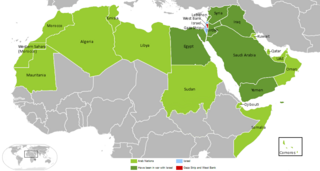
Arab-Israeli Map
Copied from en:Image:Arab-Israeli_Map1.GIF, uploaded by en:User:Arab League on 14:45, 18 August 2006 .
For other version, see Image:Arab Israeli Conflict 4.png
Conditions d’utilisation
| Cette œuvre a été placée dans le domaine public par son auteur, Arab League sur Wikipédia anglais. Ceci s’applique dans le monde entier. Dans certains pays, ceci peut ne pas être possible ; dans ce cas : Arab League accorde à toute personne le droit d’utiliser cette œuvre dans n’importe quel but, sans aucune condition, sauf celles requises par la loi. |
Journal des téléversements d’origine
| Date et heure | Dimensions | Utilisateur | Commentaire |
|---|---|---|---|
| 1er décembre 2006, 17:12:36 | 819 × 466 (15860 bytes) | Milan.sk (d · contributions) |
Historique du fichier
Cliquer sur une date et heure pour voir le fichier tel qu'il était à ce moment-là.
| Date et heure | Vignette | Dimensions | Utilisateur | Commentaire | |
|---|---|---|---|---|---|
| actuel | 29 mars 2018 à 01:09 | | 1 090 × 582 (115 kio) | Maphobbyist | South Sudan border in the little world map |
| 19 mars 2018 à 23:55 |  | 1 090 × 582 (92 kio) | Maphobbyist | Modern borders of Turkey, because Hatay Province is part of Turkey since 1939 and borders of South Sudan which became independent in 2011. | |
| 18 mars 2018 à 22:36 |  | 819 × 466 (17 kio) | Maphobbyist | Reverted to version as of 19:39, 17 August 2014 (UTC) | |
| 21 janvier 2017 à 14:18 |  | 800 × 455 (131 kio) | عادل | correction of Egypt borders | |
| 17 août 2014 à 21:39 |  | 819 × 466 (17 kio) | GifTagger | Bot: Converting file to superior PNG file. (Source: Arab-Israeli_Map1.GIF). This GIF was problematic due to non-greyscale color table. |
Utilisation du fichier
Les 2 pages suivantes utilisent ce fichier :
Usage global du fichier
Les autres wikis suivants utilisent ce fichier :
- Utilisation sur en.wikipedia.org
- Utilisation sur sq.wikipedia.org