
Fichier:Ambrym, South Pacific Ocean ESA380358.tiff

Fichier d’origine (5 396 × 4 912 pixels, taille du fichier : 151,69 Mio, type MIME : image/tiff)
Ce fichier et sa description proviennent de Wikimedia Commons.
Description
| Description |
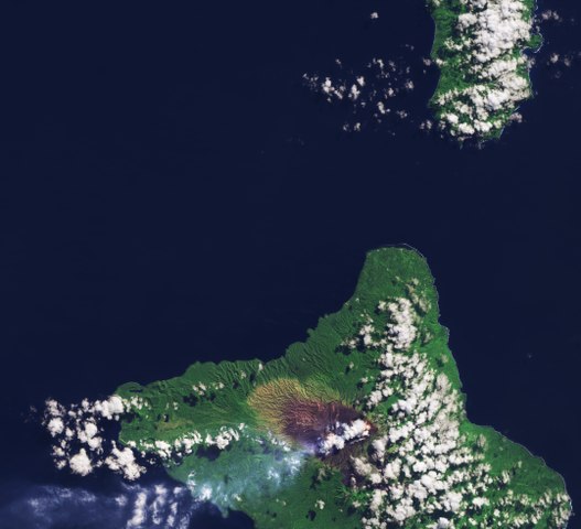
English: Sentinel-2A takes us to the Vanuatu archipelago in the South Pacific Ocean, roughly 1700 km east of Australia.
The islands we see are Pentecost to the north and Ambrym to the south. Looking closely at the coastline, the white of breaking waves is more evident on the east coasts of the islands than on the west coasts. This is a common observation on islands that lie in the zone of the trade winds blowing mainly from south-easterly directions in the southern hemisphere. Zooming in on the dark area on Ambrym, red-hot lava lakes can be seen through the clouds. This volcano has two active volcanic cones and we can see smoke drifting out over the ocean to the west. The last time the Ambrym volcano erupted was in 1913, prompting the evacuation of nearby towns. Ambrym’s 12 km-wide caldera was created around 50 AD by a large Plinian eruption – also called a ‘Vesuvian’ eruption because of the similarity with the explosion of Italy’s Mount Vesuvius that destroyed the towns of Pompeii and Herculaneum. These types of eruptions are marked by columns of gas and ash that extend high into the stratosphere. They also eject large amounts of pumice. The volcano’s slopes appear black owing to the presence of basalt. As we move further away from the volcano the land becomes greener owing to the increased vegetation cover. Sentinel-2 is able to systematically map different classes of cover such as forest, crops, grassland, water surfaces and artificial cover like roads and buildings. This information can be used to manage natural resources, to check rates of deforestation, reforestation and areas affected by wildfires. It can also help governing bodies and commercial enterprises make informed decisions about how best to manage, protect and sustain our important forest resources. This image, also featured on theEarth from Space video programme, was captured by the Copernicus Sentinel-2A satellite on 24 June 2016. |
| Date | |
| Source | http://www.esa.int/spaceinimages/Images/2017/06/Ambrym_South_Pacific_Ocean |
| Auteur | European Space Agency |
| Autorisation (Réutilisation de ce fichier) |
contains modified Copernicus Sentinel data (2016), processed by ESA,CC BY-SA 3.0 IGO |
| Autres versions |
|
| Title | Ambrym, South Pacific Ocean |
| Set | Earth observation image of the week |
| System | Copernicus |
| Mission | Sentinel-2 |
| Location | Pacific ocean |
| Activity | Observing the Earth |
| Keywords | Archipelago; Islands; Volcanoes; Satellite image |

Conditions d’utilisation
- Vous êtes libre :
- de partager – de copier, distribuer et transmettre cette œuvre
- d’adapter – de modifier cette œuvre
- Sous les conditions suivantes :
- paternité – Vous devez donner les informations appropriées concernant l'auteur, fournir un lien vers la licence et indiquer si des modifications ont été faites. Vous pouvez faire cela par tout moyen raisonnable, mais en aucune façon suggérant que l’auteur vous soutient ou approuve l’utilisation que vous en faites.
- partage à l’identique – Si vous modifiez, transformez, ou vous basez sur cette œuvre, vous devez distribuer votre contribution sous la même licence ou une licence compatible avec celle de l’original.

|
This image contains data from a satellite in the Copernicus Programme, such as Sentinel-1, Sentinel-2 or Sentinel-3. Attribution is required when using this image.
Attribution: Contains modified Copernicus Sentinel data {{{year}}}
The use of Copernicus Sentinel Data is regulated under EU law (Commission Delegated Regulation (EU) No 1159/2013 and Regulation (EU) No 377/2014). Relevant excerpts:
Free access shall be given to GMES dedicated data [...] made available through GMES dissemination platforms [...].
Access to GMES dedicated data [...] shall be given for the purpose of the following use in so far as it is lawful:
GMES dedicated data [...] may be used worldwide without limitations in time.
GMES dedicated data and GMES service information are provided to users without any express or implied warranty, including as regards quality and suitability for any purpose. |
Historique du fichier
Cliquer sur une date et heure pour voir le fichier tel qu'il était à ce moment-là.
| Date et heure | Vignette | Dimensions | Utilisateur | Commentaire | |
|---|---|---|---|---|---|
| actuel | 30 juin 2017 à 12:34 |  | 5 396 × 4 912 (151,69 Mio) | Fæ | European Space Agency, Id 380358, http://www.esa.int/spaceinimages/Images/2017/06/Ambrym_South_Pacific_Ocean, User:Fæ/Project_list/ESA |
Utilisation du fichier
La page suivante utilise ce fichier :
Usage global du fichier
Les autres wikis suivants utilisent ce fichier :
- Utilisation sur www.wikidata.org