
Fichier:20180302-FS-LSC-0360 (42211299152).jpg

Taille de cet aperçu : 800 × 450 pixels. Autres résolutions : 320 × 180 pixels | 640 × 360 pixels | 1 024 × 576 pixels | 1 280 × 720 pixels | 2 560 × 1 440 pixels | 5 031 × 2 830 pixels.
Fichier d’origine (5 031 × 2 830 pixels, taille du fichier : 9,65 Mio, type MIME : image/jpeg)
Ce fichier et sa description proviennent de Wikimedia Commons.
.jpg?uselang=fr)
Description
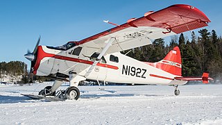
| Description | The U.S. Department of Agriculture (USDA) Forest Service's (FS) only seaplane base and its fleet of de Havilland Beaver DHC-2 aircraft in the Superior National Forest (NF) Kawishiwi Ranger District at Ely, MN, on March 2, 2018. Centrally located, the base provides fast response to all regions of Superior NF. The planes were built between 1956 and 1959. During the winter season, the floats on the plane are switched to skis, and their duties then includes tracking various species of animals using wing strut mounted antennas to home in on transmitters worn by the animals and responding to emergencies. During warmer months, the mission includes wildlife surveys, search and rescue, reconnaissance, medical evacuation, tree seeding, cargo delivery, fish stocking and wildland firefighter squad insertion to remote lakes. During the warm seasons, they patrol the forest and when possible respond to small fires by using a float mounted pipe to fill a 120-gallon underbelly water tank in several seconds then dropping it on the fire. Superior NF was established in 1909, the Superior is known for its boreal forest ecosystem, numerous clean lakes, and a colorful cultural history. Management by the USDA-Forest Service, under principles of ecosystem management and multiple use, the Forest provides for a diverse community of plants and animals as well as products for human needs. The concept of "all lands" management maintains strong partnerships and collaboration across the landscape. Popular recreational activities include fishing, hunting, camping, canoeing, swimming, hiking, snowmobiling, cross country skiing and ice fishing. Superior NF System is 2,174,993 acres. USDA Photo by Lance Cheung. |
| Date | |
| Source | 20180302-FS-LSC-0360 |
| Auteur | Forest Service, USDA |
| Lieu de la prise de vue | | Voir cet endroit et d’autres images sur : OpenStreetMap |
|---|
.jpg¶ms=047.904850_N_-091.883913_E_globe:Earth_type:camera_alt:410_source:exif_&language=fr)
Conditions d’utilisation
This image is a work of the Forest Service of the United States Department of Agriculture. As a work of the U.S. federal government, the image is in the public domain.
|
| Cette image a été originellement postée sur Flickr par Forest Service Photography à l'adresse https://flickr.com/photos/140082569@N07/42211299152 (archives). Elle a été passée en revue le 25 octobre 2019 par le robot FlickreviewR 2, qui a confirmé qu'elle se trouvait sous licence Public Domain Mark. |
Historique du fichier
Cliquer sur une date et heure pour voir le fichier tel qu'il était à ce moment-là.
| Date et heure | Vignette | Dimensions | Utilisateur | Commentaire | |
|---|---|---|---|---|---|
| actuel | 22 octobre 2019 à 03:18 | | 5 031 × 2 830 (9,65 Mio) | Ser Amantio di Nicolao | Transferred from Flickr via #flickr2commons |
Utilisation du fichier
La page suivante utilise ce fichier :
Usage global du fichier
Les autres wikis suivants utilisent ce fichier :
- Utilisation sur fr.wiktionary.org
.jpg)