
Fichier:1853 Kaei 6 Japanese Map of the World - Geographicus - ChikyuBankokuHozu-nakajima-1853.jpg

Taille de cet aperçu : 800 × 466 pixels. Autres résolutions : 320 × 186 pixels | 640 × 372 pixels | 1 024 × 596 pixels | 1 280 × 745 pixels | 2 560 × 1 490 pixels | 6 000 × 3 492 pixels.
Fichier d’origine (6 000 × 3 492 pixels, taille du fichier : 5,51 Mio, type MIME : image/jpeg)
Ce fichier et sa description proviennent de Wikimedia Commons.
Description
| Shintei - Chikyu Bankoku Hozu (Square Map of all the Countries on the Globe) | |||
|---|---|---|---|
| Artiste | |||
| Titre |
Shintei - Chikyu Bankoku Hozu (Square Map of all the Countries on the Globe) |
||
| Description |
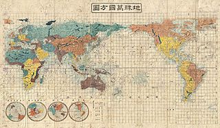
English: A very interesting 1853 (Kaei 6) Japanese world map by Suido Nakajima. Presented on a cylindrical projection, this map marks a significant advancement in Japanese globular cartography and a far more sophisticated adaptation of western cartographic standards than is evidenced in most earlier Japanese world maps. No longer reliant on 17th century Dutch maps acquired via the Dutch East India Company’s (VOC) trade concession in Nagasaki, the Japanese have here abandoned many of the antiquated cartographic notions, such as an insular California, which were common in Japanese maps of the previous decade. Japanese cartographers may have been motivated to update their traditional world view in the light of the explosion of cartographic ideas associated with the arrival in Edo Harbor of the American Commodore Matthew Perry in the same year this map was published. As a whole this map offers a sophisticated cartographic presentation of the world embracing the most up to date cartographic knowledge available in the mid-19th century. Though adapted to the Japanese printing style, this map presents a generally accurate world view. British Claims to Washington and British Columbia are noted in North America, Australia and the Pacific are accurately rendered, as are the discoveries of Vitus Bering and James Cook in the Arctic, and Africa is clearly pre-Speke. The disputed East Sea / Sea of Japan / Sea of Korea is here labeled as the Sea of Joseon (Korea), which some scholars suggests indicates Japanese acceptance of the “Sea of Korea” convention. Four hemispheres appear in the lower left quadrant, from left, the southern, northern, eastern, and western. All are on a stereographic projection. The map is printed on woodblock and hand colored in vivid, blues, greens, oranges, and yellows. A fine example of the redefined Japanese cartography style of the later Tokugawa period. |
||
| Date | 1853 (dated Kaei 6) | ||
| Dimensions | hauteur : 31 pouces (78,7 cm) ; largeur : 51 pouces (129,5 cm) | ||
| Numéro d’inventaire |
liens Geographicus : ChikyuBankokuHozu-nakajima-1853 |
||
| Source / photographe |
|
||
Conditions d’utilisation
|
Ceci est une reproduction photographique fidèle d'une œuvre d'art originale en deux dimensions. L'œuvre d'art elle-même est dans le domaine public pour la raison suivante :
La position officielle de la Fondation Wikimedia est que « les représentations fidèles des œuvres d'art du domaine public en deux dimensions sont dans le domaine public et les exigences contraires sont une attaque contre le concept même de domaine public ». Pour plus de détails, voir Commons:Quand utiliser le bandeau PD-Art.
Cette reproduction photographique est donc également considérée comme étant élevée dans le domaine public. Merci de noter qu'en fonction des lois locales, la réutilisation de ce contenu peut être interdite ou restreinte dans votre juridiction. Voyez Commons:Reuse of PD-Art photographs. | ||||
Historique du fichier
Cliquer sur une date et heure pour voir le fichier tel qu'il était à ce moment-là.
| Date et heure | Vignette | Dimensions | Utilisateur | Commentaire | |
|---|---|---|---|---|---|
| actuel | 25 mars 2011 à 07:07 | | 6 000 × 3 492 (5,51 Mio) | BotMultichillT | {{subst:User:Multichill/Geographicus |link=http://www.geographicus.com/P/AntiqueMap/ChikyuBankokuHozu-nakajima-1853 |product_name=1853 Kaei 6 Japanese Map of the World |map_title=Shintei - Chikyu Bankoku Hozu (Square Map of all the Countries on the Globe) |
Utilisation du fichier
La page suivante utilise ce fichier :
Usage global du fichier
Les autres wikis suivants utilisent ce fichier :
- Utilisation sur ja.wikipedia.org
- Utilisation sur zh.wikipedia.org