Fichier:1794 Delarochette Wall Map of the Empire of Germany - Geographicus - Germany-delarochette-1794.jpg

Le contenu de la page n’est pas pris en charge dans d’autres langues.
Une page de Wikipédia, l'encyclopédie libre.

Fichier d’origine(8 000 × 7 128 pixels, taille du fichier : 20,36 Mio, type MIME : image/jpeg)

Ce fichier et sa description proviennent de Wikimedia Commons.

Description

Avertissement Certains navigateurs peuvent avoir des difficultés à afficher cette image à sa résolution complète : elle possède un nombre de pixels singulièrement élevé et peut ne pas se charger correctement ou faire planter votre navigateur.
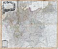
Map of the Empire of Germany, Including All the States Comprehended under that Name: with the Kingdom of Prussia, &c.
Artiste
Titre
Map of the Empire of Germany, Including All the States Comprehended under that Name: with the Kingdom of Prussia, &c.
Description
English: An absolutely stunning and monumental two panel 1794 wall map of Germany, Bohemia, Austria and Prussia by Louis Stanislas d'Arcy Delarochette. Covers Germanic territories in full from the Baltic Sea to the Gulf of Venice. Includes Germany, Austria, Bohemia (Czech Republic), Poland, Lithuania, Prussia, Switzerland, Holland (the Netherlands), Belgium and Denmark. Offers an extraordinary level of detail throughout, noting roadways, towns, castles, monasteries, forests, swamps, rivers, cities and mountains. Even offers some offshore detail near Belgium and Holland. An elaborate allegorical title cartouche in the upper left quadrant depicts the German janiform eagle overlooking two warrior women and an assortment of military paraphernalia. Under it all, a baleful Medusa looks on. this is the 1794 updated edition of a map originally published in 1759. Published by Laurie and Whittle as plate nos. 18-19 in the 1797 edition of Thomas Kitchin's General Atlas .
Date 1794 (dated)
Dimensions hauteur : 42 pouces (106,6 cm) ; largeur : 48 pouces (121,9 cm)
dimensions QS:P2048,42U218593
dimensions QS:P2049,48U218593
Numéro d’inventaire
liens Geographicus : Germany-delarochette-1794
Source / photographe

Kitchin, Thomas, Kitchin's General Atlas, describing the Whole Universe: being a complete collection of the most approved maps extant; corrected with the greatest care, and augmented from the last edition of D'Anville and Robert with many improvements by other eminent geographers, engraved on Sixty-Two plates, comprising Thirty Seven maps., Laurie & Whittle, London, 1797.

Autres versions

Conditions d’utilisation

Public domain

Cette œuvre est également dans le domaine public dans tous les pays pour lesquels le droit d’auteur a une durée de vie de 100 ans ou moins après la mort de l’auteur.


Cette œuvre est dans le domaine public aux États-Unis car elle a été publiée avant le 1er janvier 1929.

Légendes

Ajoutez en une ligne la description de ce que représente ce fichier

Éléments décrits dans ce fichier

dépeint

image/jpeg

660cfd2be177945653ef4bb05150f2172e403fc1

21 350 322 octet

7 128 pixel

8 000 pixel

Historique du fichier

Cliquer sur une date et heure pour voir le fichier tel qu'il était à ce moment-là.

Date et heureVignetteDimensionsUtilisateurCommentaire
actuel23 mars 2011 à 06:50Vignette pour la version du 23 mars 2011 à 06:508 000 × 7 128 (20,36 Mio)BotMultichillT{{subst:User:Multichill/Geographicus |link=http://www.geographicus.com/P/AntiqueMap/Germany-delarochette-1794 |product_name=1794 Delarochette Wall Map of the Empire of Germany |map_title=Map of the Empire of Germany, Including All the States Comprehended

La page suivante utilise ce fichier :

Usage global du fichier

Les autres wikis suivants utilisent ce fichier :