
Fichier:12-INCH VERTICAL PUG MILL, MANUFACTURED BY THE CROSSLEY MANUFACTURING CO. OF TRENTON, NJ. IT WAS PURCHASED IN 1902, AND USED AT THE FIRST MORAVIAN POTTERY AND TILE WORKS BEFORE HAER PA,9-DOYLT.V,8-28.tif

Taille de cet aperçu JPG pour ce fichier TIF : 800 × 571 pixels. Autres résolutions : 320 × 228 pixels | 640 × 457 pixels | 1 024 × 731 pixels | 1 280 × 914 pixels | 2 560 × 1 827 pixels | 5 000 × 3 569 pixels.
Fichier d’origine (5 000 × 3 569 pixels, taille du fichier : 17,02 Mio, type MIME : image/tiff)
Ce fichier et sa description proviennent de Wikimedia Commons.
Description
| Photographe |
Lowe, Jet |
|||
| Titre |
12-INCH VERTICAL PUG MILL, MANUFACTURED BY THE CROSSLEY MANUFACTURING CO. OF TRENTON, NJ. IT WAS PURCHASED IN 1902, AND USED AT THE FIRST MORAVIAN POTTERY AND TILE WORKS BEFORE BEING MOVED TO IS PRESENT LOCATION IN 1912. AFTER THE PURCHASE OF THE BRICK AUGER, IT WAS PROBABLY USED TO MIX PIGMENT INTO BUFF CLAY TO PRODUCE COLORED-BODIED CLAYS. - Moravian Pottery and Tile Works, Southwest side of State Route 313 (Swamp Road), Northwest of East Court Street, Doylestown, Bucks County, PA |
|||
| Description |
Mercer, Henry Chapman; Swain, Frank King; Briddes, John; Sell, Herman; American Clay Machinery Company; Crossley Manufacturing Company; Donegan and Swift; Orr and Sembower; Buck, Raymond; Swain, Frank H; Bucks County Department of Parks and Recreation; Bailey Pottery Equipment Corporation; DeLony, Eric N, project manager; Bucks County Board of Commissioners, sponsor; Bucks County Department of Parks and Recreation, sponsor; Welch, Benita C, delineator; Driscoll, David B, historian; Baiges, Mabel A, delineator; Boyd, Dermot G, delineator; Claytor, Leslie S, delineator; Lowe, Jet, photographer |
|||
| Lieu représenté | Pennsylvania; Bucks County; Doylestown | |||
| Date | 1987 | |||
| Dimensions | 5 x 7 in. | |||
| Lieu actuel |
Library of Congress Prints and Photographs Division Washington, D.C. 20540 USA http://hdl.loc.gov/loc.pnp/pp.print |
|||
| Numéro d’inventaire |
HAER PA,9-DOYLT.V,8-28 |
|||
| Attribution de l’acquisition |
|
|||
| Notes |
|
|||
| Références |
|
|||
| Source | https://www.loc.gov/pictures/item/pa3690.photos.142912p | |||
| Autorisation (Réutilisation de ce fichier) |
|

| Position de l'objet | | Voir cet endroit et d’autres images sur : OpenStreetMap |
|---|
Historique du fichier
Cliquer sur une date et heure pour voir le fichier tel qu'il était à ce moment-là.
| Date et heure | Vignette | Dimensions | Utilisateur | Commentaire | |
|---|---|---|---|---|---|
| actuel | 1 août 2014 à 07:25 | 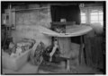 | 5 000 × 3 569 (17,02 Mio) | Fæ | GWToolset: Creating mediafile for Fæ. HABS 31 July 2014 (3000:3200) |
Utilisation du fichier
La page suivante utilise ce fichier :
Usage global du fichier
Les autres wikis suivants utilisent ce fichier :
- Utilisation sur en.wikipedia.org