
Fichier:Wfm james ross straight.png

Taille de cet aperçu : 800 × 593 pixels. Autres résolutions : 320 × 237 pixels | 640 × 474 pixels | 1 024 × 758 pixels | 1 280 × 948 pixels.
Fichier d’origine (1 280 × 948 pixels, taille du fichier : 2,7 Mio, type MIME : image/png)
Ce fichier et sa description proviennent de Wikimedia Commons.
Description
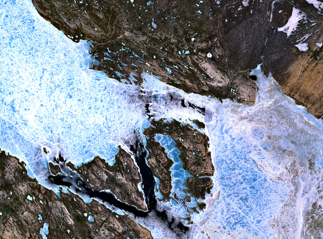
The James Ross Straight northeast of King William Island. Sea ice fills the straight, forming a bridge to Tennent Island (in the west) and Matty Island (further to the east).
NASA Landsat 7 satellite image, collected using NASA World Wind.
Conditions d’utilisation
| Cette image est dans le domaine public car elle est constituée d'une capture d'écran du logiciel World Wind de la NASA qui utilise des données du domaine public, comme Blue Marble, MODIS, Landsat, SRTM, USGS ou GLOBE.
|
 |
Historique du fichier
Cliquer sur une date et heure pour voir le fichier tel qu'il était à ce moment-là.
| Date et heure | Vignette | Dimensions | Utilisateur | Commentaire | |
|---|---|---|---|---|---|
| actuel | 2 septembre 2005 à 20:38 | | 1 280 × 948 (2,7 Mio) | Finlay McWalter | The James Ross Straight northeast of en:King William Island. Sea ice fills the straight, forming a bridge to Tennent Island (in the west) and Matty Island (further to the east). NASA Landsat 7 satellite image, collected using NASA World Wind. |
Utilisation du fichier
La page suivante utilise ce fichier :
Usage global du fichier
Les autres wikis suivants utilisent ce fichier :
- Utilisation sur bg.wikipedia.org
- Utilisation sur de.wikipedia.org
- Utilisation sur en.wikipedia.org
- Utilisation sur es.wikipedia.org
- Utilisation sur fi.wikipedia.org
- Utilisation sur it.wikipedia.org
- Utilisation sur ja.wikipedia.org
- Utilisation sur ml.wikipedia.org
- Utilisation sur nl.wikipedia.org
- Utilisation sur pt.wikipedia.org
- Utilisation sur ru.wikipedia.org
- Utilisation sur zh.wikipedia.org