
Fichier:LocationSouthAfrica-1990.png
Pas de plus haute résolution disponible.
LocationSouthAfrica-1990.png (250 × 115 pixels, taille du fichier : 5 kio, type MIME : image/png)
Ce fichier et sa description proviennent de Wikimedia Commons.

|
Une version vectorielle de cette image existe, dans le format « SVG ». Si elle n’est pas inférieure, elle devrait être utilisée à la place de la présente version pour des affichages en plus grandes dimensions ou nécessitant une meilleure résolution.
File:LocationSouthAfrica-1990.png → File:South Africa in its region (1990).svg
Pour plus d’informations sur les images vectorielles, consultez la page de transition de Commons vers le format SVG. Voir aussi les informations à propos de la manière dont le logiciel MediaWiki gère les images au format SVG. |
.svg) |
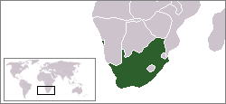
Description
A locator map of South Africa showing en:Walvis Bay. This locator map is intended for South African articles taking place before the transfer of Walvis Bay to Namibia in 1994. The orginal map is by Vardion. Since that map is PD, this one is well.
Conditions d’utilisation
| Cette œuvre a été placée dans le domaine public par son auteur, Hoshie. Ceci s’applique dans le monde entier. Dans certains pays, ceci peut ne pas être possible ; dans ce cas : |
Historique du fichier
Cliquer sur une date et heure pour voir le fichier tel qu'il était à ce moment-là.
| Date et heure | Vignette | Dimensions | Utilisateur | Commentaire | |
|---|---|---|---|---|---|
| actuel | 17 décembre 2009 à 09:26 | | 250 × 115 (5 kio) | Hoshie | Reverted to version as of 03:34, 16 August 2006 rv, Nambia itself wasn't a part of S. Africa |
| 2 décembre 2008 à 20:37 |  | 250 × 115 (5 kio) | ChrisDHDR | South Africa included Namibia at the time | |
| 16 août 2006 à 05:34 |  | 250 × 115 (5 kio) | Hoshie | == Summary == A locator map of South Africa showing en:Walvis Bay. This locator map is intended for South African articles taking place before the transfer of Walvis Bay to Nambia in 1994. The orginal map is by [[Us |
Utilisation du fichier
Aucune page n’utilise ce fichier.