
Fichier:GrosseSeekarspitzePano.jpg

Taille de cet aperçu : 800 × 96 pixels. Autres résolutions : 320 × 38 pixels | 640 × 77 pixels.
Fichier d’origine (4 997 × 600 pixels, taille du fichier : 987 kio, type MIME : image/jpeg)
Ce fichier et sa description proviennent de Wikimedia Commons.
Description
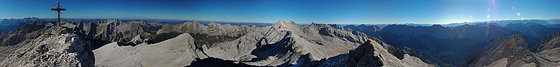
| Description |
English: Panoramic view from Große Seekarspitze (Karwendel) to Birkkarspitze (view annotations) and mountains in the main chain. Birkköpfe in the South of Ödkarspitze. Northern ridge of Karwendel in the left half of the photo (from far, beyond Karwendel valley), with the Kuhkopf, optical near the 3 Ödkarspitzen and Birkkarspitze. A far view to Zugspitze and Wetterstein in the West (left). The dark blue green valley in the right side is Hinterautal (upper oberste Isar), the lower steep blue mountain ridge Roßlochkamm (Gamskarspitze, Brantlspitze rise up from Roßloch-Alm. |
| Date | |
| Source | photo taken by Kogo |
| Auteur | Kogo |
| Autorisation (Réutilisation de ce fichier) |
Kogo put it under the GFDL |
| Lieu de la prise de vue | | Voir cet endroit et d’autres images sur : OpenStreetMap |
|---|

|
Vous avez la permission de copier, distribuer et modifier ce document selon les termes de la GNU Free Documentation License version 1.2 ou toute version ultérieure publiée par la Free Software Foundation, sans sections inaltérables, sans texte de première page de couverture et sans texte de dernière page de couverture. Un exemplaire de la licence est inclus dans la section intitulée GNU Free Documentation License. |
| Annotations | Cette image est annotée : Voir les annotations sur Wikimedia Commons |


.jpg)
Historique du fichier
Cliquer sur une date et heure pour voir le fichier tel qu'il était à ce moment-là.
| Date et heure | Vignette | Dimensions | Utilisateur | Commentaire | |
|---|---|---|---|---|---|
| actuel | 19 novembre 2005 à 18:13 | 4 997 × 600 (987 kio) | Kogo |
Utilisation du fichier
La page suivante utilise ce fichier :
Usage global du fichier
Les autres wikis suivants utilisent ce fichier :
- Utilisation sur de.wikipedia.org
- Utilisation sur en.wikipedia.org
- Utilisation sur nl.wikipedia.org