
Fichier:Cyclades map-fr.svg

Taille de cet aperçu PNG pour ce fichier SVG : 509 × 600 pixels. Autres résolutions : 204 × 240 pixels | 407 × 480 pixels | 652 × 768 pixels | 869 × 1 024 pixels | 1 738 × 2 048 pixels | 3 680 × 4 335 pixels.
Fichier d’origine (Fichier SVG, nominalement de 3 680 × 4 335 pixels, taille : 2,74 Mio)
Ce fichier et sa description proviennent de Wikimedia Commons.
Description
| Description |
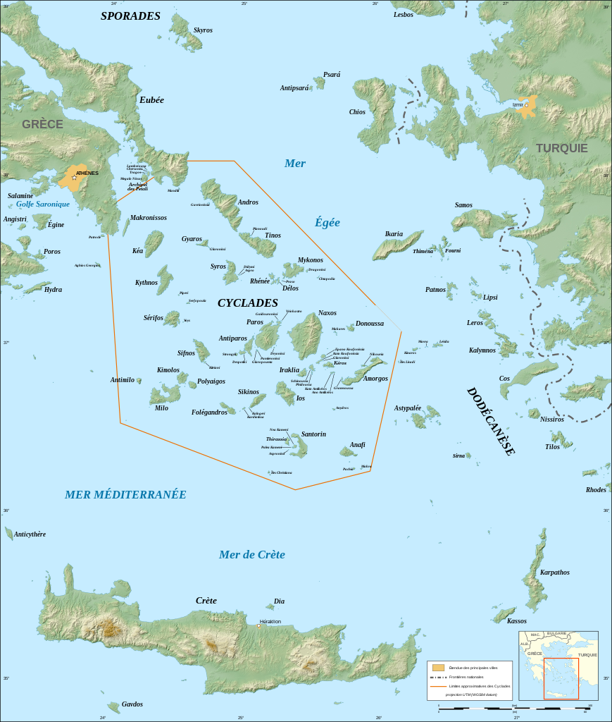
English: Map in French of the Cyclades islands, Greece.
Note: The background map is a raster image embedded in the SVG file. Français : Carte des îles Cyclades, Grèce.
UTM projection ; WGS84 datum ; shaded reliefNote : La carte de fond est une image embarquée dans le fichier SVG. |
||
| Date | |||
| Source |
Own work ;
|
||
| Auteur | Eric Gaba (Sting - fr:Sting) | ||
| Autorisation (Réutilisation de ce fichier) |
|
||
| Autres versions |
|


|
Ce fichier SVG contient du texte encapsulé pouvant facilement être traduit dans votre langue en utilisant n'importe quel éditeur de fichier SVG ou de texte, ou par l'outil de traduction de fichiers SVG. Pour plus d'informations, voir : A propos de la traduction des fichiers SVG. |
Conditions d’utilisation
Moi, en tant que détenteur des droits d’auteur sur cette œuvre, je la publie sous les licences suivantes :

|
Vous avez la permission de copier, distribuer et modifier ce document selon les termes de la GNU Free Documentation License version 1.2 ou toute version ultérieure publiée par la Free Software Foundation, sans sections inaltérables, sans texte de première page de couverture et sans texte de dernière page de couverture. Un exemplaire de la licence est inclus dans la section intitulée GNU Free Documentation License. |
Ce fichier est sous licence Creative Commons Attribution – Partage dans les Mêmes Conditions 3.0 (non transposée), 2.5 Générique, 2.0 Générique et 1.0 Générique.
- Vous êtes libre :
- de partager – de copier, distribuer et transmettre cette œuvre
- d’adapter – de modifier cette œuvre
- Sous les conditions suivantes :
- paternité – Vous devez donner les informations appropriées concernant l'auteur, fournir un lien vers la licence et indiquer si des modifications ont été faites. Vous pouvez faire cela par tout moyen raisonnable, mais en aucune façon suggérant que l’auteur vous soutient ou approuve l’utilisation que vous en faites.
- partage à l’identique – Si vous modifiez, transformez, ou vous basez sur cette œuvre, vous devez distribuer votre contribution sous la même licence ou une licence compatible avec celle de l’original.
Vous pouvez choisir l’une de ces licences.
Historique du fichier
Cliquer sur une date et heure pour voir le fichier tel qu'il était à ce moment-là.
| Date et heure | Vignette | Dimensions | Utilisateur | Commentaire | |
|---|---|---|---|---|---|
| actuel | 4 septembre 2008 à 19:44 | | 3 680 × 4 335 (2,74 Mio) | Sting | Fully standardized colors |
| 1 septembre 2008 à 04:26 |  | 3 680 × 4 335 (2,77 Mio) | Sting | Little bug | |
| 1 septembre 2008 à 03:40 |  | 3 680 × 4 335 (2,77 Mio) | Sting | Some new standard colors | |
| 28 septembre 2007 à 23:11 |  | 3 680 × 4 335 (2,79 Mio) | Sting | Typo ; added island names ; Cyclades limits correction | |
| 25 septembre 2007 à 05:37 |  | 3 680 × 4 335 (2,76 Mio) | Sting | Text issues | |
| 25 septembre 2007 à 05:24 |  | 3 680 × 4 335 (2,77 Mio) | Sting | Again | |
| 25 septembre 2007 à 05:05 |  | 512 × 603 (2,77 Mio) | Sting | Map size issues | |
| 25 septembre 2007 à 04:45 |  | 512 × 603 (2,77 Mio) | Sting | {{Information |Description=Map in French of the Cyclades islands, Greece |Source=Own work ;<br/>Topographic background map : [http://www2.jpl.nasa.gov/srtm NASA Shuttle Radar Topography Mission] (SRTM3 v.2) (public domain) edited with [http://www.visualiz |
Utilisation du fichier
Aucune page n’utilise ce fichier.
Usage global du fichier
Les autres wikis suivants utilisent ce fichier :
- Utilisation sur ca.wikipedia.org
- Utilisation sur en.wikipedia.org
- Utilisation sur es.wikipedia.org
- Utilisation sur et.wikipedia.org
- Utilisation sur pt.wikibooks.org
- Utilisation sur uk.wikipedia.org