
Fichier:Wenro Territory ca1630 map-en.svg

Taille de cet aperçu PNG pour ce fichier SVG : 800 × 591 pixels. Autres résolutions : 320 × 237 pixels | 640 × 473 pixels | 1 024 × 757 pixels | 1 280 × 946 pixels | 2 560 × 1 892 pixels | 2 300 × 1 700 pixels.
Fichier d’origine (Fichier SVG, nominalement de 2 300 × 1 700 pixels, taille : 9,76 Mio)
Ce fichier et sa description proviennent de Wikimedia Commons.
Description
| Description |
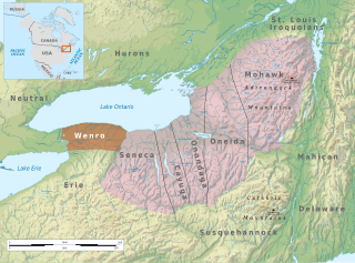
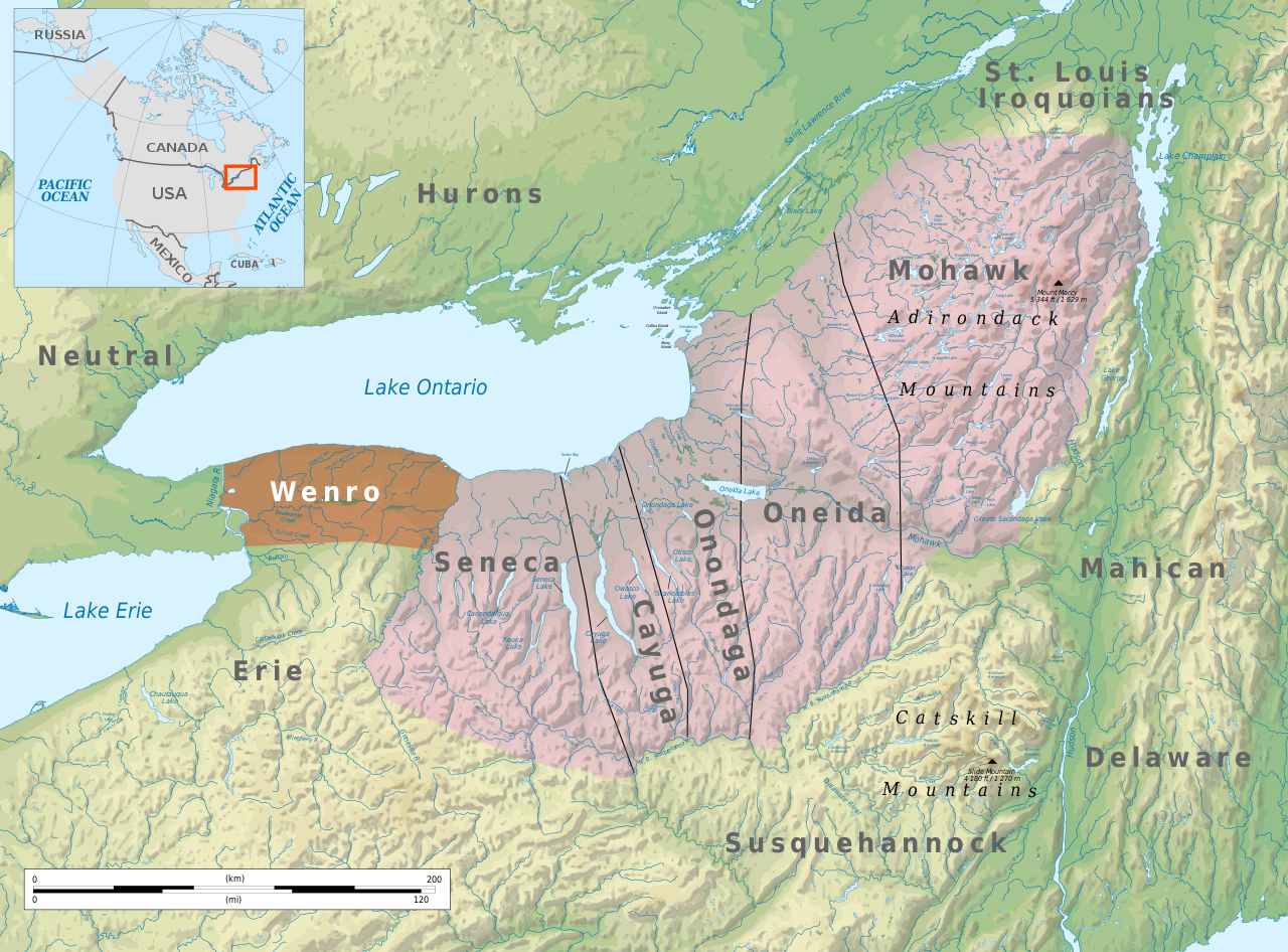
English: Tribal territory of Wenro about 1630 |
| Date | |
| Source | Travail personnel based on Geographic map of New York state |
| Auteur | Ikonact |
| Autorisation (Réutilisation de ce fichier) |
Any use of this map is subject of the license(s) stated below with the condition that you credit (Wikimedia Commons user: Ikonact) as the author . A message with a reply address would also be greatly appreciated. |
| SVG information |
Conditions d’utilisation
Moi, en tant que détenteur des droits d’auteur sur cette œuvre, je la publie sous la licence suivante :
Ce fichier est sous la licence Creative Commons Attribution – Partage dans les Mêmes Conditions 4.0 International.
- Vous êtes libre :
- de partager – de copier, distribuer et transmettre cette œuvre
- d’adapter – de modifier cette œuvre
- Sous les conditions suivantes :
- paternité – Vous devez donner les informations appropriées concernant l'auteur, fournir un lien vers la licence et indiquer si des modifications ont été faites. Vous pouvez faire cela par tout moyen raisonnable, mais en aucune façon suggérant que l’auteur vous soutient ou approuve l’utilisation que vous en faites.
- partage à l’identique – Si vous modifiez, transformez, ou vous basez sur cette œuvre, vous devez distribuer votre contribution sous la même licence ou une licence compatible avec celle de l’original.
| Annotations | Cette image est annotée : Voir les annotations sur Wikimedia Commons |
Historique du fichier
Cliquer sur une date et heure pour voir le fichier tel qu'il était à ce moment-là.
| Date et heure | Vignette | Dimensions | Utilisateur | Commentaire | |
|---|---|---|---|---|---|
| actuel | 6 juin 2021 à 23:14 | | 2 300 × 1 700 (9,76 Mio) | Ikonact | css adapted for translation |
| 6 juin 2021 à 23:09 |  | 2 300 × 1 700 (9,76 Mio) | Ikonact | corrections | |
| 6 juin 2021 à 22:44 |  | 2 300 × 1 700 (9,76 Mio) | Ikonact | valid svg | |
| 6 juin 2021 à 22:33 |  | 2 300 × 1 700 (9,76 Mio) | Ikonact | some more details | |
| 6 juin 2021 à 00:44 |  | 2 300 × 1 700 (10,33 Mio) | Ikonact | labels | |
| 6 juin 2021 à 00:37 |  | 2 300 × 1 700 (10,33 Mio) | Ikonact | == {{int:filedesc}} == {{Information |description={{en|Tribal territory of Wenro about 1630}} |date=2021-06-06 |source={{own}} based on Geographic map of New York state |author={{U|Ikonact}} |permission=Any use of this map is subject of the license(s) stated below with the condition that you credit ({{U|Ikonact|Wikimedia Commons user: Ikonact}}) as the author . A [http://commons.wikimedia.org/w/index.php?title=User_talk:Ikonact&action=edit§io... |
Utilisation du fichier
La page suivante utilise ce fichier :
Usage global du fichier
Les autres wikis suivants utilisent ce fichier :
- Utilisation sur be.wikipedia.org
- Utilisation sur bg.wikipedia.org
- Utilisation sur ca.wikipedia.org
- Utilisation sur de.wikipedia.org
- Utilisation sur en.wikipedia.org
- Utilisation sur fi.wikipedia.org
- Utilisation sur hr.wikipedia.org
- Utilisation sur no.wikipedia.org
- Utilisation sur sv.wikipedia.org