
Fichier:Ushas Mons.jpg

Taille de cet aperçu : 480 × 600 pixels. Autres résolutions : 192 × 240 pixels | 384 × 480 pixels | 614 × 768 pixels | 819 × 1 024 pixels | 1 638 × 2 048 pixels | 4 096 × 5 120 pixels.
Fichier d’origine (4 096 × 5 120 pixels, taille du fichier : 5,17 Mio, type MIME : image/jpeg)
Ce fichier et sa description proviennent de Wikimedia Commons.
Description
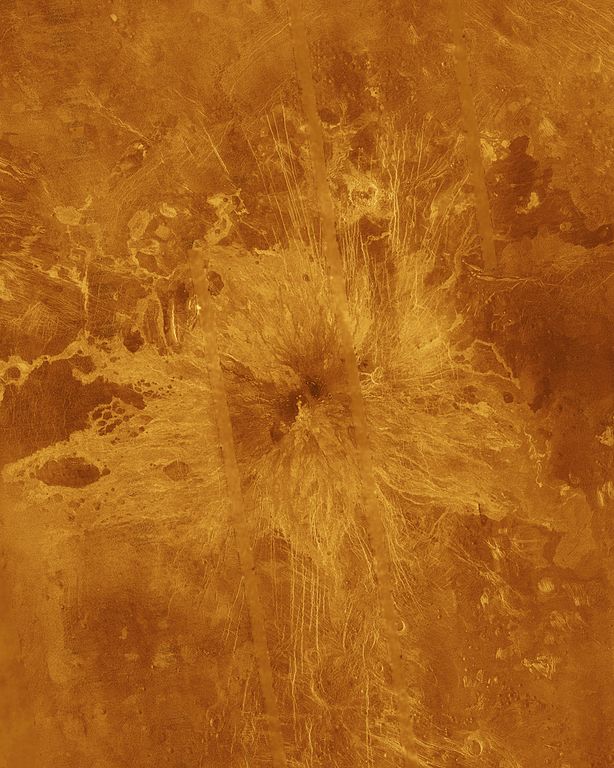
| Description | Ushas Mons, a 2-kilometer-high (1.25 mile) volcano in the southern hemisphere of Venus is shown in this Magellan radar image. The image is centered at 25 degrees south latitude, 323 degrees east longitude, and shows an area approximately 600 kilometers (360 miles) on a side. The volcano is marked by numerous bright lava flows and a set of north-south trending fractures, many of which appear to have formed after the lavas were erupted onto the surface. In the central summit area, however, younger flows remain unfractured. An impact crater can be seen among the fractures in the upper center of the image. The association of faulting and volcanism is common on this type of volcano on Venus, and is believed to result from a large zone of hot material upwelling from the Venusian mantle, a phenomenon known on Earth as a "hot spot." Simulated color is used to enhance small-scale structures. The simulated hues are based on color images recorded by the Venera 13 and 14 landing craft. The data were acquired during the third eight-month cycle of Magellan's radar mapping, which ended in September 1992. Several narrow gaps in the Magellan coverage are filled with low-resolution radar data obtained by the Earth-based Arecibo radio telescope. The image was produced by the Solar System Visualization Project and the Magellan Science Team at the Jet Propulsion Multimission Image Processing Laboratory. The Magellan mission is managed by JPL for NASA's Office of Space Science. |
| Source | http://photojournal.jpl.nasa.gov/catalog/PIA00272 |
| Auteur | JPL/NASA |
Cette image ou vidéo a été cataloguée par le Jet Propulsion Lab de la National Aeronautics and Space Administration (NASA) des États-Unis sous Photo ID : PIA00272.Ce bandeau n’indique rien sur le statut de l’œuvre au regard du droit d'auteur. Un bandeau de droit d’auteur est requis. Voir Commons:À propos des licences pour plus d’informations. Autres langues :
|
Conditions d’utilisation
| Ce fichier provient de la NASA. Sauf exception, les documents créés par la NASA ne sont pas soumis à copyright. Pour plus d'informations, voir la politique de copyright de la NASA. | ||
 |
Attention :
|
Historique du fichier
Cliquer sur une date et heure pour voir le fichier tel qu'il était à ce moment-là.
| Date et heure | Vignette | Dimensions | Utilisateur | Commentaire | |
|---|---|---|---|---|---|
| actuel | 9 février 2012 à 19:32 | | 4 096 × 5 120 (5,17 Mio) | Lotse | higher resolution |
| 25 novembre 2007 à 01:48 |  | 516 × 645 (47 kio) | Lotse | {{Information |Description= Ushas Mons, a 2-kilometer-high (1.25 mile) volcano in the southern hemisphere of Venus is shown in this Magellan radar image. The image is centered at 25 degrees south latitude, 323 degrees east longitude, and shows an area |
Utilisation du fichier
La page suivante utilise ce fichier :
Usage global du fichier
Les autres wikis suivants utilisent ce fichier :
- Utilisation sur ar.wikipedia.org
- Utilisation sur de.wikipedia.org
- Utilisation sur en.wikipedia.org
- Utilisation sur es.wikipedia.org
- Utilisation sur gl.wikipedia.org
- Utilisation sur it.wikipedia.org
- Utilisation sur nl.wikipedia.org
- Utilisation sur pt.wikipedia.org
- Utilisation sur uk.wikipedia.org
- Utilisation sur www.wikidata.org
- Utilisation sur zh.wikipedia.org