
Fichier:Typus orbis terrarum - Norman B. Leventhal Map Center at the BPL.jpg

Taille de cet aperçu : 800 × 600 pixels. Autres résolutions : 320 × 240 pixels | 640 × 480 pixels | 1 024 × 768 pixels | 1 280 × 960 pixels | 2 560 × 1 920 pixels | 10 880 × 8 160 pixels.
Fichier d’origine (10 880 × 8 160 pixels, taille du fichier : 25,55 Mio, type MIME : image/jpeg)
Ce fichier et sa description proviennent de Wikimedia Commons.
Description
| Avertissement | Certains navigateurs peuvent avoir des difficultés à afficher cette image à sa résolution complète : elle possède un nombre de pixels singulièrement élevé et peut ne pas se charger correctement ou faire planter votre navigateur. |
|---|
| Description |
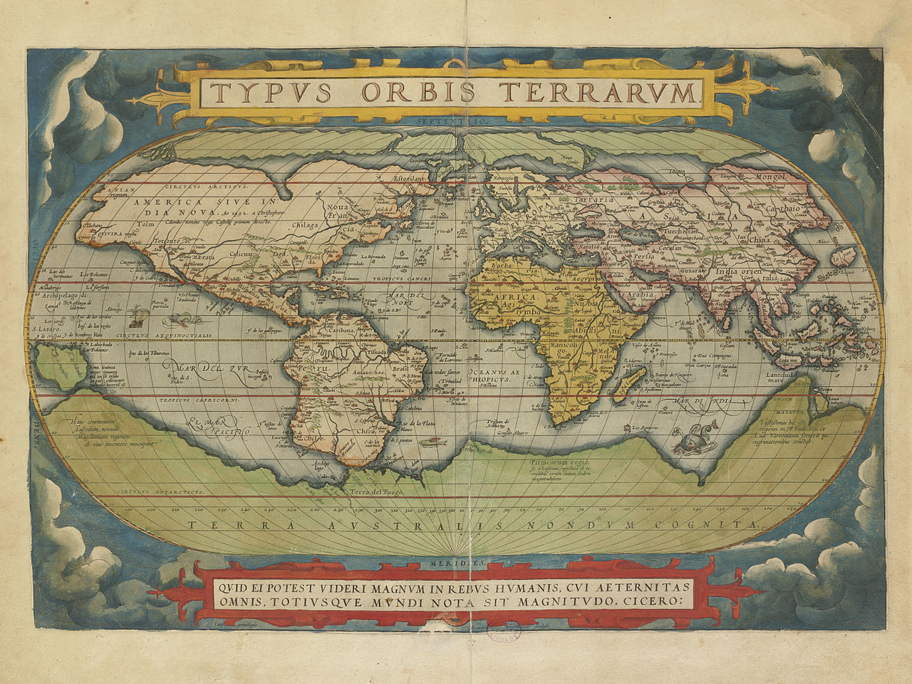
Zoom into this map at maps.bpl.org. Author: Ortelius, Abraham Publisher: A. Ortelius Date: 1570.
BPL Call Number: G1006 .T54 1570 View at the Norman B. Leventhal Map Center Ortelius' book of maps, first published in 1570, is considered the first modern world atlas. It was the first time that a set of maps, contemporary to the date of publication, was designed, drawn, and engraved with the intention of publishing them in a bound volume. Ortelius did not refer to his publication as an "atlas," as we know it today. Rather he entitled it "Theater of the World" implying not only that the entire known world could be viewed in this one book, but that the Earth was a stage on which human actions unfolded. Although most of the maps in this book pertain to European countries and provinces, it can be considered a world atlas because it also includes a map of the world (displayed here), as well as one map for each of the four continents. This world map was based on a large 21-sheet world map published by Ortelius' colleague, Gerard Mercator the year before. It displayed almost a century of European exploration in the Americas delineating relatively accurate coast lines in the Equatorial areas, but with greatly distorted shapes in southern South America and northern and western North America. Interestingly, the map prematurely showed a southern polar continent since the southern oceans had not yet been explored. The projected southern continent was based on the reports of Magellan sighting Terra del Fuego when he rounded the tip of South America and the accounts of early Dutch discoveries along the Australian coast. While the first edition of Ortelius' Theatrum Orbis Terrarum was published in Latin in 1570, this map book was subsequently issued in 33 editions over the next 41 years. It was also translated into six other languages -- German, Dutch, French, Spanish, Italian, and English. The success of this first "atlas" publication marked the beginning of the golden age of Flemish and Dutch cartography with cartographers from the Low Countries dominating the map trade until the end of the 17th century. |
| Date | |
| Source | Typus orbis terrarum |
| Auteur | http://maps.bpl.org |
Conditions d’utilisation
Ce fichier est disponible selon les termes de la licence Creative Commons Attribution 2.0 Générique.
- Vous êtes libre :
- de partager – de copier, distribuer et transmettre cette œuvre
- d’adapter – de modifier cette œuvre
- Sous les conditions suivantes :
- paternité – Vous devez donner les informations appropriées concernant l'auteur, fournir un lien vers la licence et indiquer si des modifications ont été faites. Vous pouvez faire cela par tout moyen raisonnable, mais en aucune façon suggérant que l’auteur vous soutient ou approuve l’utilisation que vous en faites.
| Cette image a été originellement postée sur Flickr par Norman B. Leventhal Map Center at the BPL à l'adresse https://www.flickr.com/photos/24528911@N05/2710792122. Elle a été passée en revue le 2 juillet 2012 par le robot FlickreviewR, qui a confirmé qu'elle se trouvait sous licence cc-by-2.0. |
Historique du fichier
Cliquer sur une date et heure pour voir le fichier tel qu'il était à ce moment-là.
| Date et heure | Vignette | Dimensions | Utilisateur | Commentaire | |
|---|---|---|---|---|---|
| actuel | 26 août 2014 à 11:38 | | 10 880 × 8 160 (25,55 Mio) | Joopr | Geconverteerd JP2 bestand in zo groot mogelijke resolutie. Geplaatst omdat de oorspronkelijke webpagina (tijdelijk?) niet meer beschikbaar is. |
| 2 juillet 2012 à 03:42 |  | 1 200 × 900 (352 kio) | Dzlinker | == {{int:filedesc}} == {{Information |Description=Zoom into [http://maps.bpl.org/id/M8747/ this map] at [http://maps.bpl.org maps.bpl.org]. '''Author:''' Ortelius, Abraham '''Publisher:''' A. Ortelius '''Date:''' 1570. '''Scale:''' Scale not given. '... |
Utilisation du fichier
La page suivante utilise ce fichier :
Usage global du fichier
Les autres wikis suivants utilisent ce fichier :
- Utilisation sur en.wikipedia.org