
Fichier:Tri-State Tornado map.PNG
Taille de cet aperçu : 735 × 600 pixels. Autres résolutions : 294 × 240 pixels | 589 × 480 pixels | 852 × 695 pixels.
Fichier d’origine (852 × 695 pixels, taille du fichier : 61 kio, type MIME : image/png)
Ce fichier et sa description proviennent de Wikimedia Commons.
Description
| Description |
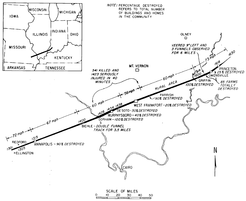
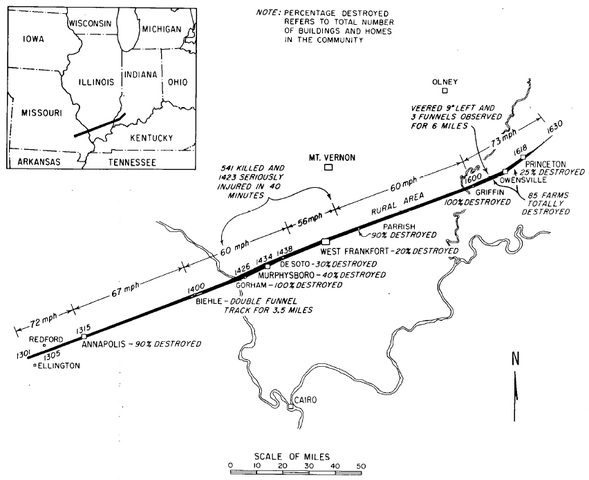
English: Original track map of the 219-mile, 3.5 hour Tri-State Tornado which killed 695 in Missouri, Illinois, and Indiana on 18 March 1925. |
| Date | |
| Source | Illinois Tornadoes. Circular 103. Illinois State Water Survey: Urbana-Champaign, IL. |
| Auteur | Wilson, John W., and Stanley A. Changnon, Jr. |
Conditions d’utilisation
Ce média est dans le domaine public des États-Unis d’Amérique car son auteur est l’administration américaine comme précisé dans le code fédéral au Titre 17, Chapitre 1, Section 105. Pour en savoir plus : droit d’auteur.
Attention : Ceci ne concerne que le travail du Gouvernement Fédéral et pas celui des États, ou d’une autre subdivision géographique ou politique du pays.
|
 | |
| Ce fichier a été identifié comme étant exempt de restrictions connues liées au droit d’auteur, y compris tous les droits connexes et voisins. | ||
Historique du fichier
Cliquer sur une date et heure pour voir le fichier tel qu'il était à ce moment-là.
| Date et heure | Vignette | Dimensions | Utilisateur | Commentaire | |
|---|---|---|---|---|---|
| actuel | 15 novembre 2006 à 05:14 | | 852 × 695 (61 kio) | Skyodyssey~commonswiki | Original track map of the 219-mile, 3.5 hour Tri-State Tornado which killed 695 in Missouri, Illinois, and Indiana on 18 March 1925. Wilson, John W., and Stanley A. Changnon, Jr. (1971). Illinois Tornadoes. Circular 103. Illinois State Water Survey: Urba |
Utilisation du fichier
La page suivante utilise ce fichier :