
Fichier:SEUtahStrat.JPG

Taille de cet aperçu : 800 × 454 pixels. Autres résolutions : 320 × 182 pixels | 640 × 363 pixels | 1 024 × 581 pixels | 1 280 × 726 pixels | 3 161 × 1 794 pixels.
Fichier d’origine (3 161 × 1 794 pixels, taille du fichier : 2,5 Mio, type MIME : image/jpeg)
Ce fichier et sa description proviennent de Wikimedia Commons.
Description
| Description |
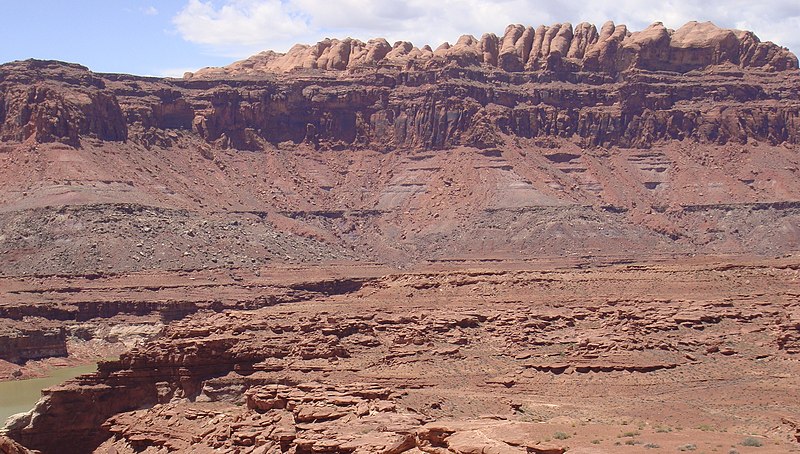
English: The Permian (bottom) through Jurassic (top) stratigraphy of the Colorado Plateau area of southeastern Utah that makes up much of the famous prominent rock formations in protected areas such as Capitol Reef National Park and Canyonlands National Park.
From top to bottom: Rounded tan domes of the Navajo Sandstone, layered red Kayenta Formation, cliff-forming, vertically-jointed, red Wingate Sandstone, slope-forming, purplish Chinle Formation, layered, lighter-red Moenkopi Formation, and white, layered Cutler Formation sandstone. Picture from Glen Canyon National Recreation Area, Utah. (modified version, 26MAY-2012, after change on en:Moenkopi Formation; changing (3) to a (3A,3B), with explanations, because of the larger photo RED debris visible.) The en:Jurassic through en:Permian stratigraphy of the Colorado Plateau area of southeastern Utah that makes up much of the famous prominent rock formations in protected areas such as Capitol Reef National Park and Canyonlands National Park. From top to bottom, (Jurassic to Permian): (6)-Rounded tan domes of the Navajo Sandstone, (5)-(very-dark)-layered red Kayenta Formation, (4)-(very-dark)-cliff-forming, vertically-jointed, red Wingate Sandstone, (3B)-(RED debris covered)-slope-forming, purplish Chinle Formation, (3A)-(NO RED Debris)-slope-forming, purplish Chinle Formation, (2)-layered, lighter-red Moenkopi Formation, and (1)-white, layered Cutler Formation sandstone. Picture from Glen Canyon National Recreation Area, Utah.)- (this makes 7 Layers, or there are 6 Layers with 3A, and 3B) |
| Date | (UTC) (Uploaded on Commons at 2011-03-27 17:26:30 (UTC)/Original uploaded at 2010-05-20 16:46:26) |
| Source | I (Matt Affolter (QFL247) (talk)) created this work entirely by myself. (Original uploaded on en.wikipedia) |
| Auteur | Matt Affolter (QFL247) (talk) (Transferred by Citypeek/Original uploaded by Matt Affolter (QFL247)) |
Conditions d’utilisation
Matt Affolter (QFL247), en tant que détenteur des droits d’auteur sur cette œuvre, la publie sous les licences suivantes :
Ce fichier est disponible selon les termes de la licence Creative Commons Attribution – Partage dans les Mêmes Conditions 3.0 (non transposée).
Attribution: Matt Affolter (QFL247)
- Vous êtes libre :
- de partager – de copier, distribuer et transmettre cette œuvre
- d’adapter – de modifier cette œuvre
- Sous les conditions suivantes :
- paternité – Vous devez donner les informations appropriées concernant l'auteur, fournir un lien vers la licence et indiquer si des modifications ont été faites. Vous pouvez faire cela par tout moyen raisonnable, mais en aucune façon suggérant que l’auteur vous soutient ou approuve l’utilisation que vous en faites.
- partage à l’identique – Si vous modifiez, transformez, ou vous basez sur cette œuvre, vous devez distribuer votre contribution sous la même licence ou une licence compatible avec celle de l’original.

|
Vous avez la permission de copier, distribuer et modifier ce document selon les termes de la GNU Free Documentation License version 1.2 ou toute version ultérieure publiée par la Free Software Foundation, sans sections inaltérables, sans texte de première page de couverture et sans texte de dernière page de couverture. Un exemplaire de la licence est inclus dans la section intitulée GNU Free Documentation License. |
Vous pouvez choisir l’une de ces licences.
Journal des téléversements d’origine
La page de description originale était ici. Tous les noms d'utilisateur qui suivent se rapportent à en.wikipedia.
- 2010-05-20 16:46:26 Qfl247 3,161×1,794 (2.5 MB) ({{Information |Description = The [[Permian]] through [[Jurassic]] stratigraphy of the [[Colorado Plateau]] area of southeastern [[Utah]] that makes up much of the famous prominent rock formations in protected areas such as [[Capitol Reef National Park)
Historique du fichier
Cliquer sur une date et heure pour voir le fichier tel qu'il était à ce moment-là.
| Date et heure | Vignette | Dimensions | Utilisateur | Commentaire | |
|---|---|---|---|---|---|
| actuel | 27 mars 2011 à 19:27 | | 3 161 × 1 794 (2,5 Mio) | Citypeek | {{BotMoveToCommons|en.wikipedia|year={{subst:CURRENTYEAR}}|month={{subst:CURRENTMONTHNAME}}|day={{subst:CURRENTDAY}}}} The upload bot is User:CommonsHelper2 Bot which is called by [http://toolserver.org/~commonshelper2/index.php CommonsHelper2]. The t |
Utilisation du fichier
Les 2 pages suivantes utilisent ce fichier :
Usage global du fichier
Les autres wikis suivants utilisent ce fichier :
- Utilisation sur ar.wikipedia.org
- Utilisation sur be-tarask.wikipedia.org
- Utilisation sur bg.wikipedia.org
- Utilisation sur bs.wikipedia.org
- Utilisation sur ca.wikipedia.org
- Utilisation sur cs.wikipedia.org
- Utilisation sur de.wikipedia.org
- Utilisation sur en.wikipedia.org
- Geology
- Sedimentary rock
- Stratigraphy
- Lithology
- Stratum
- Colorado Plateau
- Grand Staircase
- Glen Canyon National Recreation Area
- Geological formation
- Geology of the Canyonlands area
- Geology of the Capitol Reef area
- Stratigraphic unit
- Lithostratigraphy
- Principle of original horizontality
- Relative dating
- Navajo Sandstone
- Moenkopi Formation
- Chinle Formation
- Glen Canyon Group
- Wingate Sandstone
- Kayenta Formation
- Principle of lateral continuity
- Stratigraphic section
- User:Qfl247/pics
- User:Rygel, M.C./SedimentaryRock Sandbox
- User:Abyssal/Portal:Permian/Natural world articles/33
- User:Abyssal/Portal:Triassic/Natural world articles/32
- User:Abyssal/Portal:Jurassic/Natural world articles/31
- User:Abyssal/Portal:Paleogene/Natural world articles/33
- User:Abyssal/Portal:Cenozoic/Natural world articles/33
Voir davantage sur l’utilisation globale de ce fichier.