
Fichier:Northern Pacific Railroad map circa 1900.jpg

Taille de cet aperçu : 800 × 304 pixels. Autres résolutions : 320 × 121 pixels | 640 × 243 pixels | 1 024 × 389 pixels | 1 280 × 486 pixels | 2 560 × 971 pixels | 8 850 × 3 358 pixels.
Fichier d’origine (8 850 × 3 358 pixels, taille du fichier : 8,9 Mio, type MIME : image/jpeg)
Ce fichier et sa description proviennent de Wikimedia Commons.
Description
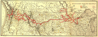
| Description | Map showing the en:Northern Pacific Railway route circa 1900. |
| Date | 29 novembre 2005 (date de téléversement originale) |
| Source |
Transféré de en.wikipedia à Commons par Ian13 utilisant CommonsHelper. Higher resolution JPEG2000 file obtained from [1] and converted to JPEG. |
| Auteur |
Original téléversé par Slambo sur Wikipédia anglais. Later version(s) were uploaded by Ian13 at en.wikipedia. Map created by L.L. Poates Engr'g Co., New York, 1900. Image from the Library of Congress map collection, call number G4126.P3 1900 .L55 RR 502. From Fourth Annual Report of the Northern Pacific Railway company, for the Fiscal Year ending June 30, 1900. Signed in ms: "W. Lowery." Reference: LC Railroad maps, 502. Scale not given. |
| Autorisation (Réutilisation de ce fichier) |
"The Library of Congress ... is not aware of any U.S. copyright protection (see Title 17 of the United States Code) or any other restrictions in the Map Collection materials." (Source retrieved 2005-11-29) |
| Autres versions |
Œuvres dérivées de ce fichier :
|
Conditions d’utilisation
Ce document est dans le domaine public aux États-Unis. Ceci s'applique aux travaux des États-Unis où le copyright a expiré, souvent parce que sa première publication s'est produite avant le 1er janvier 1929. Voir cette page pour davantage d'explication.
|
 | |
 |
Cette image peut ne pas être dans le domaine public en dehors des États-Unis (ceci s'applique particulièrement au Canada, en Chine (pas Hong Kong, Macao, ni Taïwan), en Allemagne ou en Suisse). Le créateur et l'année de la publication sont l'information essentielle et doivent être fournis.
|
Journal des téléversements d’origine
La page de description originale était ici. Tous les noms d'utilisateur qui suivent se rapportent à en.wikipedia.
- 2008-07-15 21:38 Ian13 8850×3358×8 (9327163 bytes) '
- 2005-11-29 12:21 Slambo 552×208×8 (46806 bytes) Map showing the [[Northern Pacific Railroad]] route circa 1900. Map created by L.L. Poates Engr'g Co., New York, 1900. Image from the Library of Congress map collection, call number G4126.P3 1900 .L55 RR 502. [http://memory.loc.gov/cgi-bin/ammemrr.pl?ti
Original edit log
- (cur) (last) 22:43, 15 July 2008 Ian13 (Talk | contribs | block) (1,127 bytes) (tidy + commons tag) (rollback | undo)
- (cur) (last) 22:38, 15 July 2008 Ian13 (Talk | contribs | block) (uploaded a new version of "Image:Northern Pacific Railroad map circa 1900.jpg") (undo)
- (cur) (last) 22:31, 15 July 2008 Ian13 (Talk | contribs | block) m (1,115 bytes) (→Summary: update) (undo)
- (cur) (last) 08:38, 21 June 2006 Lordkinbote (Talk | contribs | block) m (add cat) (undo)
- (cur) (last) 13:21, 29 November 2005 Slambo (Talk | contribs | block) (Map showing the Northern Pacific Railroad route circa 1900. Map created by L.L. Poates Engr'g Co., New York, 1900. Image from the Library of Congress map collection, call number G4126.P3 1900 .L55 RR 502. [http://memory.loc.gov/cgi-bin/ammemrr.pl?ti)
Historique du fichier
Cliquer sur une date et heure pour voir le fichier tel qu'il était à ce moment-là.
| Date et heure | Vignette | Dimensions | Utilisateur | Commentaire | |
|---|---|---|---|---|---|
| actuel | 16 juillet 2008 à 00:03 | 8 850 × 3 358 (8,9 Mio) | Ian13 | {{Information |Description={{en|Map showing the en:Northern Pacific Railroad route circa 1900. Map created by L.L. Poates Engr'g Co., New York, 1900. Image from the Library of Congress map collection, call number G4126.P3 1900 .L55 RR 502. From Four |
Utilisation du fichier
La page suivante utilise ce fichier :
Usage global du fichier
Les autres wikis suivants utilisent ce fichier :
- Utilisation sur de.wikipedia.org
- Utilisation sur en.wikipedia.org
- Utilisation sur it.wikipedia.org
- Utilisation sur ja.wikipedia.org
- Utilisation sur ko.wikipedia.org
- Utilisation sur no.wikipedia.org
- Utilisation sur www.wikidata.org