Aller au contenu

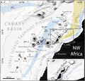
Fichier:Morphometry of Concepcion Bank. Evidence of Geological and Biological Processes on a Large Volcanic Seamount of the Canary Islands Seamount Province. 2016 Rivera et al. Fig. 1.PNG

Le contenu de la page n’est pas pris en charge dans d’autres langues.
Une page de Wikipédia, l'encyclopédie libre.

Fichier d’origine(2 207 × 2 109 pixels, taille du fichier : 1,37 Mio, type MIME : image/png)

Ce fichier et sa description proviennent de Wikimedia Commons.

Description

Description
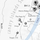
English: Fig 1. General bathymetric map of the Canary Islands Seamount Province (CISP).

Note the seamounts, islands and other relevant physiographic features as well as the regional surface current system. The Canary Basin, the Canary Ridge, the Canary Channel and its diapir belt extending northwards are indicated. Numbers attached to seamounts and islands represent individual oldest age estimate where available, after Van den Bogaard [28]. AC: Azores Current. CC: Canary Current. CUC: Canary Upwelling Current. NEC: North EquatorialCurrent. SV: Selvagens. L: Lanzarote. F: Fuerteventura. GC: Gran Canaria. TF: Tenerife. LP: La Palma. EH: El Hierro. Bathymetry in meters from GEBCO.

DOI: 10.1371/journal.pone.0156337
Date
Source Rivera, J. et al. (2016). "Morphometry of Concepcion Bank: Evidence of Geological and Biological Processes on a Large Volcanic Seamount of the Canary Islands Seamount Province". PLoS ONE 11 (5). DOI:10.1371/journal.pone.0156337. (Fig. 1: [1])
Auteur © 2016 Rivera et al
Autorisation
(Réutilisation de ce fichier)
w:fr:Creative Commons
paternité
Ce fichier est disponible selon les termes de la licence Creative Commons Attribution 4.0 International.
Vous êtes libre :
  • de partager – de copier, distribuer et transmettre cette œuvre
  • d’adapter – de modifier cette œuvre
Sous les conditions suivantes :
  • paternité – Vous devez donner les informations appropriées concernant l'auteur, fournir un lien vers la licence et indiquer si des modifications ont été faites. Vous pouvez faire cela par tout moyen raisonnable, mais en aucune façon suggérant que l’auteur vous soutient ou approuve l’utilisation que vous en faites.
Cette image, qui provient de Rivera, J. et al. (2016). "Morphometry of Concepcion Bank: Evidence of Geological and Biological Processes on a Large Volcanic Seamount of the Canary Islands Seamount Province". PLoS ONE 11 (5). DOI:10.1371/journal.pone.0156337. (Fig. 1: [2]), a été vérifiée le 14 avril 2018 par le relecteur Leoboudv, qui a confirmé qu'à cette date, elle était disponible sous les termes de cette licence.
Autres versions

Légendes

Ajoutez en une ligne la description de ce que représente ce fichier

Éléments décrits dans ce fichier

dépeint

Historique du fichier

Cliquer sur une date et heure pour voir le fichier tel qu'il était à ce moment-là.

Date et heureVignetteDimensionsUtilisateurCommentaire
actuel14 avril 2018 à 07:37Vignette pour la version du 14 avril 2018 à 07:372 207 × 2 109 (1,37 Mio)Asqueladd== {{int:filedesc}} == {{Information |description={{en|1='''Fig 1. General bathymetric map of the Canary Islands Seamount Province (CISP).'''<br /><br />Note the seamounts, islands and other relevant physiographic features as well as the regional surface current system. The Canary Basin, the Canary Ridge, the Canary Channel and its diapir belt extending northwards are indicated. Numbers attached to seamounts and islands represent individual oldest age estimate where available, after Van den B...

La page suivante utilise ce fichier :

Usage global du fichier

Les autres wikis suivants utilisent ce fichier :

Métadonnées