
Fichier:Milpitas view2.JPG

Fichier d’origine (2 104 × 1 580 pixels, taille du fichier : 872 kio, type MIME : image/jpeg)
Ce fichier et sa description proviennent de Wikimedia Commons.
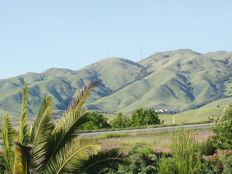
Looking east toward Monument Peak in Milpitas, California. The rightmost (tallest) antenna is Monument Peak, while the leftmost one (second highest, with three "forks" visible) is Mount Allison. The small antenna in the center was recently built. The gully to the far right of the mountainside is Calera Creek. Just to its left is Scott Creek. Most of the area can be accessed via hking trails in Ed R. Levin County Park.
Going right - south. Going left is north. Mount Allison is about a mile north of Monument Peak.
The actual point of Monument Peak is the point lying directly right (south) of the tallest antenna (FCC structure 1019291).
Notice Mount Allison's antenna - it has three "forks" on the top.
Can you see a few hiking trails leading up to Monument Peak?
The houses at the bottom of the mountains are the upper-class Calaveras Ridge Estates on Calaveras Ridge Road.
The hills are golden because of the dry summer season which dehydrates the grass on the hillsides. The hills are considered a high-risk fire hazard region.
| Cette œuvre a été placée dans le domaine public par son auteur, Milpitas guy sur Wikipédia anglais. Ceci s’applique dans le monde entier. Dans certains pays, ceci peut ne pas être possible ; dans ce cas : Milpitas guy accorde à toute personne le droit d’utiliser cette œuvre dans n’importe quel but, sans aucune condition, sauf celles requises par la loi. |
.JPG)
Historique du fichier
Cliquer sur une date et heure pour voir le fichier tel qu'il était à ce moment-là.
| Date et heure | Vignette | Dimensions | Utilisateur | Commentaire | |
|---|---|---|---|---|---|
| actuel | 22 décembre 2006 à 17:33 | | 2 104 × 1 580 (872 kio) | Nk | Looking east toward Monument Peak in Milpitas, California. The rightmost (tallest) antenna is Monument Peak, while the leftmost one (second highest, with three "forks" visible) is Mount Allison. The small antenna in the center was recently built. The gull |
Utilisation du fichier
La page suivante utilise ce fichier :
Usage global du fichier
Les autres wikis suivants utilisent ce fichier :
- Utilisation sur arz.wikipedia.org
- Utilisation sur ceb.wikipedia.org
- Utilisation sur de.wikipedia.org
- Utilisation sur en.wikipedia.org
- Utilisation sur eo.wikipedia.org
- Utilisation sur es.wikipedia.org
- Utilisation sur he.wikipedia.org
- Utilisation sur ja.wikipedia.org
- Utilisation sur lld.wikipedia.org
- Utilisation sur pam.wikipedia.org
- Utilisation sur uz.wikipedia.org
- Utilisation sur www.wikidata.org