
Fichier:MedU.png

Taille de cet aperçu : 800 × 581 pixels. Autres résolutions : 320 × 232 pixels | 640 × 465 pixels | 1 024 × 744 pixels | 1 280 × 930 pixels | 2 100 × 1 525 pixels.
Fichier d’origine (2 100 × 1 525 pixels, taille du fichier : 129 kio, type MIME : image/png)
Ce fichier et sa description proviennent de Wikimedia Commons.

|
Une version vectorielle de cette image existe, dans le format « SVG ». Si elle n’est pas inférieure, elle devrait être utilisée à la place de la présente version pour des affichages en plus grandes dimensions ou nécessitant une meilleure résolution.
File:MedU.png → File:EU27-2008-Union for the Mediterranean.svg
Pour plus d’informations sur les images vectorielles, consultez la page de transition de Commons vers le format SVG. Voir aussi les informations à propos de la manière dont le logiciel MediaWiki gère les images au format SVG. |
 |
Description
Català: Unió Mediterrània. Possibles candidats a la Unió Mediterrània (blau) amb la resta de la Unió Europea (gris fosc).
Deutsch: Diagramm der von Nicolas Sarkozy vorgeschlagenen Mittelmeerunion. Meine Arbeit, angepasst von einem allgemeinen Bild auf wikicommons: Image:BlankMap-Europe-v4.png
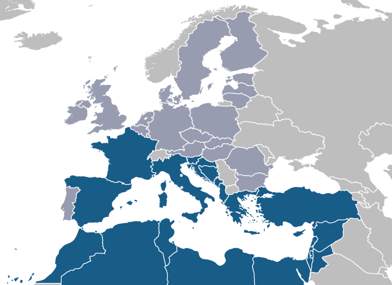
English: Map of Sarkozy's proposed Mediterranean Union. Own work, adapted from a public image on wikicommons: Image:BlankMap-Europe-v4.png. Possible membership of the Mediterranean Union (blue) with the rest of the European Union (dark grey).
Ελληνικά: Μεσογειακή ένωση
Español: Mapa de la Unión Mediterránea propuesta por Sarkozy, adaptado de una imagen pública en wikicommons: Image:BlankMap-Europe-v4.png.
Français : Carte de l'union méditerranéenne proposée de Sarkozy's. Mon travail, adapté d'une image publique sur wikicommons: Image:BlankMap-Europe-v4.png. Membres éventuels de l’Union méditerranéenne (en bleu), avec le reste de l’Union européenne (gris foncé).
עברית: איחוד מדינות הים התיכון
Italiano: Programma dell'unione mediterranea proposta da Sarkozy. Il mio lavoro, adattato da un'immagine pubblica sui wikicommons: Image:BlankMap-Europe-v4.png. Possibili stati membri dell'Unione Mediterranea (blu) con il resto dell'Unione Europea (grigio scuro).
Nederlands: Kaart van Sarkozy's Mediterrane Unie die van een openbaar beeld op wikicommons wordt aangepast: Image:BlankMap-Europe-v4.png. Mogelijk lidmaatschap van de Mediterrane Unie (blauw) met de rest van de Europese Unie (donkergrijs)
Português: Mapa da União Mediterrânica proposta de Sarkozy's. Meu trabalho, adaptado de uma imagem pública em wikicommons: Image:BlankMap-Europe-v4.png. Membros previsíveis da União Mediterrânica (azul). A cinzento escuro os restantes membros da União Europeia.
Türkçe: Akdeniz Birliği
Русский: Предполагаемые участники Средиземноморсого союза;
Средиземноморские страны(синий) Страны-члены ЕС(светло-серый)
Conditions d’utilisation
| Moi, propriétaire des droits d’auteur sur cette œuvre, la place dans le domaine public. Ceci s'applique dans le monde entier. Dans certains pays, ceci peut ne pas être possible ; dans ce cas : J’accorde à toute personne le droit d’utiliser cette œuvre dans n’importe quel but, sans aucune condition, sauf celles requises par la loi. |
Historique du fichier
Cliquer sur une date et heure pour voir le fichier tel qu'il était à ce moment-là.
| Date et heure | Vignette | Dimensions | Utilisateur | Commentaire | |
|---|---|---|---|---|---|
| actuel | 23 mai 2008 à 18:10 | | 2 100 × 1 525 (129 kio) | Nightstallion | latest proposal foresees all neighbour countries as part |
| 16 mars 2008 à 11:18 |  | 2 100 × 1 525 (120 kio) | J. Patrick Fischer | Slovenija has a coast to Med. | |
| 14 mars 2008 à 13:10 |  | 2 100 × 1 525 (44 kio) | J. Patrick Fischer | Portugal is not bordering the Mediteranian Sea | |
| 19 janvier 2008 à 00:48 |  | 2 100 × 1 525 (60 kio) | JLogan | changed ministates from EU dark grey to light grey and added Pal. | |
| 24 août 2007 à 11:35 |  | 2 100 × 1 525 (43 kio) | Roke~commonswiki | ||
| 24 août 2007 à 11:22 |  | 2 100 × 1 525 (132 kio) | Roke~commonswiki | fix low countries | |
| 17 août 2007 à 12:04 |  | 2 100 × 1 525 (75 kio) | Roke~commonswiki | better base map, same colours | |
| 16 avril 2007 à 23:34 |  | 534 × 534 (15 kio) | JLogan | Map of Sarkozy's proposed Mediterranean Union. Own work, adapted from from public image on wikicommons: Image:Euro-med.png |
Utilisation du fichier
Aucune page n’utilise ce fichier.
Usage global du fichier
Les autres wikis suivants utilisent ce fichier :
- Utilisation sur be.wikipedia.org
- Utilisation sur ca.wikipedia.org
- Utilisation sur de.wikipedia.org
- Utilisation sur zh.wikipedia.org